Property Record
7 Carl Thompson Rd, Westford, MA 01886


NEARBY LISTINGS FOR SALE OR LEASE
-
-
View all Westford listings for lease on LoopNet.com
Property Detail
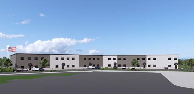
7 Carl Thompson Rd
Commercialofficeresidentialmixeduse
Middlesex
X
Massachusetts
25017C0231F
4.27 AC
2025
Groton/Townsend
2025
Boston
318100
Boston-Cambridge-Newton, MA-NH
3,488 SF
WFOR-000077-000029
DEMOGRAPHICS near 7 Carl Thompson Rd
1 Mile
3 Mile
5 Mile
2024 Total Population
4,104
33,758
103,638
2029 Population
4,118
33,654
102,493
Pop Growth 2024-2029
+ 0.34%
(0.31%)
(1.10%)
Average Age
42
42
41
2024 Total Households
1,437
12,391
37,433
HH Growth 2024-2029
+ 0.21%
(0.52%)
(1.20%)
Median Household Inc
$145,092
$134,242
$112,613
Avg Household Size
2.80
2.70
2.70
2024 Avg HH Vehicles
2.00
2.00
2.00
Median Home Value
$643,329
$588,111
$505,831
Median Year Built
1968
1980
1973
Nearby Places
Map Layers
Map Styles
 Street
 Aerial
- Restaurants
- Banks
- Shops
- Fitness
- Groceries
PUBLIC TRANSPORTATION
COMMUTER RAIL
Lowell (Lowell Line - Massachusetts Bay Transportation Authority Commuter Rail (Purple Line))
DRIVE
WALK
Distance
Lowell (Lowell Line - Massachusetts Bay Transportation Authority Commuter Rail (Purple Line))
12 min
7.4 mi
North Billerica (Lowell Line - Massachusetts Bay Transportation Authority Commuter Rail (Purple Line))
DRIVE
WALK
Distance
North Billerica (Lowell Line - Massachusetts Bay Transportation Authority Commuter Rail (Purple Line))
16 min
9.7 mi
AIRPORT
Manchester Boston Regional
DRIVE
WALK
Distance
Manchester Boston Regional
38 min
26.3 mi
General Edward Lawrence Logan International
DRIVE
WALK
Distance
General Edward Lawrence Logan International
49 min
33.2 mi
Worcester Regional
DRIVE
WALK
Distance
Worcester Regional
60 min
42.4 mi
Freight Ports
Port of Boston
DRIVE
WALK
Distance
Port of Boston
50 min
32.9 mi
SALE & LEASE HISTORY
LISTING DATE
SALE/LEASE

Dec 03, 2024
For Lease
Nearby Properties
Address
Land Use
TOTAL SIZE
Lot Size
Zoning
Address
Land Use
TOTAL SIZE
Lot Size
Zoning
23,251 SF
18.20 AC
SMF
Address
Land Use
TOTAL SIZE
Lot Size
Zoning
269,952 SF
18.11 AC
P
Address
Land Use
TOTAL SIZE
Lot Size
Zoning
68.15 AC
R1
Address
Land Use
TOTAL SIZE
Lot Size
Zoning
38.26 AC
P
Address
Land Use
TOTAL SIZE
Lot Size
Zoning
119,130 SF
22.36 AC
RA
Address
Land Use
TOTAL SIZE
Lot Size
Zoning
85,450 SF
32.07 AC
RA
Address
Land Use
TOTAL SIZE
Lot Size
Zoning
4.67 AC
IA
Address
Land Use
TOTAL SIZE
Lot Size
Zoning
135,324 SF
70.07 AC
R1
Address
Land Use
TOTAL SIZE
Lot Size
Zoning
90,463 SF
8.56 AC
RA
Address
Land Use
TOTAL SIZE
Lot Size
Zoning
177.27 AC
R1
Address
Land Use
TOTAL SIZE
Lot Size
Zoning
12.26 AC
P
Address
Land Use
TOTAL SIZE
Lot Size
Zoning
82,182 SF
13.86 AC
P
Address
Land Use
TOTAL SIZE
Lot Size
Zoning
58,766 SF
21.98 AC
RA
Address
Land Use
TOTAL SIZE
Lot Size
Zoning
50,000 SF
33.40 AC
IA
Address
Land Use
TOTAL SIZE
Lot Size
Zoning
27.80 AC
P
Address
Land Use
TOTAL SIZE
Lot Size
Zoning
Address
Land Use
TOTAL SIZE
Lot Size
Zoning
41,635 SF
5.33 AC
RA
Address
Land Use
TOTAL SIZE
Lot Size
Zoning
17.86 AC
I1
Address
Land Use
TOTAL SIZE
Lot Size
Zoning
28,478 SF
16.60 AC
RB
Address
Land Use
TOTAL SIZE
Lot Size
Zoning
83,000 SF
2.78 AC
R1
Address
Land Use
TOTAL SIZE
Lot Size
Zoning
4.62 AC
RC
Address
Land Use
TOTAL SIZE
Lot Size
Zoning
1.91 AC
RC
Address
Land Use
TOTAL SIZE
Lot Size
Zoning
69,619 SF
2.85 AC
CB
Address
Land Use
TOTAL SIZE
Lot Size
Zoning
2.59 AC
I1
Address
Land Use
TOTAL SIZE
Lot Size
Zoning
23,668 SF
30 AC
RA
Address
Land Use
TOTAL SIZE
Lot Size
Zoning
26,426 SF
1.59 AC
RA
Address
Land Use
TOTAL SIZE
Lot Size
Zoning
177.88 AC
R1
Address
Land Use
TOTAL SIZE
Lot Size
Zoning
900 SF
4.41 AC
I1
Address
Land Use
TOTAL SIZE
Lot Size
Zoning
121,916 SF
7.78 AC
CD
Address
Land Use
TOTAL SIZE
Lot Size
Zoning
10.20 AC
RB
The World's #1 Commercial Real Estate Marketplace
Connect with us
© 2025 CoStar Group
The information above has been obtained from sources believed reliable. While we do not doubt its accuracy we have not verified it and make no guarantee, warranty or representation about it. It is your responsibility to independently confirm its accuracy and completeness. Any projections, opinions, assumptions, or estimates used are for example only and do not represent the current or future performance of the property. The value of this transaction to you depends on tax and other factors which should be evaluated by your tax, financial, and legal advisors. You and your advisors should conduct a careful, independent investigation of the property to determine to your satisfaction the suitability of the property for your needs.