Property Record
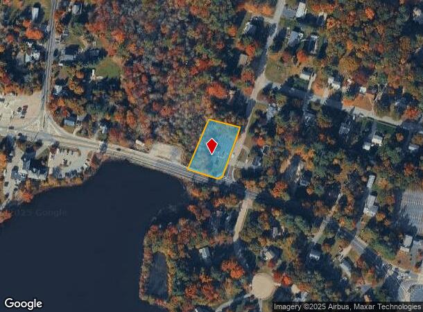
7 Gorwin Dr, Hanson, MA 02341
Property Detail
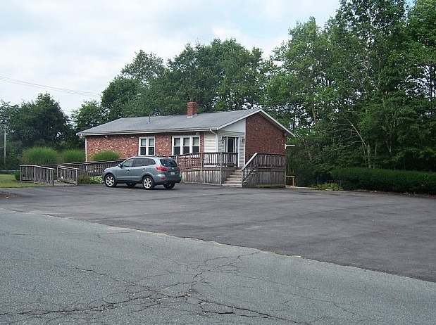
7 Gorwin Dr
Medicalbuilding
Plymouth
X
Massachusetts
25023C0203K
0.76 AC
2025
Route 3 South
2025
Boston
522101
Boston-Cambridge-Newton, MA-NH
2,484 SF
HANS-000081-000000-000241
NEARBY LISTINGS FOR SALE OR LEASE
-
-
View all Hanson listings for sale on LoopNet.com
DEMOGRAPHICS near 7 Gorwin Dr
1 mile
3 mile
5 mile
2024 Total Population
2,432
21,657
70,992
2029 Population
2,408
21,638
70,908
Pop Growth 2024-2029
(0.99%)
(0.09%)
(0.12%)
Average Age
43
42
42
2024 Total Households
900
7,683
25,901
HH Growth 2024-2029
(1.22%)
(0.18%)
(0.21%)
Median Household Inc
$116,805
$130,021
$118,767
Avg Household Size
2.70
2.80
2.70
2024 Avg HH Vehicles
2.00
2.00
2.00
Median Home Value
$451,562
$481,783
$477,431
Median Year Built
1968
1971
1970
Nearby Places
Map Layers
Map Styles
 Street
 Aerial
Transit
 Traffic
 Biking
Places
Listings with unknown addresses are not visible on the map
- Restaurants
- Banks
- Shops
- Fitness
- Groceries
PUBLIC TRANSPORTATION
COMMUTER RAIL
Hanson (Kingston/Plymouth Line - Massachusetts Bay Transportation Authority Commuter Rail (Purple Line))
Drive
Walk
Distance
Hanson (Kingston/Plymouth Line - Massachusetts Bay Transportation Authority Commuter Rail (Purple Line))
6 min
2.4 mi
Whitman (Kingston/Plymouth Line - Massachusetts Bay Transportation Authority Commuter Rail (Purple Line))
Drive
Walk
Distance
Whitman (Kingston/Plymouth Line - Massachusetts Bay Transportation Authority Commuter Rail (Purple Line))
8 min
4.1 mi
AIRPORT
General Edward Lawrence Logan International
Drive
Walk
Distance
General Edward Lawrence Logan International
47 min
29.2 mi
Freight Ports
Port of Boston
Drive
Walk
Distance
Port of Boston
45 min
27.0 mi
Nearby Properties
Address
Land Use
TOTAL SIZE
Lot Size
Zoning
Address
Land Use
TOTAL SIZE
Lot Size
Zoning
69.93 AC
100
Address
Land Use
TOTAL SIZE
Lot Size
Zoning
99,138 SF
83.32 AC
100
Address
Land Use
TOTAL SIZE
Lot Size
Zoning
103,880 SF
30.51 AC
Address
Land Use
TOTAL SIZE
Lot Size
Zoning
25,262 SF
244 AC
Address
Land Use
TOTAL SIZE
Lot Size
Zoning
8.32 AC
Address
Land Use
TOTAL SIZE
Lot Size
Zoning
57,730 SF
34.19 AC
Address
Land Use
TOTAL SIZE
Lot Size
Zoning
64,168 SF
10 AC
100
Address
Land Use
TOTAL SIZE
Lot Size
Zoning
16.12 AC
100
Address
Land Use
TOTAL SIZE
Lot Size
Zoning
23.60 AC
I
Address
Land Use
TOTAL SIZE
Lot Size
Zoning
37,542 SF
9.90 AC
I
Address
Land Use
TOTAL SIZE
Lot Size
Zoning
78,601 SF
6.83 AC
100
Address
Land Use
TOTAL SIZE
Lot Size
Zoning
36,129 SF
36.70 AC
Address
Land Use
TOTAL SIZE
Lot Size
Zoning
51,280 SF
3.90 AC
100
Address
Land Use
TOTAL SIZE
Lot Size
Zoning
8.20 AC
100
Address
Land Use
TOTAL SIZE
Lot Size
Zoning
38,790 SF
7.82 AC
Address
Land Use
TOTAL SIZE
Lot Size
Zoning
42,152 SF
8.30 AC
Address
Land Use
TOTAL SIZE
Lot Size
Zoning
57.50 AC
100
Address
Land Use
TOTAL SIZE
Lot Size
Zoning
1,640 SF
854.31 AC
100
Address
Land Use
TOTAL SIZE
Lot Size
Zoning
14,464 SF
3.94 AC
100
Address
Land Use
TOTAL SIZE
Lot Size
Zoning
44,020 SF
7.38 AC
Address
Land Use
TOTAL SIZE
Lot Size
Zoning
67.01 AC
I
Address
Land Use
TOTAL SIZE
Lot Size
Zoning
26,008 SF
5.26 AC
RESIDE
Address
Land Use
TOTAL SIZE
Lot Size
Zoning
51,968 SF
11.27 AC
I
Address
Land Use
TOTAL SIZE
Lot Size
Zoning
54,705 SF
14.77 AC
100
Address
Land Use
TOTAL SIZE
Lot Size
Zoning
56,750 SF
2.85 AC
COMMER
Address
Land Use
TOTAL SIZE
Lot Size
Zoning
32,568 SF
1.89 AC
FLEX O
Address
Land Use
TOTAL SIZE
Lot Size
Zoning
9,000 SF
105.77 AC
Address
Land Use
TOTAL SIZE
Lot Size
Zoning
64,000 SF
3.25 AC
Address
Land Use
TOTAL SIZE
Lot Size
Zoning
34,136 SF
3.45 AC
100
Address
Land Use
TOTAL SIZE
Lot Size
Zoning
9,240 SF
72 AC
The World's #1 Commercial Real Estate Marketplace
Connect with us
© 2026 CoStar Group
The information above has been obtained from sources believed reliable. While we do not doubt its accuracy we have not verified it and make no guarantee, warranty or representation about it. It is your responsibility to independently confirm its accuracy and completeness. Any projections, opinions, assumptions, or estimates used are for example only and do not represent the current or future performance of the property. The value of this transaction to you depends on tax and other factors which should be evaluated by your tax, financial, and legal advisors. You and your advisors should conduct a careful, independent investigation of the property to determine to your satisfaction the suitability of the property for your needs.