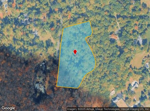
Property Record
7 Hardscrabble Rd, Bernards, NJ 07920
NEARBY LISTINGS FOR SALE OR LEASE
Property Detail
7 Hardscrabble Rd
Newark, NJ-PA
Buckley
02-00103-0000-00004
ADDITIONAL LOTS: CONS/GREEN ESMT
Vacantlandnec
Somerset
AE
New Jersey
34035C0056E
4
2024
6.58 AC
2025
Route 78 East
054100
Northern New Jersey
DEMOGRAPHICS near 7 Hardscrabble Rd
1 Mile
3 Mile
5 Mile
2024 Total Population
5,003
29,626
54,815
2029 Population
5,000
29,530
54,650
Pop Growth 2024-2029
(0.06%)
(0.32%)
(0.30%)
Average Age
43
43
43
2024 Total Households
1,740
10,930
19,811
HH Growth 2024-2029
(0.11%)
(0.34%)
(0.35%)
Median Household Inc
$196,249
$170,423
$176,471
Avg Household Size
2.80
2.60
2.70
2024 Avg HH Vehicles
2.00
2.00
2.00
Median Home Value
$798,107
$699,166
$742,473
Median Year Built
1969
1979
1981
Nearby Places
Map Layers
Map Styles
 Street
 Aerial
- Restaurants
- Banks
- Shops
- Fitness
- Groceries
PUBLIC TRANSPORTATION
COMMUTER RAIL
Bernardsville (Morris & Essex Gladstone Branch - NJ Transit Commuter Rail (NJ Transit))
DRIVE
WALK
Distance
Bernardsville (Morris & Essex Gladstone Branch - NJ Transit Commuter Rail (NJ Transit))
5 min
2.8 mi
Basking Ridge (Morris & Essex Gladstone Branch - NJ Transit Commuter Rail (NJ Transit))
DRIVE
WALK
Distance
Basking Ridge (Morris & Essex Gladstone Branch - NJ Transit Commuter Rail (NJ Transit))
5 min
2.9 mi
AIRPORT
Newark Liberty International
DRIVE
WALK
Distance
Newark Liberty International
37 min
28.8 mi
Freight Ports
New York Container Terminal
DRIVE
WALK
Distance
New York Container Terminal
47 min
31.7 mi
Nearby Properties
Address
Land Use
TOTAL SIZE
Lot Size
Zoning
Address
Land Use
TOTAL SIZE
Lot Size
Zoning
133.08 AC
E1
Address
Land Use
TOTAL SIZE
Lot Size
Zoning
839.97 AC
P1
Address
Land Use
TOTAL SIZE
Lot Size
Zoning
34.78 AC
P3
Address
Land Use
TOTAL SIZE
Lot Size
Zoning
512.60 AC
PL
Address
Land Use
TOTAL SIZE
Lot Size
Zoning
79 AC
5-AC
Address
Land Use
TOTAL SIZE
Lot Size
Zoning
7,872 SF
15.70 AC
Address
Land Use
TOTAL SIZE
Lot Size
Zoning
96,631 SF
13.69 AC
OB
Address
Land Use
TOTAL SIZE
Lot Size
Zoning
330.60 AC
PL
Address
Land Use
TOTAL SIZE
Lot Size
Zoning
8.67 AC
DCOR
Address
Land Use
TOTAL SIZE
Lot Size
Zoning
211,662 SF
33.83 AC
E5
Address
Land Use
TOTAL SIZE
Lot Size
Zoning
39.47 AC
PL
Address
Land Use
TOTAL SIZE
Lot Size
Zoning
100,860 SF
14.06 AC
OB
Address
Land Use
TOTAL SIZE
Lot Size
Zoning
277.10 AC
R-10
Address
Land Use
TOTAL SIZE
Lot Size
Zoning
2,381 SF
34.92 AC
E1
Address
Land Use
TOTAL SIZE
Lot Size
Zoning
2,976 SF
19.80 AC
SH2
Address
Land Use
TOTAL SIZE
Lot Size
Zoning
272.91 AC
PL
Address
Land Use
TOTAL SIZE
Lot Size
Zoning
16,496 SF
157.52 AC
R110
Address
Land Use
TOTAL SIZE
Lot Size
Zoning
26.04 AC
DCOR
Address
Land Use
TOTAL SIZE
Lot Size
Zoning
141.24 AC
Address
Land Use
TOTAL SIZE
Lot Size
Zoning
97.51 AC
PL
Address
Land Use
TOTAL SIZE
Lot Size
Zoning
65.51 AC
R4
Address
Land Use
TOTAL SIZE
Lot Size
Zoning
29,905 SF
7.47 AC
RR
Address
Land Use
TOTAL SIZE
Lot Size
Zoning
87.32 AC
RR
Address
Land Use
TOTAL SIZE
Lot Size
Zoning
34,806 SF
6.28 AC
SH1
Address
Land Use
TOTAL SIZE
Lot Size
Zoning
2,141 SF
111 AC
R1
Address
Land Use
TOTAL SIZE
Lot Size
Zoning
1,440 SF
125.03 AC
R-5
Address
Land Use
TOTAL SIZE
Lot Size
Zoning
18.30 AC
R6
Address
Land Use
TOTAL SIZE
Lot Size
Zoning
9,540 SF
9.39 AC
E5
Address
Land Use
TOTAL SIZE
Lot Size
Zoning
15,207 SF
5.50 AC
R110
Address
Land Use
TOTAL SIZE
Lot Size
Zoning
16,867 SF
3.90 AC
R1
The World's #1 Commercial Real Estate Marketplace
Connect with us
© 2025 CoStar Group
The information above has been obtained from sources believed reliable. While we do not doubt its accuracy we have not verified it and make no guarantee, warranty or representation about it. It is your responsibility to independently confirm its accuracy and completeness. Any projections, opinions, assumptions, or estimates used are for example only and do not represent the current or future performance of the property. The value of this transaction to you depends on tax and other factors which should be evaluated by your tax, financial, and legal advisors. You and your advisors should conduct a careful, independent investigation of the property to determine to your satisfaction the suitability of the property for your needs.