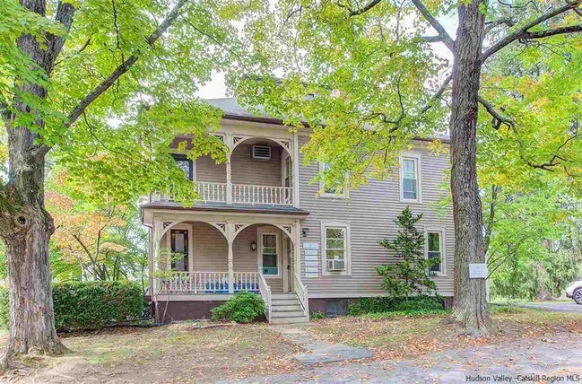
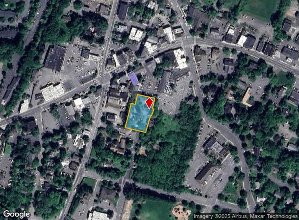
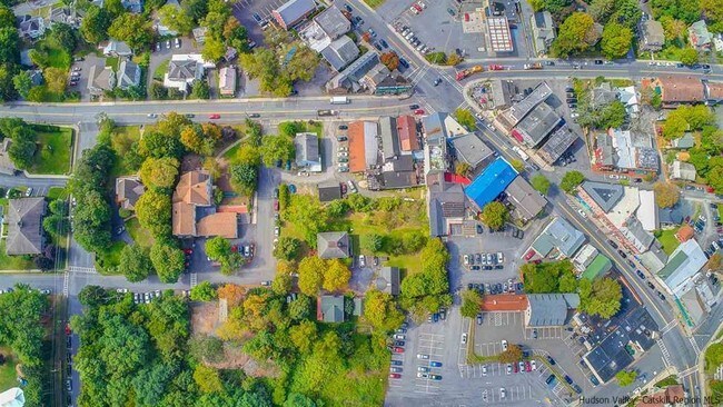
Property Record
7 Innis Ave, New Paltz, NY 12561
NEARBY LISTINGS FOR SALE OR LEASE
-
-
-
Trail Link Collective | 145 North Chestnut Street
New Paltz, NY 12561
$32.50 SF/YR
747 - 2,167 SF
Office
-
View all New Paltz listings for sale on LoopNet.com
Property Detail
7 Innis Ave
3801-086.034-0004-009.000-0000
Ulster
Commercialofficeresidentialmixeduse
New York
X
9.000
36111C0755E
0.60 AC
0
Newburgh/Kingston
2024
Other Market Areas
953500
Kingston, NY
2,446 SF
DEMOGRAPHICS near 7 Innis Ave
1 Mile
3 Mile
5 Mile
2024 Total Population
8,056
14,301
22,110
2029 Population
8,030
14,252
21,989
Pop Growth 2024-2029
(0.32%)
(0.34%)
(0.55%)
Average Age
34
38
41
2024 Total Households
2,418
4,810
7,982
HH Growth 2024-2029
(0.83%)
(0.58%)
(0.74%)
Median Household Inc
$55,208
$84,784
$86,860
Avg Household Size
2.00
2.20
2.30
2024 Avg HH Vehicles
1.00
2.00
2.00
Median Home Value
$375,458
$406,545
$372,147
Median Year Built
1971
1973
1974
Nearby Places
- Restaurants
- Banks
- Shops
- Fitness
- Groceries
PUBLIC TRANSPORTATION
AIRPORT
New York Stewart International
DRIVE
WALK
Distance
New York Stewart International
35 min
23.7 mi
Freight Ports
Albany, NY Port
DRIVE
WALK
Distance
Albany, NY Port
84 min
68.0 mi
SALE & LEASE HISTORY
LISTING DATE
SALE/LEASE

Sep 27, 2019
For Sale
Nearby Properties
Address
Land Use
TOTAL SIZE
Lot Size
Zoning
Address
Land Use
TOTAL SIZE
Lot Size
Zoning
53,355 SF
189.30 AC
16
Address
Land Use
TOTAL SIZE
Lot Size
Zoning
31.40 AC
R1
Address
Land Use
TOTAL SIZE
Lot Size
Zoning
124,321 SF
25.17 AC
LB
Address
Land Use
TOTAL SIZE
Lot Size
Zoning
80,863 SF
17.30 AC
R2
Address
Land Use
TOTAL SIZE
Lot Size
Zoning
94,258 SF
55 AC
I1
Address
Land Use
TOTAL SIZE
Lot Size
Zoning
68,100 SF
14.20 AC
B2
Address
Land Use
TOTAL SIZE
Lot Size
Zoning
55,616 SF
10.90 AC
R3
Address
Land Use
TOTAL SIZE
Lot Size
Zoning
14,400 SF
11.50 AC
R2
Address
Land Use
TOTAL SIZE
Lot Size
Zoning
Address
Land Use
TOTAL SIZE
Lot Size
Zoning
8,932 SF
6.72 AC
R2
Address
Land Use
TOTAL SIZE
Lot Size
Zoning
1,568 SF
74.50 AC
RR1.5
Address
Land Use
TOTAL SIZE
Lot Size
Zoning
64,761 SF
18 AC
R1
Address
Land Use
TOTAL SIZE
Lot Size
Zoning
9,672 SF
8.58 AC
RV
Address
Land Use
TOTAL SIZE
Lot Size
Zoning
10,206 SF
10.60 AC
I1
Address
Land Use
TOTAL SIZE
Lot Size
Zoning
2,276 SF
10.60 AC
I1
Address
Land Use
TOTAL SIZE
Lot Size
Zoning
63,280 SF
1.40 AC
B3
Address
Land Use
TOTAL SIZE
Lot Size
Zoning
32,296 SF
16.30 AC
B2
Address
Land Use
TOTAL SIZE
Lot Size
Zoning
784 SF
18.70 AC
F
Address
Land Use
TOTAL SIZE
Lot Size
Zoning
54,884 SF
2.40 AC
I1
Address
Land Use
TOTAL SIZE
Lot Size
Zoning
586 SF
836.90 AC
10
Address
Land Use
TOTAL SIZE
Lot Size
Zoning
5,882 SF
33.70 AC
LI
Address
Land Use
TOTAL SIZE
Lot Size
Zoning
80,656 SF
34.63 AC
I1
Address
Land Use
TOTAL SIZE
Lot Size
Zoning
9,162 SF
5.40 AC
R3
Address
Land Use
TOTAL SIZE
Lot Size
Zoning
11,168 SF
1.67 AC
R2
Address
Land Use
TOTAL SIZE
Lot Size
Zoning
3,120 SF
115.50 AC
A1 5
Address
Land Use
TOTAL SIZE
Lot Size
Zoning
37,962 SF
8.80 AC
R1
Address
Land Use
TOTAL SIZE
Lot Size
Zoning
48,520 SF
5.40 AC
B2
Address
Land Use
TOTAL SIZE
Lot Size
Zoning
1,715 SF
170.40 AC
A15
Address
Land Use
TOTAL SIZE
Lot Size
Zoning
8,155 SF
4.90 AC
R1
Address
Land Use
TOTAL SIZE
Lot Size
Zoning
37,434 SF
2.60 AC
R2
The World's #1 Commercial Real Estate Marketplace
Connect with us
© 2025 CoStar Group
The information above has been obtained from sources believed reliable. While we do not doubt its accuracy we have not verified it and make no guarantee, warranty or representation about it. It is your responsibility to independently confirm its accuracy and completeness. Any projections, opinions, assumptions, or estimates used are for example only and do not represent the current or future performance of the property. The value of this transaction to you depends on tax and other factors which should be evaluated by your tax, financial, and legal advisors. You and your advisors should conduct a careful, independent investigation of the property to determine to your satisfaction the suitability of the property for your needs.