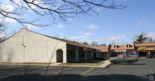
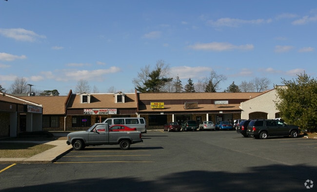
Property Record
7 Juliustown Rd, Browns Mills, NJ 08015


NEARBY LISTINGS FOR SALE OR LEASE
Property Detail
7 Juliustown Rd
29-00539-0000-00015-02
Burlington
Storemultistory
New Jersey
X
15.2
34005C0302F
2.67 AC
2024
South Burlington County
2025
Philadelphia
702207
Philadelphia-Camden-Wilmington, PA-NJ-DE-MD
17,675 SF
DEMOGRAPHICS near 7 Juliustown Rd
1 Mile
3 Mile
5 Mile
2024 Total Population
6,062
17,561
31,604
2029 Population
6,236
18,038
32,295
Pop Growth 2024-2029
+ 2.87%
+ 2.72%
+ 2.19%
Average Age
41
41
39
2024 Total Households
2,314
6,408
10,057
HH Growth 2024-2029
+ 2.90%
+ 2.81%
+ 2.40%
Median Household Inc
$55,291
$72,615
$78,138
Avg Household Size
2.50
2.60
2.70
2024 Avg HH Vehicles
2.00
2.00
2.00
Median Home Value
$170,351
$168,511
$180,584
Median Year Built
1974
1973
1975
Nearby Places
Map Layers
Map Styles
 Street
 Aerial
- Restaurants
- Banks
- Shops
- Fitness
- Groceries
PUBLIC TRANSPORTATION
AIRPORT
Trenton Mercer
DRIVE
WALK
Distance
Trenton Mercer
50 min
31.1 mi
Philadelphia International
DRIVE
WALK
Distance
Philadelphia International
64 min
41.1 mi
Freight Ports
South Jersey Port
DRIVE
WALK
Distance
South Jersey Port
47 min
30.9 mi
SALE & LEASE HISTORY
LISTING DATE
SALE/LEASE

Oct 21, 2024
For Lease
Nearby Properties
Address
Land Use
TOTAL SIZE
Lot Size
Zoning
Address
Land Use
TOTAL SIZE
Lot Size
Zoning
4.95 AC
Address
Land Use
TOTAL SIZE
Lot Size
Zoning
21.97 AC
Address
Land Use
TOTAL SIZE
Lot Size
Zoning
1,812.67 AC
Address
Land Use
TOTAL SIZE
Lot Size
Zoning
38.59 AC
Address
Land Use
TOTAL SIZE
Lot Size
Zoning
31.07 AC
Address
Land Use
TOTAL SIZE
Lot Size
Zoning
22.89 AC
Address
Land Use
TOTAL SIZE
Lot Size
Zoning
16.31 AC
Address
Land Use
TOTAL SIZE
Lot Size
Zoning
9.39 AC
Address
Land Use
TOTAL SIZE
Lot Size
Zoning
11.67 AC
Address
Land Use
TOTAL SIZE
Lot Size
Zoning
9,792 SF
2.67 AC
Address
Land Use
TOTAL SIZE
Lot Size
Zoning
21.20 AC
Address
Land Use
TOTAL SIZE
Lot Size
Zoning
8.97 AC
Address
Land Use
TOTAL SIZE
Lot Size
Zoning
20.52 AC
Address
Land Use
TOTAL SIZE
Lot Size
Zoning
46.04 AC
Address
Land Use
TOTAL SIZE
Lot Size
Zoning
1,886.59 AC
Address
Land Use
TOTAL SIZE
Lot Size
Zoning
4.68 AC
Address
Land Use
TOTAL SIZE
Lot Size
Zoning
Address
Land Use
TOTAL SIZE
Lot Size
Zoning
3,660 SF
4.58 AC
Address
Land Use
TOTAL SIZE
Lot Size
Zoning
40.57 AC
Address
Land Use
TOTAL SIZE
Lot Size
Zoning
709.56 AC
Address
Land Use
TOTAL SIZE
Lot Size
Zoning
2.49 AC
Address
Land Use
TOTAL SIZE
Lot Size
Zoning
0.60 AC
Address
Land Use
TOTAL SIZE
Lot Size
Zoning
12,572 SF
4.23 AC
Address
Land Use
TOTAL SIZE
Lot Size
Zoning
Address
Land Use
TOTAL SIZE
Lot Size
Zoning
10,880 SF
1.48 AC
Address
Land Use
TOTAL SIZE
Lot Size
Zoning
20.30 AC
Address
Land Use
TOTAL SIZE
Lot Size
Zoning
19,375 SF
3.68 AC
Address
Land Use
TOTAL SIZE
Lot Size
Zoning
527 AC
Address
Land Use
TOTAL SIZE
Lot Size
Zoning
450.87 AC
Address
Land Use
TOTAL SIZE
Lot Size
Zoning
1,658 SF
5.43 AC
The World's #1 Commercial Real Estate Marketplace
Connect with us
© 2025 CoStar Group
The information above has been obtained from sources believed reliable. While we do not doubt its accuracy we have not verified it and make no guarantee, warranty or representation about it. It is your responsibility to independently confirm its accuracy and completeness. Any projections, opinions, assumptions, or estimates used are for example only and do not represent the current or future performance of the property. The value of this transaction to you depends on tax and other factors which should be evaluated by your tax, financial, and legal advisors. You and your advisors should conduct a careful, independent investigation of the property to determine to your satisfaction the suitability of the property for your needs.