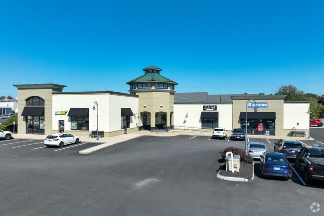
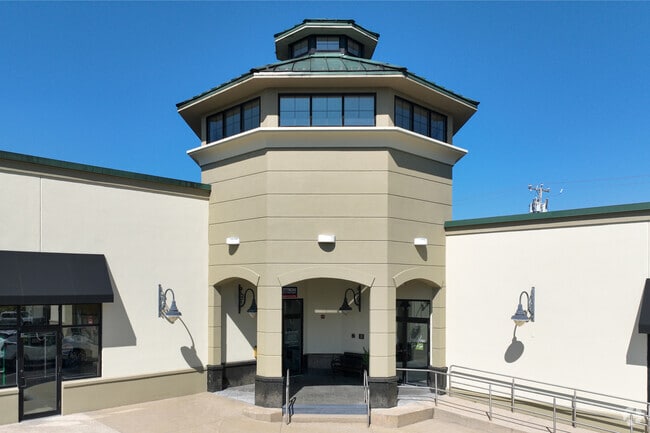
Property Record
7 Lafayette Rd, North Hampton, NH 03862

Property Detail
7 Lafayette Rd
Commercialnec
ROCKINGHAM
IB/R
New Hampshire
B and X Area of moderate flood hazard, usually the area between the limits of the 100-year and 500-year floods.
2.09 AC
2025
Rockingham
2025
Boston
066000
Boston-Cambridge-Newton, MA-NH
11,080 SF
NHTN-000003-000080
NEARBY LISTINGS FOR SALE OR LEASE
DEMOGRAPHICS near 7 Lafayette Rd
1 mile
3 mile
5 mile
2025 Total Population
3,079
19,561
40,383
2030 Population
3,088
20,016
41,601
Pop Growth 2025-2030
+ 0.29%
+ 2.33%
+ 3.02%
Average Age
46
49
48
2025 Total Households
1,215
8,621
17,833
HH Growth 2025-2030
+ 0.08%
+ 2.34%
+ 3.21%
Median Household Inc
$129,268
$100,949
$102,089
Avg Household Size
2.40
2.20
2.20
2025 Avg HH Vehicles
2.00
2.00
2.00
Median Home Value
$672,138
$647,344
$675,967
Median Year Built
1971
1979
1980
Nearby Places
Map Layers
Map Styles
 Street
 Aerial
Layers
 Traffic
 Biking
Places
Listings with unknown addresses are not visible on the map
- Restaurants
- Banks
- Shops
- Fitness
- Groceries
PUBLIC TRANSPORTATION
COMMUTER RAIL
Exeter (Downeaster - Amtrak)
Drive
Walk
Distance
Exeter (Downeaster - Amtrak)
16 min
7.2 mi
AIRPORT
Portsmouth International at Pease
Drive
Walk
Distance
Portsmouth International at Pease
22 min
10.8 mi
Freight Ports
Port of Boston
Drive
Walk
Distance
Port of Boston
71 min
49.9 mi
SALE & LEASE HISTORY
LISTING DATE
SALE/LEASE

Oct 22, 2025
For Lease
Apr 09, 2025
For Sale
Nearby Properties
Address
Land Use
TOTAL SIZE
Lot Size
Zoning
Address
Land Use
TOTAL SIZE
Lot Size
Zoning
46,328 SF
49.50 AC
RA
Address
Land Use
TOTAL SIZE
Lot Size
Zoning
87,993 SF
8.59 AC
I
Address
Land Use
TOTAL SIZE
Lot Size
Zoning
142,369 SF
8.82 AC
POR
Address
Land Use
TOTAL SIZE
Lot Size
Zoning
79,305 SF
17.18 AC
G
Address
Land Use
TOTAL SIZE
Lot Size
Zoning
143,468 SF
61.40 AC
IB/R
Address
Land Use
TOTAL SIZE
Lot Size
Zoning
62,835 SF
7.96 AC
IND
Address
Land Use
TOTAL SIZE
Lot Size
Zoning
70,876 SF
17.38 AC
RA
Address
Land Use
TOTAL SIZE
Lot Size
Zoning
11,338 SF
28.90 AC
I
Address
Land Use
TOTAL SIZE
Lot Size
Zoning
29,408 SF
9.49 AC
RB
Address
Land Use
TOTAL SIZE
Lot Size
Zoning
114,814 SF
12.19 AC
IB/R
Address
Land Use
TOTAL SIZE
Lot Size
Zoning
41,864 SF
7.50 AC
RA
Address
Land Use
TOTAL SIZE
Lot Size
Zoning
47,508 SF
4.94 AC
TC-S
Address
Land Use
TOTAL SIZE
Lot Size
Zoning
40,968 SF
12.20 AC
IG
Address
Land Use
TOTAL SIZE
Lot Size
Zoning
52,319 SF
5.90 AC
POR
Address
Land Use
TOTAL SIZE
Lot Size
Zoning
69,745 SF
85.26 AC
R2
Address
Land Use
TOTAL SIZE
Lot Size
Zoning
1,699 SF
9.61 AC
IB/R
Address
Land Use
TOTAL SIZE
Lot Size
Zoning
18,228 SF
4.10 AC
TC-S
Address
Land Use
TOTAL SIZE
Lot Size
Zoning
68,614 SF
30 AC
I
Address
Land Use
TOTAL SIZE
Lot Size
Zoning
109,631 SF
9.77 AC
IND
Address
Land Use
TOTAL SIZE
Lot Size
Zoning
26,928 SF
25.11 AC
G
Address
Land Use
TOTAL SIZE
Lot Size
Zoning
56,656 SF
6.21 AC
IB/R
Address
Land Use
TOTAL SIZE
Lot Size
Zoning
56,520 SF
6.46 AC
BUSINE
Address
Land Use
TOTAL SIZE
Lot Size
Zoning
77,480 SF
35.21 AC
I
Address
Land Use
TOTAL SIZE
Lot Size
Zoning
26,652 SF
23.60 AC
I
Address
Land Use
TOTAL SIZE
Lot Size
Zoning
44,860 SF
5.54 AC
TC-N
Address
Land Use
TOTAL SIZE
Lot Size
Zoning
6,892 SF
5.70 AC
B
Address
Land Use
TOTAL SIZE
Lot Size
Zoning
32,499 SF
14.05 AC
I
Address
Land Use
TOTAL SIZE
Lot Size
Zoning
82,240 SF
2.50 AC
IB/R
Address
Land Use
TOTAL SIZE
Lot Size
Zoning
2,703 SF
33.36 AC
IB/R
Address
Land Use
TOTAL SIZE
Lot Size
Zoning
7,667 SF
4.60 AC
R2
The World's #1 Commercial Real Estate Marketplace
Connect with us
© 2026 CoStar Group
The information above has been obtained from sources believed reliable. While we do not doubt its accuracy we have not verified it and make no guarantee, warranty or representation about it. It is your responsibility to independently confirm its accuracy and completeness. Any projections, opinions, assumptions, or estimates used are for example only and do not represent the current or future performance of the property. The value of this transaction to you depends on tax and other factors which should be evaluated by your tax, financial, and legal advisors. You and your advisors should conduct a careful, independent investigation of the property to determine to your satisfaction the suitability of the property for your needs.