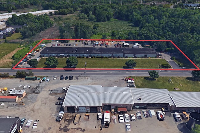
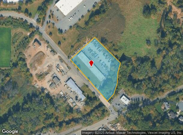
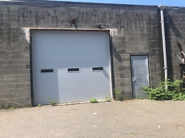
Property Record
7 Melanie Ln, East Hanover, NJ 07936
Current Lease Availabilities
NEARBY LISTINGS FOR SALE OR LEASE
Property Detail
7 Melanie Ln
Northern New Jersey
George & Melanie Deskovick
Newark, NJ-PA
Morris
10-00142-0000-00002-01
New Jersey
Commercialnec
2.1
2024
3.25 AC
2025
Eastern Morris
041902
DEMOGRAPHICS near 7 Melanie Ln
1 Mile
3 Mile
5 Mile
2024 Total Population
1,585
35,328
165,133
2029 Population
1,585
35,345
164,996
Pop Growth 2024-2029
0.00%
+ 0.05%
(0.08%)
Average Age
44
45
42
2024 Total Households
533
12,777
61,092
HH Growth 2024-2029
0.00%
0.00%
(0.05%)
Median Household Inc
$145,955
$145,493
$130,758
Avg Household Size
2.90
2.70
2.60
2024 Avg HH Vehicles
2.00
2.00
2.00
Median Home Value
$715,393
$680,530
$656,089
Median Year Built
1968
1977
1967
Nearby Places
- Restaurants
- Banks
- Shops
- Fitness
- Groceries
PUBLIC TRANSPORTATION
COMMUTER RAIL
Madison (Morris & Essex Morristown Line - NJ Transit Commuter Rail (NJ Transit))
DRIVE
WALK
Distance
Madison (Morris & Essex Morristown Line - NJ Transit Commuter Rail (NJ Transit))
11 min
5.0 mi
Convent Station (Morris & Essex Morristown Line - NJ Transit Commuter Rail (NJ Transit))
DRIVE
WALK
Distance
Convent Station (Morris & Essex Morristown Line - NJ Transit Commuter Rail (NJ Transit))
13 min
6.9 mi
AIRPORT
Newark Liberty International
DRIVE
WALK
Distance
Newark Liberty International
31 min
23.5 mi
LaGuardia
DRIVE
WALK
Distance
LaGuardia
58 min
40.4 mi
Freight Ports
Maher Terminal
DRIVE
WALK
Distance
Maher Terminal
34 min
24.0 mi
Nearby Properties
Address
Land Use
TOTAL SIZE
Lot Size
Zoning
Address
Land Use
TOTAL SIZE
Lot Size
Zoning
701 SF
111.59 AC
SED
Address
Land Use
TOTAL SIZE
Lot Size
Zoning
48.76 AC
OBRL
Address
Land Use
TOTAL SIZE
Lot Size
Zoning
596 SF
64.81 AC
OBRL
Address
Land Use
TOTAL SIZE
Lot Size
Zoning
64.80 AC
C-4
Address
Land Use
TOTAL SIZE
Lot Size
Zoning
9.80 AC
Address
Land Use
TOTAL SIZE
Lot Size
Zoning
41.19 AC
MF-C
Address
Land Use
TOTAL SIZE
Lot Size
Zoning
59,369 SF
86.79 AC
R-44
Address
Land Use
TOTAL SIZE
Lot Size
Zoning
13.10 AC
R-25
Address
Land Use
TOTAL SIZE
Lot Size
Zoning
147,871 SF
26.50 AC
PB-3
Address
Land Use
TOTAL SIZE
Lot Size
Zoning
20.97 AC
R-2
Address
Land Use
TOTAL SIZE
Lot Size
Zoning
60 AC
R-L
Address
Land Use
TOTAL SIZE
Lot Size
Zoning
46.46 AC
B-3
Address
Land Use
TOTAL SIZE
Lot Size
Zoning
58.20 AC
I
Address
Land Use
TOTAL SIZE
Lot Size
Zoning
11.80 AC
I/B
Address
Land Use
TOTAL SIZE
Lot Size
Zoning
336,832 SF
46.12 AC
R-L
Address
Land Use
TOTAL SIZE
Lot Size
Zoning
35.55 AC
P-B2
Address
Land Use
TOTAL SIZE
Lot Size
Zoning
49.53 AC
P
Address
Land Use
TOTAL SIZE
Lot Size
Zoning
25.40 AC
I-3
Address
Land Use
TOTAL SIZE
Lot Size
Zoning
5.35 AC
MF-6
Address
Land Use
TOTAL SIZE
Lot Size
Zoning
16.72 AC
C-3
Address
Land Use
TOTAL SIZE
Lot Size
Zoning
756 SF
16.46 AC
I
Address
Land Use
TOTAL SIZE
Lot Size
Zoning
43.15 AC
R-25
Address
Land Use
TOTAL SIZE
Lot Size
Zoning
Address
Land Use
TOTAL SIZE
Lot Size
Zoning
1,443 SF
165.75 AC
I-R2
Address
Land Use
TOTAL SIZE
Lot Size
Zoning
26.64 AC
C-1
Address
Land Use
TOTAL SIZE
Lot Size
Zoning
26,162 SF
72.70 AC
OSM
Address
Land Use
TOTAL SIZE
Lot Size
Zoning
14.76 AC
I/B
Address
Land Use
TOTAL SIZE
Lot Size
Zoning
97,771 SF
9.65 AC
C-I
Address
Land Use
TOTAL SIZE
Lot Size
Zoning
33.21 AC
C-5
Address
Land Use
TOTAL SIZE
Lot Size
Zoning
23.83 AC
R-15
The World's #1 Commercial Real Estate Marketplace
Connect with us
© 2025 CoStar Group
The information above has been obtained from sources believed reliable. While we do not doubt its accuracy we have not verified it and make no guarantee, warranty or representation about it. It is your responsibility to independently confirm its accuracy and completeness. Any projections, opinions, assumptions, or estimates used are for example only and do not represent the current or future performance of the property. The value of this transaction to you depends on tax and other factors which should be evaluated by your tax, financial, and legal advisors. You and your advisors should conduct a careful, independent investigation of the property to determine to your satisfaction the suitability of the property for your needs.