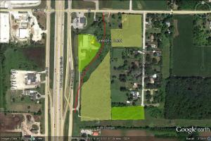
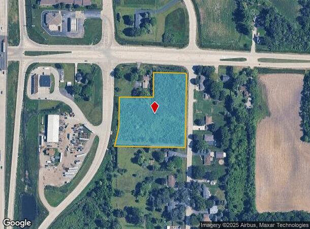
Property Record
7930 E Frontage Rd, Caledonia, WI 53108
NEARBY LISTINGS FOR SALE OR LEASE
Property Detail
7930 E Frontage Rd
104-042207053000
PT NW1/4 COM NW COR E1002 S69 TO POB S410 W399 NE106 N174 E194 N139 E180 SE11 TO POB PT TO 104042207107000 IN 2011 FOR 2012 R
Commercialacreage
Racine
X
Wisconsin
55101C0079D
3.05 AC
2024
Racine East
2024
Milwaukee/Madison
001601
Racine, WI
DEMOGRAPHICS near 7930 E Frontage Rd
1 Mile
3 Mile
5 Mile
2024 Total Population
363
6,312
35,645
2029 Population
354
6,147
34,781
Pop Growth 2024-2029
(2.48%)
(2.61%)
(2.42%)
Average Age
47
43
41
2024 Total Households
149
2,373
13,488
HH Growth 2024-2029
(2.68%)
(2.70%)
(2.54%)
Median Household Inc
$112,500
$106,738
$96,725
Avg Household Size
2.40
2.60
2.50
2024 Avg HH Vehicles
3.00
3.00
2.00
Median Home Value
$341,666
$299,930
$315,233
Median Year Built
1968
1990
1991
Nearby Places
Map Layers
Map Styles
 Street
 Aerial
- Restaurants
- Banks
- Shops
- Fitness
- Groceries
PUBLIC TRANSPORTATION
AIRPORT
General Mitchell International
DRIVE
WALK
Distance
General Mitchell International
15 min
10.2 mi
SALE & LEASE HISTORY
LISTING DATE
SALE/LEASE

Apr 21, 2020
For Sale
Nearby Properties
Address
Land Use
TOTAL SIZE
Lot Size
Zoning
Address
Land Use
TOTAL SIZE
Lot Size
Zoning
75.05 AC
Address
Land Use
TOTAL SIZE
Lot Size
Zoning
23.29 AC
Address
Land Use
TOTAL SIZE
Lot Size
Zoning
64,800 SF
28.17 AC
Address
Land Use
TOTAL SIZE
Lot Size
Zoning
21.59 AC
Address
Land Use
TOTAL SIZE
Lot Size
Zoning
48.65 AC
Address
Land Use
TOTAL SIZE
Lot Size
Zoning
17.37 AC
Address
Land Use
TOTAL SIZE
Lot Size
Zoning
28.04 AC
Address
Land Use
TOTAL SIZE
Lot Size
Zoning
19.25 AC
Address
Land Use
TOTAL SIZE
Lot Size
Zoning
26.03 AC
Address
Land Use
TOTAL SIZE
Lot Size
Zoning
42,253 SF
6.93 AC
Address
Land Use
TOTAL SIZE
Lot Size
Zoning
21.21 AC
Address
Land Use
TOTAL SIZE
Lot Size
Zoning
12.45 AC
Address
Land Use
TOTAL SIZE
Lot Size
Zoning
Address
Land Use
TOTAL SIZE
Lot Size
Zoning
16.25 AC
Address
Land Use
TOTAL SIZE
Lot Size
Zoning
12.31 AC
Address
Land Use
TOTAL SIZE
Lot Size
Zoning
Address
Land Use
TOTAL SIZE
Lot Size
Zoning
Address
Land Use
TOTAL SIZE
Lot Size
Zoning
13.05 AC
Address
Land Use
TOTAL SIZE
Lot Size
Zoning
95.21 AC
Address
Land Use
TOTAL SIZE
Lot Size
Zoning
411,369 SF
53.72 AC
Address
Land Use
TOTAL SIZE
Lot Size
Zoning
10.75 AC
Address
Land Use
TOTAL SIZE
Lot Size
Zoning
129,024 SF
7.61 AC
Address
Land Use
TOTAL SIZE
Lot Size
Zoning
Address
Land Use
TOTAL SIZE
Lot Size
Zoning
34.39 AC
Address
Land Use
TOTAL SIZE
Lot Size
Zoning
24.91 AC
Address
Land Use
TOTAL SIZE
Lot Size
Zoning
8.74 AC
Address
Land Use
TOTAL SIZE
Lot Size
Zoning
Address
Land Use
TOTAL SIZE
Lot Size
Zoning
Address
Land Use
TOTAL SIZE
Lot Size
Zoning
Address
Land Use
TOTAL SIZE
Lot Size
Zoning
12.08 AC
The World's #1 Commercial Real Estate Marketplace
Connect with us
© 2025 CoStar Group
The information above has been obtained from sources believed reliable. While we do not doubt its accuracy we have not verified it and make no guarantee, warranty or representation about it. It is your responsibility to independently confirm its accuracy and completeness. Any projections, opinions, assumptions, or estimates used are for example only and do not represent the current or future performance of the property. The value of this transaction to you depends on tax and other factors which should be evaluated by your tax, financial, and legal advisors. You and your advisors should conduct a careful, independent investigation of the property to determine to your satisfaction the suitability of the property for your needs.