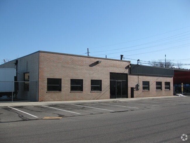
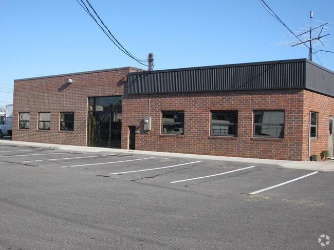
Property Record
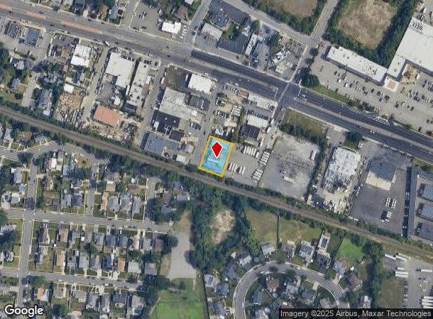
7 Murray St, Farmingdale, NY 11735

NEARBY LISTINGS FOR SALE OR LEASE
Property Detail
7 Murray St
Nassau County-Suffolk County, NY
FM 128 BL 6 LTS 160-166 INC
0100-070-00-01-00-017-000
Suffolk
Warehouse
New York
X
17
36103C0835H
0.32 AC
2024
East Farmingdale
2024
Long Island (New York)
520402
DEMOGRAPHICS near 7 Murray St
1 Mile
3 Mile
5 Mile
2024 Total Population
15,237
114,469
366,498
2029 Population
14,886
112,077
358,976
Pop Growth 2024-2029
(2.30%)
(2.09%)
(2.05%)
Average Age
43
41
42
2024 Total Households
5,709
37,388
120,425
HH Growth 2024-2029
(2.40%)
(2.25%)
(2.20%)
Median Household Inc
$112,523
$118,310
$122,015
Avg Household Size
2.60
2.90
2.90
2024 Avg HH Vehicles
2.00
2.00
2.00
Median Home Value
$482,076
$519,307
$541,301
Median Year Built
1957
1957
1957
Nearby Places
- Restaurants
- Banks
- Shops
- Fitness
- Groceries
PUBLIC TRANSPORTATION
COMMUTER RAIL
Farmingdale Station (Ronkonkoma Branch - Long Island Rail Road)
DRIVE
WALK
Distance
Farmingdale Station (Ronkonkoma Branch - Long Island Rail Road)
4 min
1.3 mi
Pinelawn Station (Ronkonkoma Branch - Long Island Rail Road)
DRIVE
WALK
Distance
Pinelawn Station (Ronkonkoma Branch - Long Island Rail Road)
7 min
3.2 mi
AIRPORT
Long Island MacArthur
DRIVE
WALK
Distance
Long Island MacArthur
31 min
22.0 mi
John F Kennedy International
DRIVE
WALK
Distance
John F Kennedy International
35 min
24.7 mi
LaGuardia
DRIVE
WALK
Distance
LaGuardia
45 min
31.7 mi
Freight Ports
NY - Red Hook Container Terminal
DRIVE
WALK
Distance
NY - Red Hook Container Terminal
56 min
36.1 mi
Nearby Properties
Address
Land Use
TOTAL SIZE
Lot Size
Zoning
Address
Land Use
TOTAL SIZE
Lot Size
Zoning
9.95 AC
BUS3
Address
Land Use
TOTAL SIZE
Lot Size
Zoning
892,140 SF
31.82 AC
Address
Land Use
TOTAL SIZE
Lot Size
Zoning
37 AC
I2
Address
Land Use
TOTAL SIZE
Lot Size
Zoning
24.90 AC
B
Address
Land Use
TOTAL SIZE
Lot Size
Zoning
116,514 SF
382 AC
Address
Land Use
TOTAL SIZE
Lot Size
Zoning
35,978 SF
375.68 AC
Address
Land Use
TOTAL SIZE
Lot Size
Zoning
1,945 SF
278.09 AC
Address
Land Use
TOTAL SIZE
Lot Size
Zoning
77,270 SF
21.67 AC
Address
Land Use
TOTAL SIZE
Lot Size
Zoning
Address
Land Use
TOTAL SIZE
Lot Size
Zoning
336,442 SF
43.50 AC
G
Address
Land Use
TOTAL SIZE
Lot Size
Zoning
288 SF
194.85 AC
Address
Land Use
TOTAL SIZE
Lot Size
Zoning
Address
Land Use
TOTAL SIZE
Lot Size
Zoning
22.10 AC
Address
Land Use
TOTAL SIZE
Lot Size
Zoning
7.15 AC
Address
Land Use
TOTAL SIZE
Lot Size
Zoning
3,951 SF
44.33 AC
Address
Land Use
TOTAL SIZE
Lot Size
Zoning
348,954 SF
9.98 AC
Address
Land Use
TOTAL SIZE
Lot Size
Zoning
13.63 AC
B
Address
Land Use
TOTAL SIZE
Lot Size
Zoning
52,750 SF
55.67 AC
Address
Land Use
TOTAL SIZE
Lot Size
Zoning
37.20 AC
I2
Address
Land Use
TOTAL SIZE
Lot Size
Zoning
68,555 SF
20.14 AC
Address
Land Use
TOTAL SIZE
Lot Size
Zoning
24.75 AC
R40
Address
Land Use
TOTAL SIZE
Lot Size
Zoning
183.15 AC
Address
Land Use
TOTAL SIZE
Lot Size
Zoning
177,845 SF
22.04 AC
Address
Land Use
TOTAL SIZE
Lot Size
Zoning
76,790 SF
19.32 AC
Address
Land Use
TOTAL SIZE
Lot Size
Zoning
136,804 SF
10.56 AC
Address
Land Use
TOTAL SIZE
Lot Size
Zoning
9.68 AC
SC
Address
Land Use
TOTAL SIZE
Lot Size
Zoning
74.90 AC
G
Address
Land Use
TOTAL SIZE
Lot Size
Zoning
157,191 SF
17.70 AC
G
Address
Land Use
TOTAL SIZE
Lot Size
Zoning
0.46 AC
R40
Address
Land Use
TOTAL SIZE
Lot Size
Zoning
292.40 AC
A
The World's #1 Commercial Real Estate Marketplace
Connect with us
© 2025 CoStar Group
The information above has been obtained from sources believed reliable. While we do not doubt its accuracy we have not verified it and make no guarantee, warranty or representation about it. It is your responsibility to independently confirm its accuracy and completeness. Any projections, opinions, assumptions, or estimates used are for example only and do not represent the current or future performance of the property. The value of this transaction to you depends on tax and other factors which should be evaluated by your tax, financial, and legal advisors. You and your advisors should conduct a careful, independent investigation of the property to determine to your satisfaction the suitability of the property for your needs.