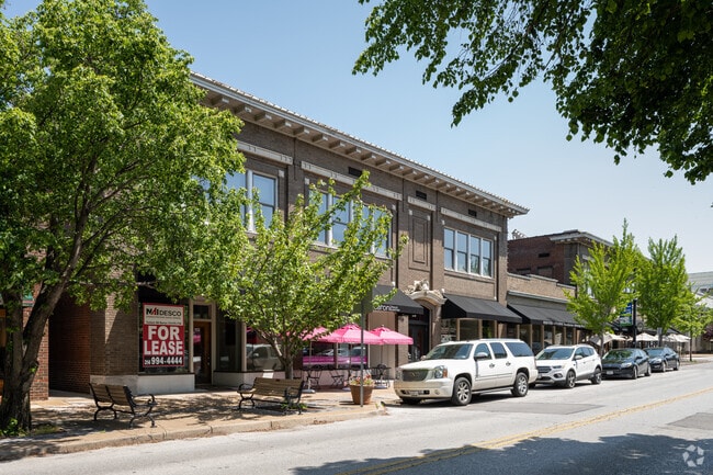
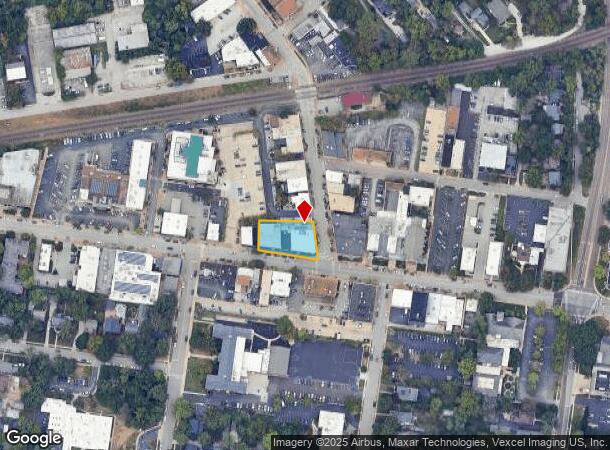
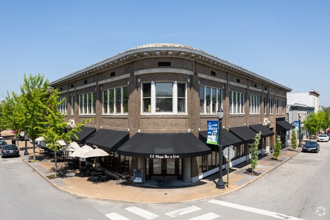
Property Record
7 N Gore Ave, Saint Louis, MO 63119

Current Lease Availabilities
NEARBY LISTINGS FOR SALE OR LEASE
Property Detail
7 N Gore Ave
St. Louis, MO-IL
Webster Groves
23K-43-0817
WEBSTER GROVES LOT PT 8 SE PART LOC AT NW COR LOCKWOOD AVE & GORE AVE
Storebuilding
St. Louis
X
Missouri
29189C0328K
8
2024
0.42 AC
2025
Mid County
219300
St. Louis
35,921 SF
DEMOGRAPHICS near 7 N Gore Ave
1 Mile
3 Mile
5 Mile
2024 Total Population
11,918
97,819
265,302
2029 Population
11,830
95,369
256,378
Pop Growth 2024-2029
(0.74%)
(2.50%)
(3.36%)
Average Age
39
41
41
2024 Total Households
4,313
43,128
117,805
HH Growth 2024-2029
(0.90%)
(2.65%)
(3.60%)
Median Household Inc
$119,592
$88,825
$85,271
Avg Household Size
2.50
2.20
2.20
2024 Avg HH Vehicles
2.00
2.00
2.00
Median Home Value
$403,931
$319,552
$291,116
Median Year Built
1949
1955
1954
Nearby Places
Map Layers
Map Styles
 Street
 Aerial
- Restaurants
- Banks
- Shops
- Fitness
- Groceries
PUBLIC TRANSPORTATION
COMMUTER RAIL
Sunnen (Shrewsbury-Lansdowne I-44 Emerson Park - St. Louis MetroLink (MetroLink))
DRIVE
WALK
Distance
Sunnen (Shrewsbury-Lansdowne I-44 Emerson Park - St. Louis MetroLink (MetroLink))
5 min
2.6 mi
Maplewood-Manchester (Shrewsbury-Lansdowne I-44 Emerson Park - St. Louis MetroLink (MetroLink))
DRIVE
WALK
Distance
Maplewood-Manchester (Shrewsbury-Lansdowne I-44 Emerson Park - St. Louis MetroLink (MetroLink))
6 min
3.1 mi
AIRPORT
St Louis Lambert International
DRIVE
WALK
Distance
St Louis Lambert International
20 min
13.1 mi
Scott AFB/Midamerica St Louis
DRIVE
WALK
Distance
Scott AFB/Midamerica St Louis
54 min
35.6 mi
Freight Ports
Port Milwaukee
DRIVE
WALK
Distance
Port Milwaukee
433 min
379.9 mi
Nearby Properties
Address
Land Use
TOTAL SIZE
Lot Size
Zoning
Address
Land Use
TOTAL SIZE
Lot Size
Zoning
844,350 SF
63.08 AC
64A1
Address
Land Use
TOTAL SIZE
Lot Size
Zoning
178,963 SF
14.98 AC
E
Address
Land Use
TOTAL SIZE
Lot Size
Zoning
559,752 SF
24.37 AC
53R-3
Address
Land Use
TOTAL SIZE
Lot Size
Zoning
322,742 SF
15.04 AC
9LID
Address
Land Use
TOTAL SIZE
Lot Size
Zoning
175,698 SF
15.92 AC
9PD
Address
Land Use
TOTAL SIZE
Lot Size
Zoning
389,475 SF
27.55 AC
D
Address
Land Use
TOTAL SIZE
Lot Size
Zoning
172,157 SF
1.43 AC
9RSC
Address
Land Use
TOTAL SIZE
Lot Size
Zoning
531,347 SF
5.36 AC
49PDC
Address
Land Use
TOTAL SIZE
Lot Size
Zoning
323,288 SF
7.16 AC
C
Address
Land Use
TOTAL SIZE
Lot Size
Zoning
212,406 SF
21.42 AC
AB
Address
Land Use
TOTAL SIZE
Lot Size
Zoning
198,556 SF
10.12 AC
A
Address
Land Use
TOTAL SIZE
Lot Size
Zoning
96,804 SF
1.38 AC
49PDC
Address
Land Use
TOTAL SIZE
Lot Size
Zoning
44.38 AC
R1
Address
Land Use
TOTAL SIZE
Lot Size
Zoning
187,188 SF
6.83 AC
G
Address
Land Use
TOTAL SIZE
Lot Size
Zoning
158,767 SF
17.01 AC
64A3
Address
Land Use
TOTAL SIZE
Lot Size
Zoning
39,712 SF
30.49 AC
R1
Address
Land Use
TOTAL SIZE
Lot Size
Zoning
3,024 SF
4.73 AC
64A3
Address
Land Use
TOTAL SIZE
Lot Size
Zoning
3,578 SF
24.57 AC
R3
Address
Land Use
TOTAL SIZE
Lot Size
Zoning
8,981 SF
10.81 AC
64A3
Address
Land Use
TOTAL SIZE
Lot Size
Zoning
227,634 SF
11.28 AC
49C2
Address
Land Use
TOTAL SIZE
Lot Size
Zoning
396 SF
8.57 AC
69M-1
Address
Land Use
TOTAL SIZE
Lot Size
Zoning
27,679 SF
2.56 AC
32B2
Address
Land Use
TOTAL SIZE
Lot Size
Zoning
206,280 SF
2.85 AC
9PD
Address
Land Use
TOTAL SIZE
Lot Size
Zoning
48,236 SF
16.23 AC
64A1
Address
Land Use
TOTAL SIZE
Lot Size
Zoning
113,453 SF
3.10 AC
9PD
Address
Land Use
TOTAL SIZE
Lot Size
Zoning
1,176 SF
11.19 AC
64A3
Address
Land Use
TOTAL SIZE
Lot Size
Zoning
375,783 SF
15.42 AC
37MULTI
Address
Land Use
TOTAL SIZE
Lot Size
Zoning
1,512 SF
23.22 AC
41SP
Address
Land Use
TOTAL SIZE
Lot Size
Zoning
22.67 AC
PCD
Address
Land Use
TOTAL SIZE
Lot Size
Zoning
106,148 SF
13.01 AC
53C-2
The World's #1 Commercial Real Estate Marketplace
Connect with us
© 2026 CoStar Group
The information above has been obtained from sources believed reliable. While we do not doubt its accuracy we have not verified it and make no guarantee, warranty or representation about it. It is your responsibility to independently confirm its accuracy and completeness. Any projections, opinions, assumptions, or estimates used are for example only and do not represent the current or future performance of the property. The value of this transaction to you depends on tax and other factors which should be evaluated by your tax, financial, and legal advisors. You and your advisors should conduct a careful, independent investigation of the property to determine to your satisfaction the suitability of the property for your needs.