Property Record
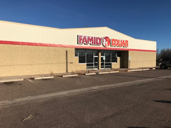
7 N Main St, Taylor, AZ 85939

Property Detail
7 N Main St
205-06-025
WEST TAYLOR: LOT 21
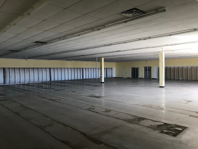
Storemultistory
Navajo
MUNICIPAL
Arizona
B and X Area of moderate flood hazard, usually the area between the limits of the 100-year and 500-year floods.
21
2024
0.65 AC
2026
Arizona Northeast & Holbrook Area
963400
Other Market Areas
7,202 SF
Show Low, AZ
NEARBY LISTINGS FOR SALE OR LEASE
-
-
View all Taylor listings for sale on LoopNet.com
DEMOGRAPHICS near 7 N Main St
1 mile
3 mile
5 mile
2025 Total Population
2,078
5,653
9,394
2030 Population
2,019
5,646
9,441
Pop Growth 2025-2030
(2.84%)
(0.12%)
+ 0.50%
Average Age
37
37
37
2025 Total Households
654
1,774
2,980
HH Growth 2025-2030
(3.98%)
(0.73%)
+ 0.07%
Median Household Inc
$69,146
$67,317
$66,558
Avg Household Size
3.00
3.10
3.10
2025 Avg HH Vehicles
3.00
2.00
2.00
Median Home Value
$325,568
$311,058
$309,768
Median Year Built
2000
1993
1993
Nearby Places
Map Layers
Map Styles
 Street
 Aerial
Transit
 Traffic
 Biking
Places
Listings with unknown addresses are not visible on the map
- Restaurants
- Banks
- Shops
- Fitness
- Groceries
SALE & LEASE HISTORY
LISTING DATE
SALE/LEASE

Mar 01, 2018
For Sale
Nearby Properties
Address
Land Use
TOTAL SIZE
Lot Size
Zoning
Address
Land Use
TOTAL SIZE
Lot Size
Zoning
104,708 SF
13.73 AC
MUNICIPAL
Address
Land Use
TOTAL SIZE
Lot Size
Zoning
46,607 SF
6.20 AC
MUNICIPAL
Address
Land Use
TOTAL SIZE
Lot Size
Zoning
16,267 SF
3.85 AC
MUNICIPAL
Address
Land Use
TOTAL SIZE
Lot Size
Zoning
47,830 SF
17.99 AC
MUNICIPAL
Address
Land Use
TOTAL SIZE
Lot Size
Zoning
52,140 SF
7.10 AC
MUNICIPAL
Address
Land Use
TOTAL SIZE
Lot Size
Zoning
23,805 SF
4.57 AC
MUNICIPAL
Address
Land Use
TOTAL SIZE
Lot Size
Zoning
9,294 SF
13.63 AC
MUNICIPAL
Address
Land Use
TOTAL SIZE
Lot Size
Zoning
18,300 SF
3.78 AC
MUNICIPAL
Address
Land Use
TOTAL SIZE
Lot Size
Zoning
18,993 SF
1.74 AC
MUNICIPAL
Address
Land Use
TOTAL SIZE
Lot Size
Zoning
31,598 SF
2 AC
MUNICIPAL
Address
Land Use
TOTAL SIZE
Lot Size
Zoning
23,257 SF
4.05 AC
MUNICIPAL
Address
Land Use
TOTAL SIZE
Lot Size
Zoning
10,960 SF
1.65 AC
MUNICIPAL
Address
Land Use
TOTAL SIZE
Lot Size
Zoning
36,480 SF
5.13 AC
MUNICIPAL
Address
Land Use
TOTAL SIZE
Lot Size
Zoning
28,300 SF
1.89 AC
MUNICIPAL
Address
Land Use
TOTAL SIZE
Lot Size
Zoning
9,677 SF
4.49 AC
MUNICIPAL
Address
Land Use
TOTAL SIZE
Lot Size
Zoning
5,875 SF
1.45 AC
MUNICIPAL
Address
Land Use
TOTAL SIZE
Lot Size
Zoning
10,776 SF
1.74 AC
MUNICIPAL
Address
Land Use
TOTAL SIZE
Lot Size
Zoning
7,300 SF
1.69 AC
MUNICIPAL
Address
Land Use
TOTAL SIZE
Lot Size
Zoning
35,690 SF
3.05 AC
MUNICIPAL
Address
Land Use
TOTAL SIZE
Lot Size
Zoning
8,640 SF
2.09 AC
MUNICIPAL
Address
Land Use
TOTAL SIZE
Lot Size
Zoning
7,500 SF
18.50 AC
MUNICIPAL
Address
Land Use
TOTAL SIZE
Lot Size
Zoning
9,600 SF
1.48 AC
MUNICIPAL
Address
Land Use
TOTAL SIZE
Lot Size
Zoning
19,324 SF
1.64 AC
MUNICIPAL
Address
Land Use
TOTAL SIZE
Lot Size
Zoning
17,083 SF
2.23 AC
MUNICIPAL
Address
Land Use
TOTAL SIZE
Lot Size
Zoning
2,868 SF
1.63 AC
MUNICIPAL
Address
Land Use
TOTAL SIZE
Lot Size
Zoning
5,598 SF
0.45 AC
MUNICIPAL
Address
Land Use
TOTAL SIZE
Lot Size
Zoning
13,144 SF
0.81 AC
MUNICIPAL
Address
Land Use
TOTAL SIZE
Lot Size
Zoning
5,910 SF
1.61 AC
MUNICIPAL
Address
Land Use
TOTAL SIZE
Lot Size
Zoning
15,560 SF
1.07 AC
MUNICIPAL
Address
Land Use
TOTAL SIZE
Lot Size
Zoning
7,252 SF
6.20 AC
MUNICIPAL
The World's #1 Commercial Real Estate Marketplace
Connect with us
© 2026 CoStar Group
The information above has been obtained from sources believed reliable. While we do not doubt its accuracy we have not verified it and make no guarantee, warranty or representation about it. It is your responsibility to independently confirm its accuracy and completeness. Any projections, opinions, assumptions, or estimates used are for example only and do not represent the current or future performance of the property. The value of this transaction to you depends on tax and other factors which should be evaluated by your tax, financial, and legal advisors. You and your advisors should conduct a careful, independent investigation of the property to determine to your satisfaction the suitability of the property for your needs.