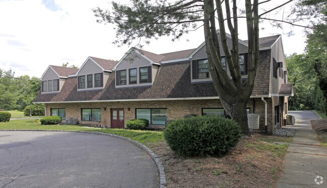
Property Record
7 Oak Ridge Rd, Newfoundland, NJ 07435


Save to a Folder
{{folder.Name}}
{{folder.ListingIds.length}} Properties
{{folder.ListingIds.length}} Property
Create a New Folder
Property Detail
7 Oak Ridge Rd
New York-Jersey City-White Plains, NY-NJ
Passaic
15-15804-0000-00012
New Jersey
Commercialnec
12
AE The base floodplain where base flood elevations are provided. AE Zones are now used on new format FIRMs instead of A1-A30 Zones.
1.34 AC
2025
Upper Suburban Passaic
2026
Northern New Jersey
124311
NEARBY LISTINGS FOR SALE OR LEASE
-
-
View all Newfoundland listings for lease on LoopNet.com
DEMOGRAPHICS near 7 Oak Ridge Rd
1 mile
3 mile
5 mile
2025 Total Population
1,237
6,324
24,605
2030 Population
1,274
6,533
25,499
Pop Growth 2025-2030
+ 2.99%
+ 3.30%
+ 3.63%
Average Age
43
43
43
2025 Total Households
441
2,303
9,004
HH Growth 2025-2030
+ 2.72%
+ 3.34%
+ 3.67%
Median Household Inc
$123,912
$123,234
$132,066
Avg Household Size
2.80
2.70
2.70
2025 Avg HH Vehicles
2.00
2.00
2.00
Median Home Value
$448,742
$456,750
$446,931
Median Year Built
1968
1976
1971
Nearby Places
Map Layers
Map Styles
 Street
 Aerial
Layers
 Traffic
 Biking
Places
Listings with unknown addresses are not visible on the map
- Restaurants
- Banks
- Shops
- Fitness
- Groceries
PUBLIC TRANSPORTATION
AIRPORT
Newark Liberty International
Drive
Walk
Distance
Newark Liberty International
46 min
38.7 mi
LaGuardia
Drive
Walk
Distance
LaGuardia
62 min
46.7 mi
Freight Ports
Maher Terminal
Drive
Walk
Distance
Maher Terminal
53 min
38.6 mi
SALE & LEASE HISTORY
LISTING DATE
SALE/LEASE

Sep 25, 2016
For Lease
Jan 28, 2025
For Lease
Nearby Properties
Address
Land Use
TOTAL SIZE
Lot Size
Zoning
Address
Land Use
TOTAL SIZE
Lot Size
Zoning
15.53 AC
C-1
Address
Land Use
TOTAL SIZE
Lot Size
Zoning
2,372.35 AC
RC
Address
Land Use
TOTAL SIZE
Lot Size
Zoning
493.70 AC
R
Address
Land Use
TOTAL SIZE
Lot Size
Zoning
7,836 SF
19.11 AC
B-1
Address
Land Use
TOTAL SIZE
Lot Size
Zoning
6.63 AC
C-1
Address
Land Use
TOTAL SIZE
Lot Size
Zoning
5 AC
R-44
Address
Land Use
TOTAL SIZE
Lot Size
Zoning
1,920.40 AC
Address
Land Use
TOTAL SIZE
Lot Size
Zoning
Address
Land Use
TOTAL SIZE
Lot Size
Zoning
1,788.04 AC
Address
Land Use
TOTAL SIZE
Lot Size
Zoning
3,600 SF
1.27 AC
C-1
Address
Land Use
TOTAL SIZE
Lot Size
Zoning
9,093 SF
9.87 AC
B-1
Address
Land Use
TOTAL SIZE
Lot Size
Zoning
1,012.20 AC
RC
Address
Land Use
TOTAL SIZE
Lot Size
Zoning
1,117.99 AC
Address
Land Use
TOTAL SIZE
Lot Size
Zoning
10.40 AC
C-1
Address
Land Use
TOTAL SIZE
Lot Size
Zoning
2,914 SF
4.23 AC
Address
Land Use
TOTAL SIZE
Lot Size
Zoning
965.60 AC
R20A
Address
Land Use
TOTAL SIZE
Lot Size
Zoning
Address
Land Use
TOTAL SIZE
Lot Size
Zoning
3.34 AC
Address
Land Use
TOTAL SIZE
Lot Size
Zoning
10.07 AC
Address
Land Use
TOTAL SIZE
Lot Size
Zoning
9,180 SF
1.10 AC
C-1
Address
Land Use
TOTAL SIZE
Lot Size
Zoning
2,002 SF
8.39 AC
Address
Land Use
TOTAL SIZE
Lot Size
Zoning
Address
Land Use
TOTAL SIZE
Lot Size
Zoning
12,180 SF
11.10 AC
O
Address
Land Use
TOTAL SIZE
Lot Size
Zoning
3,544 SF
1.70 AC
R-13
Address
Land Use
TOTAL SIZE
Lot Size
Zoning
Address
Land Use
TOTAL SIZE
Lot Size
Zoning
1.90 AC
Address
Land Use
TOTAL SIZE
Lot Size
Zoning
553.75 AC
Address
Land Use
TOTAL SIZE
Lot Size
Zoning
3.39 AC
Address
Land Use
TOTAL SIZE
Lot Size
Zoning
10,800 SF
0.94 AC
C-1
Address
Land Use
TOTAL SIZE
Lot Size
Zoning
10,700 SF
22.44 AC
IP
The World's #1 Commercial Real Estate Marketplace
Connect with us
© 2026 CoStar Group
The information above has been obtained from sources believed reliable. While we do not doubt its accuracy we have not verified it and make no guarantee, warranty or representation about it. It is your responsibility to independently confirm its accuracy and completeness. Any projections, opinions, assumptions, or estimates used are for example only and do not represent the current or future performance of the property. The value of this transaction to you depends on tax and other factors which should be evaluated by your tax, financial, and legal advisors. You and your advisors should conduct a careful, independent investigation of the property to determine to your satisfaction the suitability of the property for your needs.