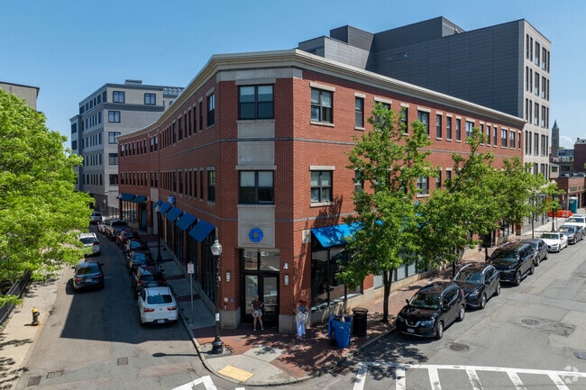
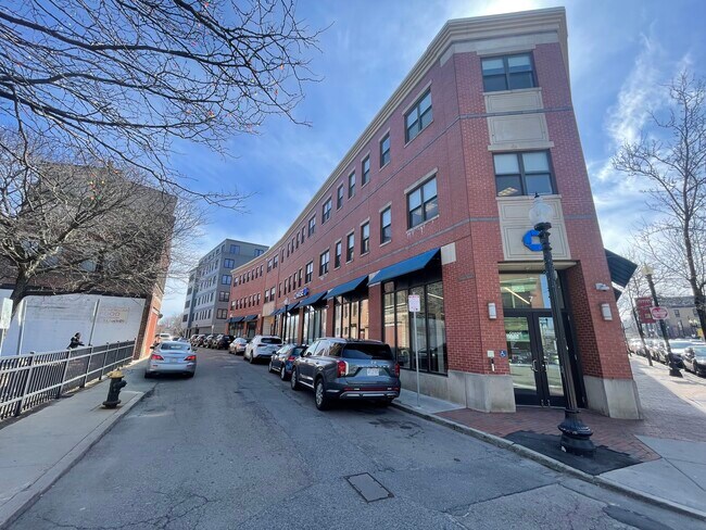
Property Record
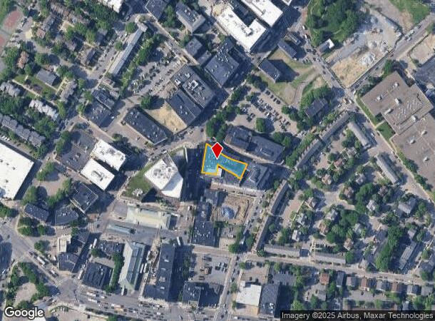
2 Warren St, Roxbury, MA 02119
NEARBY LISTINGS FOR SALE OR LEASE
Property Detail
2 Warren St
Officebuilding
Suffolk
X
Massachusetts
25025C0079J
0.30 AC
2025
Roxbury/Dorchester
2025
Boston
080401
Boston-Cambridge-Newton, MA-NH
34,360 SF
ROXB-000000-000008-002533-000010
DEMOGRAPHICS near 2 Warren St
1 mile
3 mile
5 mile
2024 Total Population
78,367
493,804
877,852
2029 Population
75,096
476,023
845,465
Pop Growth 2024-2029
(4.17%)
(3.60%)
(3.69%)
Average Age
35
36
37
2024 Total Households
28,590
209,931
366,511
HH Growth 2024-2029
(4.59%)
(3.81%)
(3.93%)
Median Household Inc
$46,083
$86,396
$92,104
Avg Household Size
2.10
2.10
2.20
2024 Avg HH Vehicles
1.00
1.00
1.00
Median Home Value
$796,895
$847,780
$795,321
Median Year Built
1950
1953
1949
Nearby Places
Map Layers
Map Styles
 Street
 Aerial
Transit
 Traffic
 Biking
Places
Listings with unknown addresses are not visible on the map
- Restaurants
- Banks
- Shops
- Fitness
- Groceries
PUBLIC TRANSPORTATION
TRANSIT/SUBWAY
Roxbury Crossing Station (Orange Line - Massachusetts Bay Transportation Authority Subway (The T))
Drive
Walk
Distance
Roxbury Crossing Station (Orange Line - Massachusetts Bay Transportation Authority Subway (The T))
2 min
15 min
0.8 mi
Northeastern University Station (Green Line - E - Massachusetts Bay Transportation Authority Subway (The T))
Drive
Walk
Distance
Northeastern University Station (Green Line - E - Massachusetts Bay Transportation Authority Subway (The T))
4 min
16 min
0.9 mi
Massachusetts Ave Station (Orange Line) (Orange Line - Massachusetts Bay Transportation Authority Subway (The T))
Drive
Walk
Distance
Massachusetts Ave Station (Orange Line) (Orange Line - Massachusetts Bay Transportation Authority Subway (The T))
4 min
17 min
0.9 mi
Museum Of Fine Arts Station (Green Line - E - Massachusetts Bay Transportation Authority Subway (The T))
Drive
Walk
Distance
Museum Of Fine Arts Station (Green Line - E - Massachusetts Bay Transportation Authority Subway (The T))
3 min
18 min
0.9 mi
Symphony Station (Green Line - E - Massachusetts Bay Transportation Authority Subway (The T))
Drive
Walk
Distance
Symphony Station (Green Line - E - Massachusetts Bay Transportation Authority Subway (The T))
4 min
20 min
1.1 mi
COMMUTER RAIL
Ruggles Station (Franklin Line - Massachusetts Bay Transportation Authority Commuter Rail (Purple Line), Needham Line - Massachusetts Bay Transportation Authority Commuter Rail (Purple Line), Orange Line - Massachusetts Bay Transportation Authority Commuter Rail (Purple Line), Providence/Stoughton Line - Massachusetts Bay Transportation Authority Commuter Rail (Purple Line))
Drive
Walk
Distance
Ruggles Station (Franklin Line - Massachusetts Bay Transportation Authority Commuter Rail (Purple Line), Needham Line - Massachusetts Bay Transportation Authority Commuter Rail (Purple Line), Orange Line - Massachusetts Bay Transportation Authority Commuter Rail (Purple Line), Providence/Stoughton Line - Massachusetts Bay Transportation Authority Commuter Rail (Purple Line))
4 min
13 min
0.7 mi
Newmarket (Fairmount Line - MBTA, Franklin/Foxboro Line - MBTA)
Drive
Walk
Distance
Newmarket (Fairmount Line - MBTA, Franklin/Foxboro Line - MBTA)
2 min
1.2 mi
AIRPORT
General Edward Lawrence Logan International
Drive
Walk
Distance
General Edward Lawrence Logan International
11 min
5.6 mi
Freight Ports
Port of Boston
Drive
Walk
Distance
Port of Boston
9 min
3.9 mi
Nearby Properties
Address
Land Use
TOTAL SIZE
Lot Size
Zoning
Address
Land Use
TOTAL SIZE
Lot Size
Zoning
909,764 SF
25.13 AC
E
Address
Land Use
TOTAL SIZE
Lot Size
Zoning
610,560 SF
4.01 AC
E
Address
Land Use
TOTAL SIZE
Lot Size
Zoning
408,667 SF
3.27 AC
C
Address
Land Use
TOTAL SIZE
Lot Size
Zoning
825,000 SF
5.17 AC
E
Address
Land Use
TOTAL SIZE
Lot Size
Zoning
6.39 AC
C
Address
Land Use
TOTAL SIZE
Lot Size
Zoning
596,972 SF
7.32 AC
E
Address
Land Use
TOTAL SIZE
Lot Size
Zoning
173,400 SF
1.14 AC
MXD
Address
Land Use
TOTAL SIZE
Lot Size
Zoning
334,522 SF
1.26 AC
C
Address
Land Use
TOTAL SIZE
Lot Size
Zoning
312,269 SF
0.43 AC
C
Address
Land Use
TOTAL SIZE
Lot Size
Zoning
230,394 SF
0.60 AC
MXD
Address
Land Use
TOTAL SIZE
Lot Size
Zoning
46,259 SF
1.05 AC
E
Address
Land Use
TOTAL SIZE
Lot Size
Zoning
118,759 SF
0.92 AC
C
Address
Land Use
TOTAL SIZE
Lot Size
Zoning
3.52 AC
C-3
Address
Land Use
TOTAL SIZE
Lot Size
Zoning
377,634 SF
4.86 AC
E
Address
Land Use
TOTAL SIZE
Lot Size
Zoning
1.13 AC
C
Address
Land Use
TOTAL SIZE
Lot Size
Zoning
239,377 SF
0.71 AC
MXD
Address
Land Use
TOTAL SIZE
Lot Size
Zoning
3.75 AC
C
Address
Land Use
TOTAL SIZE
Lot Size
Zoning
227,107 SF
7.70 AC
E
Address
Land Use
TOTAL SIZE
Lot Size
Zoning
2.81 AC
O-2
Address
Land Use
TOTAL SIZE
Lot Size
Zoning
448,796 SF
1.84 AC
C
Address
Land Use
TOTAL SIZE
Lot Size
Zoning
254,208 SF
3.83 AC
E
Address
Land Use
TOTAL SIZE
Lot Size
Zoning
341,500 SF
1.18 AC
RC
Address
Land Use
TOTAL SIZE
Lot Size
Zoning
252,392 SF
0.52 AC
C
Address
Land Use
TOTAL SIZE
Lot Size
Zoning
262,120 SF
0.62 AC
C
Address
Land Use
TOTAL SIZE
Lot Size
Zoning
325,020 SF
0.62 AC
RC
Address
Land Use
TOTAL SIZE
Lot Size
Zoning
237,935 SF
1.27 AC
C-3
Address
Land Use
TOTAL SIZE
Lot Size
Zoning
619,050 SF
0.45 AC
C
Address
Land Use
TOTAL SIZE
Lot Size
Zoning
259,990 SF
2.84 AC
E
Address
Land Use
TOTAL SIZE
Lot Size
Zoning
6.14 AC
C
Address
Land Use
TOTAL SIZE
Lot Size
Zoning
547,851 SF
8.14 AC
E
The World's #1 Commercial Real Estate Marketplace
Connect with us
© 2026 CoStar Group
The information above has been obtained from sources believed reliable. While we do not doubt its accuracy we have not verified it and make no guarantee, warranty or representation about it. It is your responsibility to independently confirm its accuracy and completeness. Any projections, opinions, assumptions, or estimates used are for example only and do not represent the current or future performance of the property. The value of this transaction to you depends on tax and other factors which should be evaluated by your tax, financial, and legal advisors. You and your advisors should conduct a careful, independent investigation of the property to determine to your satisfaction the suitability of the property for your needs.