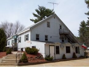
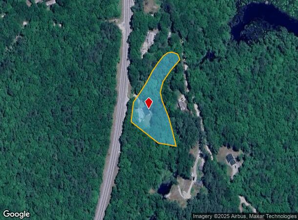
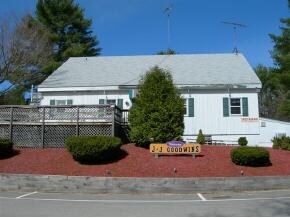
Property Record
7 Pineo Rd, Center Barnstead, NH 03225
NEARBY LISTINGS FOR SALE OR LEASE
-
-
View all Center Barnstead listings for sale on LoopNet.com
Property Detail
7 Pineo Rd
Other Market Areas
Belknap
Laconia, NH
New Hampshire
BRND-000010-000000-000039
2.11 AC
Sfr
Concord/New Hampshire North Area
1,576 SF
DEMOGRAPHICS near 7 Pineo Rd
1 Mile
3 Mile
5 Mile
2024 Total Population
542
4,443
7,497
2029 Population
568
4,613
7,750
Pop Growth 2024-2029
+ 4.80%
+ 3.83%
+ 3.37%
Average Age
43
42
43
2024 Total Households
214
1,721
2,893
HH Growth 2024-2029
+ 4.21%
+ 3.60%
+ 3.15%
Median Household Inc
$90,725
$84,035
$83,868
Avg Household Size
2.50
2.60
2.60
2024 Avg HH Vehicles
2.00
2.00
2.00
Median Home Value
$280,555
$274,427
$282,744
Median Year Built
1978
1980
1981
Nearby Places
Map Layers
Map Styles
 Street
 Aerial
- Restaurants
- Banks
- Shops
- Fitness
- Groceries
PUBLIC TRANSPORTATION
AIRPORT
Portsmouth International at Pease
DRIVE
WALK
Distance
Portsmouth International at Pease
62 min
34.8 mi
Manchester Boston Regional
DRIVE
WALK
Distance
Manchester Boston Regional
67 min
39.9 mi
Nearby Properties
Address
Land Use
TOTAL SIZE
Lot Size
Zoning
Address
Land Use
TOTAL SIZE
Lot Size
Zoning
2,000 SF
23.72 AC
101 RE
Address
Land Use
TOTAL SIZE
Lot Size
Zoning
49,314 SF
21.44 AC
101 RE
Address
Land Use
TOTAL SIZE
Lot Size
Zoning
99.50 AC
204 U
Address
Land Use
TOTAL SIZE
Lot Size
Zoning
5,686 SF
0.96 AC
LR-LAK
Address
Land Use
TOTAL SIZE
Lot Size
Zoning
109.85 AC
101 RE
Address
Land Use
TOTAL SIZE
Lot Size
Zoning
864 SF
16.50 AC
205 L
Address
Land Use
TOTAL SIZE
Lot Size
Zoning
5,788 SF
64 AC
RU-RUR
Address
Land Use
TOTAL SIZE
Lot Size
Zoning
9,422 SF
1.75 AC
301 CO
Address
Land Use
TOTAL SIZE
Lot Size
Zoning
2,242 SF
42 AC
RU-RUR
Address
Land Use
TOTAL SIZE
Lot Size
Zoning
517 SF
179 AC
204 U
Address
Land Use
TOTAL SIZE
Lot Size
Zoning
5.32 AC
205 L
Address
Land Use
TOTAL SIZE
Lot Size
Zoning
55 AC
207 HU
Address
Land Use
TOTAL SIZE
Lot Size
Zoning
5,082 SF
4.27 AC
400 VI
Address
Land Use
TOTAL SIZE
Lot Size
Zoning
1.16 AC
301 CO
Address
Land Use
TOTAL SIZE
Lot Size
Zoning
5,960 SF
0.51 AC
400 VI
Address
Land Use
TOTAL SIZE
Lot Size
Zoning
32 AC
204 U
Address
Land Use
TOTAL SIZE
Lot Size
Zoning
3,247 SF
1.75 AC
301 CO
Address
Land Use
TOTAL SIZE
Lot Size
Zoning
3,918 SF
6 AC
101 RE
Address
Land Use
TOTAL SIZE
Lot Size
Zoning
0.42 AC
209 HA
Address
Land Use
TOTAL SIZE
Lot Size
Zoning
4.60 AC
205 L
Address
Land Use
TOTAL SIZE
Lot Size
Zoning
3,376 SF
2.51 AC
101 RE
Address
Land Use
TOTAL SIZE
Lot Size
Zoning
4,286 SF
6.35 AC
101 RE
Address
Land Use
TOTAL SIZE
Lot Size
Zoning
5,031 SF
1.36 AC
400 VI
Address
Land Use
TOTAL SIZE
Lot Size
Zoning
0.17 AC
205 L
Address
Land Use
TOTAL SIZE
Lot Size
Zoning
1,753 SF
112 AC
101 RE
Address
Land Use
TOTAL SIZE
Lot Size
Zoning
2,978 SF
18.64 AC
101 RE
Address
Land Use
TOTAL SIZE
Lot Size
Zoning
3,359 SF
11 AC
101 RE
Address
Land Use
TOTAL SIZE
Lot Size
Zoning
3,308 SF
0.27 AC
400 VI
Address
Land Use
TOTAL SIZE
Lot Size
Zoning
1 AC
203 SU
Address
Land Use
TOTAL SIZE
Lot Size
Zoning
2,910 SF
2.60 AC
101 RE
The World's #1 Commercial Real Estate Marketplace
Connect with us
© 2026 CoStar Group
The information above has been obtained from sources believed reliable. While we do not doubt its accuracy we have not verified it and make no guarantee, warranty or representation about it. It is your responsibility to independently confirm its accuracy and completeness. Any projections, opinions, assumptions, or estimates used are for example only and do not represent the current or future performance of the property. The value of this transaction to you depends on tax and other factors which should be evaluated by your tax, financial, and legal advisors. You and your advisors should conduct a careful, independent investigation of the property to determine to your satisfaction the suitability of the property for your needs.