Property Record
880 Kingsdale Rd, Steubenville, OH 43952
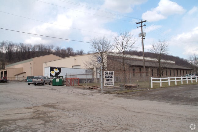

Property Detail
880 Kingsdale Rd
11-03844-000
1-3-32 6-LAND 1.724A MAP-11-3200-10600
Manufacturinglight
JEFFERSON
B and X Area of moderate flood hazard, usually the area between the limits of the 100-year and 500-year floods.
Ohio
2024
1.72 AC
2024
Ohio North Area
001400
Other Market Areas
16,720 SF
Weirton-Steubenville, WV-OH
NEARBY LISTINGS FOR SALE OR LEASE
DEMOGRAPHICS near 880 Kingsdale Rd
1 mile
3 mile
5 mile
2025 Total Population
2,016
24,208
49,991
2030 Population
1,948
23,733
48,874
Pop Growth 2025-2030
(3.37%)
(1.96%)
(2.23%)
Average Age
43
41
43
2025 Total Households
882
9,827
21,128
HH Growth 2025-2030
(3.51%)
(2.22%)
(2.43%)
Median Household Inc
$61,019
$46,829
$52,426
Avg Household Size
2.30
2.20
2.20
2025 Avg HH Vehicles
2.00
2.00
2.00
Median Home Value
$140,085
$121,022
$131,621
Median Year Built
1954
1954
1957
Nearby Places
Map Layers
Map Styles
 Street
 Aerial
Transit
 Traffic
 Biking
Places
Listings with unknown addresses are not visible on the map
- Restaurants
- Banks
- Shops
- Fitness
- Groceries
PUBLIC TRANSPORTATION
AIRPORT
Pittsburgh International
Drive
Walk
Distance
Pittsburgh International
50 min
32.6 mi
Freight Ports
Port of Toledo
Drive
Walk
Distance
Port of Toledo
260 min
224.5 mi
Nearby Properties
Address
Land Use
TOTAL SIZE
Lot Size
Zoning
Address
Land Use
TOTAL SIZE
Lot Size
Zoning
85.37 AC
Address
Land Use
TOTAL SIZE
Lot Size
Zoning
4,556 SF
37.50 AC
Address
Land Use
TOTAL SIZE
Lot Size
Zoning
16.99 AC
Address
Land Use
TOTAL SIZE
Lot Size
Zoning
30 AC
Address
Land Use
TOTAL SIZE
Lot Size
Zoning
156.89 AC
Address
Land Use
TOTAL SIZE
Lot Size
Zoning
54.37 AC
Address
Land Use
TOTAL SIZE
Lot Size
Zoning
4,000 SF
6.13 AC
Address
Land Use
TOTAL SIZE
Lot Size
Zoning
250.47 AC
Address
Land Use
TOTAL SIZE
Lot Size
Zoning
48.19 AC
Address
Land Use
TOTAL SIZE
Lot Size
Zoning
1.20 AC
Address
Land Use
TOTAL SIZE
Lot Size
Zoning
249.36 AC
Address
Land Use
TOTAL SIZE
Lot Size
Zoning
Address
Land Use
TOTAL SIZE
Lot Size
Zoning
3.86 AC
Address
Land Use
TOTAL SIZE
Lot Size
Zoning
1.01 AC
Address
Land Use
TOTAL SIZE
Lot Size
Zoning
49,486 SF
9.61 AC
Address
Land Use
TOTAL SIZE
Lot Size
Zoning
2.35 AC
Address
Land Use
TOTAL SIZE
Lot Size
Zoning
0.98 AC
Address
Land Use
TOTAL SIZE
Lot Size
Zoning
1.58 AC
Address
Land Use
TOTAL SIZE
Lot Size
Zoning
14,976 SF
29.31 AC
Address
Land Use
TOTAL SIZE
Lot Size
Zoning
1.31 AC
Address
Land Use
TOTAL SIZE
Lot Size
Zoning
10,488 SF
3.17 AC
Address
Land Use
TOTAL SIZE
Lot Size
Zoning
1.13 AC
Address
Land Use
TOTAL SIZE
Lot Size
Zoning
24.44 AC
Address
Land Use
TOTAL SIZE
Lot Size
Zoning
Address
Land Use
TOTAL SIZE
Lot Size
Zoning
14,784 SF
1.80 AC
Address
Land Use
TOTAL SIZE
Lot Size
Zoning
15.26 AC
Address
Land Use
TOTAL SIZE
Lot Size
Zoning
29,781 SF
4.50 AC
Address
Land Use
TOTAL SIZE
Lot Size
Zoning
8.04 AC
Address
Land Use
TOTAL SIZE
Lot Size
Zoning
79,725 SF
5.88 AC
Address
Land Use
TOTAL SIZE
Lot Size
Zoning
0.93 AC
The World's #1 Commercial Real Estate Marketplace
Connect with us
© 2026 CoStar Group
The information above has been obtained from sources believed reliable. While we do not doubt its accuracy we have not verified it and make no guarantee, warranty or representation about it. It is your responsibility to independently confirm its accuracy and completeness. Any projections, opinions, assumptions, or estimates used are for example only and do not represent the current or future performance of the property. The value of this transaction to you depends on tax and other factors which should be evaluated by your tax, financial, and legal advisors. You and your advisors should conduct a careful, independent investigation of the property to determine to your satisfaction the suitability of the property for your needs.