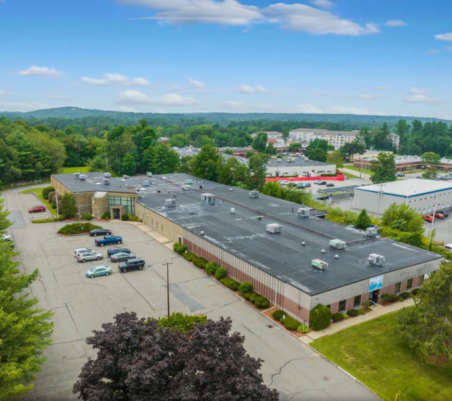
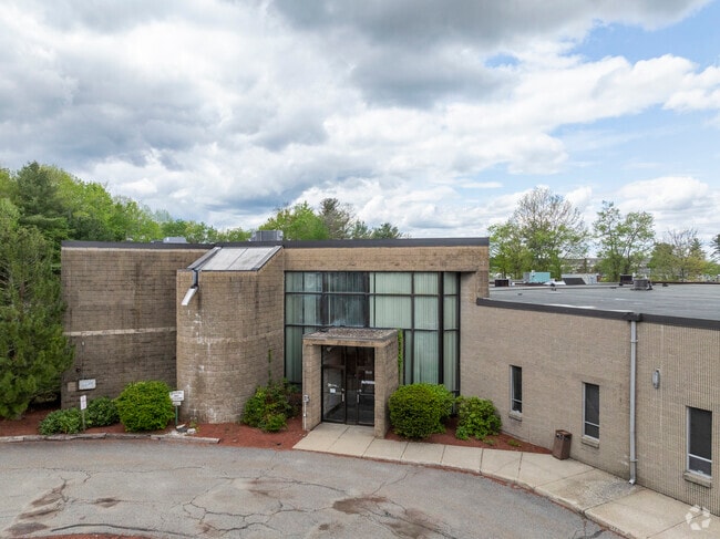
Property Record
77A Stuart Rd, Chelmsford, MA 01824

Current Lease Availabilities
Property Detail
77A Stuart Rd
CHEL-000096-000328-000003
MIDDLESEX
Manufacturinglight
Massachusetts
IA
3
B and X Area of moderate flood hazard, usually the area between the limits of the 100-year and 500-year floods.
4.88 AC
2025
Lowell/Chelmsford
2025
Boston
317101
Boston-Cambridge-Newton, MA-NH
53,922 SF
NEARBY LISTINGS FOR SALE OR LEASE
DEMOGRAPHICS near 77A Stuart Rd
1 mile
3 mile
5 mile
2025 Total Population
3,728
63,174
201,898
2030 Population
3,923
65,531
208,657
Pop Growth 2025-2030
+ 5.23%
+ 3.73%
+ 3.35%
Average Age
42
41
40
2025 Total Households
1,423
22,785
73,684
HH Growth 2025-2030
+ 5.48%
+ 3.94%
+ 3.53%
Median Household Inc
$122,754
$114,826
$101,339
Avg Household Size
2.50
2.70
2.60
2025 Avg HH Vehicles
2.00
2.00
2.00
Median Home Value
$670,986
$545,449
$552,860
Median Year Built
1967
1964
1964
Nearby Places
Map Layers
Map Styles
 Street
 Aerial
Transit
 Traffic
 Biking
Places
Listings with unknown addresses are not visible on the map
- Restaurants
- Banks
- Shops
- Fitness
- Groceries
PUBLIC TRANSPORTATION
COMMUTER RAIL
North Billerica (Lowell Line - Massachusetts Bay Transportation Authority Commuter Rail (Purple Line))
Drive
Walk
Distance
North Billerica (Lowell Line - Massachusetts Bay Transportation Authority Commuter Rail (Purple Line))
7 min
3.0 mi
Lowell (Lowell Line - Massachusetts Bay Transportation Authority Commuter Rail (Purple Line))
Drive
Walk
Distance
Lowell (Lowell Line - Massachusetts Bay Transportation Authority Commuter Rail (Purple Line))
9 min
4.7 mi
AIRPORT
General Edward Lawrence Logan International
Drive
Walk
Distance
General Edward Lawrence Logan International
45 min
29.6 mi
Manchester Boston Regional
Drive
Walk
Distance
Manchester Boston Regional
48 min
32.3 mi
Freight Ports
Port of Boston
Drive
Walk
Distance
Port of Boston
46 min
29.4 mi
Nearby Properties
Address
Land Use
TOTAL SIZE
Lot Size
Zoning
Address
Land Use
TOTAL SIZE
Lot Size
Zoning
14.73 AC
HRC
Address
Land Use
TOTAL SIZE
Lot Size
Zoning
275,574 SF
6.66 AC
HRCO
Address
Land Use
TOTAL SIZE
Lot Size
Zoning
Address
Land Use
TOTAL SIZE
Lot Size
Zoning
189,960 SF
7.88 AC
4
Address
Land Use
TOTAL SIZE
Lot Size
Zoning
11.45 AC
TTF
Address
Land Use
TOTAL SIZE
Lot Size
Zoning
15.16 AC
SMF
Address
Land Use
TOTAL SIZE
Lot Size
Zoning
174 SF
IA
Address
Land Use
TOTAL SIZE
Lot Size
Zoning
396,990 SF
48.84 AC
IH
Address
Land Use
TOTAL SIZE
Lot Size
Zoning
19.97 AC
SSF
Address
Land Use
TOTAL SIZE
Lot Size
Zoning
345,780 SF
64.77 AC
3
Address
Land Use
TOTAL SIZE
Lot Size
Zoning
380,132 SF
35.87 AC
5
Address
Land Use
TOTAL SIZE
Lot Size
Zoning
137,235 SF
12.77 AC
5
Address
Land Use
TOTAL SIZE
Lot Size
Zoning
38.26 AC
P
Address
Land Use
TOTAL SIZE
Lot Size
Zoning
26.65 AC
IA
Address
Land Use
TOTAL SIZE
Lot Size
Zoning
7.41 AC
CB
Address
Land Use
TOTAL SIZE
Lot Size
Zoning
4.85 AC
IA
Address
Land Use
TOTAL SIZE
Lot Size
Zoning
22.30 AC
IA
Address
Land Use
TOTAL SIZE
Lot Size
Zoning
3,954 SF
13.42 AC
IA
Address
Land Use
TOTAL SIZE
Lot Size
Zoning
18.50 AC
CC
Address
Land Use
TOTAL SIZE
Lot Size
Zoning
2,856 SF
11.82 AC
SMF
Address
Land Use
TOTAL SIZE
Lot Size
Zoning
6.93 AC
SMU
Address
Land Use
TOTAL SIZE
Lot Size
Zoning
355,104 SF
Address
Land Use
TOTAL SIZE
Lot Size
Zoning
241,545 SF
18.28 AC
CC
Address
Land Use
TOTAL SIZE
Lot Size
Zoning
9.48 AC
RB
Address
Land Use
TOTAL SIZE
Lot Size
Zoning
13.23 AC
Address
Land Use
TOTAL SIZE
Lot Size
Zoning
148,890 SF
6.99 AC
5
Address
Land Use
TOTAL SIZE
Lot Size
Zoning
37.14 AC
IA
Address
Land Use
TOTAL SIZE
Lot Size
Zoning
5.26 AC
SMF
Address
Land Use
TOTAL SIZE
Lot Size
Zoning
130,120 SF
9.76 AC
IA
Address
Land Use
TOTAL SIZE
Lot Size
Zoning
3.82 AC
TTF
The World's #1 Commercial Real Estate Marketplace
Connect with us
© 2026 CoStar Group
The information above has been obtained from sources believed reliable. While we do not doubt its accuracy we have not verified it and make no guarantee, warranty or representation about it. It is your responsibility to independently confirm its accuracy and completeness. Any projections, opinions, assumptions, or estimates used are for example only and do not represent the current or future performance of the property. The value of this transaction to you depends on tax and other factors which should be evaluated by your tax, financial, and legal advisors. You and your advisors should conduct a careful, independent investigation of the property to determine to your satisfaction the suitability of the property for your needs.