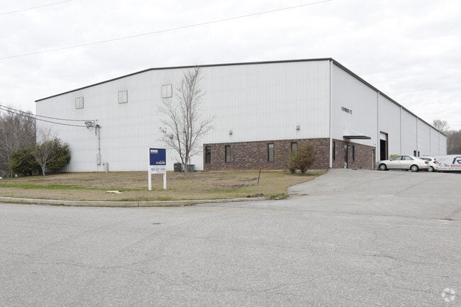
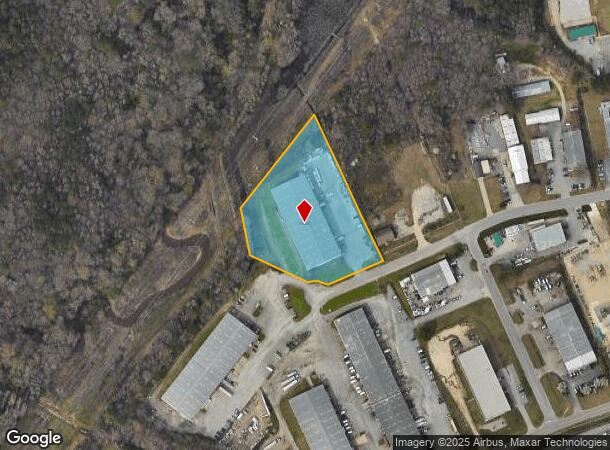
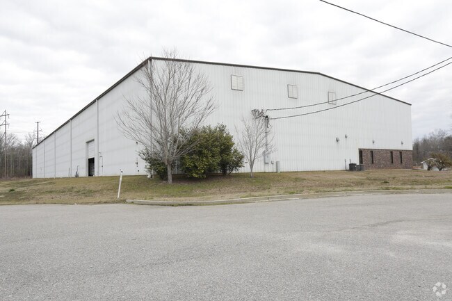
Property Record
7 Sunbelt Ct, Columbia, SC 29203
NEARBY LISTINGS FOR SALE OR LEASE
Property Detail
7 Sunbelt Ct
09409-01-23
James C Judy
Commercialnec
PARCEL 3-B 150.8X49.2X69.3X182.2X151.2X 390.8X515 #SU
AE
Richland
45079C0233L
South Carolina
2025
3.16 AC
2024
North Columbia
010701
Columbia
34,200 SF
Columbia, SC
DEMOGRAPHICS near 7 Sunbelt Ct
1 Mile
3 Mile
5 Mile
2024 Total Population
1,646
37,152
115,499
2029 Population
1,686
37,970
118,106
Pop Growth 2024-2029
+ 2.43%
+ 2.20%
+ 2.26%
Average Age
39
39
38
2024 Total Households
704
16,274
49,706
HH Growth 2024-2029
+ 2.41%
+ 2.23%
+ 2.41%
Median Household Inc
$33,548
$34,807
$40,361
Avg Household Size
2.30
2.20
2.10
2024 Avg HH Vehicles
2.00
1.00
1.00
Median Home Value
$81,216
$110,050
$153,790
Median Year Built
1965
1969
1971
Nearby Places
Map Layers
Map Styles
 Street
 Aerial
- Restaurants
- Banks
- Shops
- Fitness
- Groceries
PUBLIC TRANSPORTATION
COMMUTER RAIL
DRIVE
WALK
Distance
16 min
6.1 mi
AIRPORT
Columbia Metro
DRIVE
WALK
Distance
Columbia Metro
30 min
15.5 mi
SALE & LEASE HISTORY
LISTING DATE
SALE/LEASE

Sep 04, 2018
For Lease
Oct 16, 2018
For Lease
Feb 02, 2018
For Sale
Nearby Properties
Address
Land Use
TOTAL SIZE
Lot Size
Zoning
Address
Land Use
TOTAL SIZE
Lot Size
Zoning
20,434 SF
17.20 AC
C-1
Address
Land Use
TOTAL SIZE
Lot Size
Zoning
278,912 SF
23.24 AC
RM-HD
Address
Land Use
TOTAL SIZE
Lot Size
Zoning
207,112 SF
16.86 AC
RM-HD
Address
Land Use
TOTAL SIZE
Lot Size
Zoning
237,885 SF
20.76 AC
RM-2
Address
Land Use
TOTAL SIZE
Lot Size
Zoning
208,688 SF
13.02 AC
RM-HD
Address
Land Use
TOTAL SIZE
Lot Size
Zoning
153,272 SF
9.63 AC
RM-HD
Address
Land Use
TOTAL SIZE
Lot Size
Zoning
2,456 SF
5 AC
C-1
Address
Land Use
TOTAL SIZE
Lot Size
Zoning
96,189 SF
2.22 AC
C-1
Address
Land Use
TOTAL SIZE
Lot Size
Zoning
127,063 SF
14.70 AC
RM-HD
Address
Land Use
TOTAL SIZE
Lot Size
Zoning
34,393 SF
2.96 AC
M-1
Address
Land Use
TOTAL SIZE
Lot Size
Zoning
67,200 SF
1.72 AC
C-1
Address
Land Use
TOTAL SIZE
Lot Size
Zoning
90,430 SF
0.42 AC
C-1
Address
Land Use
TOTAL SIZE
Lot Size
Zoning
23,916 SF
4.43 AC
RG-2
Address
Land Use
TOTAL SIZE
Lot Size
Zoning
124,272 SF
7.06 AC
RM-HD
Address
Land Use
TOTAL SIZE
Lot Size
Zoning
100 SF
44.73 AC
C-1
Address
Land Use
TOTAL SIZE
Lot Size
Zoning
63,842 SF
3.52 AC
C-3
Address
Land Use
TOTAL SIZE
Lot Size
Zoning
4,986 SF
5.74 AC
PUD-C
Address
Land Use
TOTAL SIZE
Lot Size
Zoning
98,436 SF
14 AC
INS-GEN
Address
Land Use
TOTAL SIZE
Lot Size
Zoning
103,405 SF
0.38 AC
C-3
Address
Land Use
TOTAL SIZE
Lot Size
Zoning
82,692 SF
5.87 AC
C-3
Address
Land Use
TOTAL SIZE
Lot Size
Zoning
134,400 SF
5.85 AC
RG-2
Address
Land Use
TOTAL SIZE
Lot Size
Zoning
199,962 SF
40.13 AC
RG-1
Address
Land Use
TOTAL SIZE
Lot Size
Zoning
96,248 SF
5.97 AC
RM-2
Address
Land Use
TOTAL SIZE
Lot Size
Zoning
8,032 SF
3.20 AC
C-1
Address
Land Use
TOTAL SIZE
Lot Size
Zoning
32,030 SF
1.06 AC
M-1
Address
Land Use
TOTAL SIZE
Lot Size
Zoning
194,212 SF
15.10 AC
RG-2
Address
Land Use
TOTAL SIZE
Lot Size
Zoning
107,302 SF
16.77 AC
EC
Address
Land Use
TOTAL SIZE
Lot Size
Zoning
183,690 SF
16.17 AC
RG-2
Address
Land Use
TOTAL SIZE
Lot Size
Zoning
75,981 SF
1.33 AC
C-1
Address
Land Use
TOTAL SIZE
Lot Size
Zoning
42,735 SF
2.12 AC
C-1
The World's #1 Commercial Real Estate Marketplace
Connect with us
© 2026 CoStar Group
The information above has been obtained from sources believed reliable. While we do not doubt its accuracy we have not verified it and make no guarantee, warranty or representation about it. It is your responsibility to independently confirm its accuracy and completeness. Any projections, opinions, assumptions, or estimates used are for example only and do not represent the current or future performance of the property. The value of this transaction to you depends on tax and other factors which should be evaluated by your tax, financial, and legal advisors. You and your advisors should conduct a careful, independent investigation of the property to determine to your satisfaction the suitability of the property for your needs.