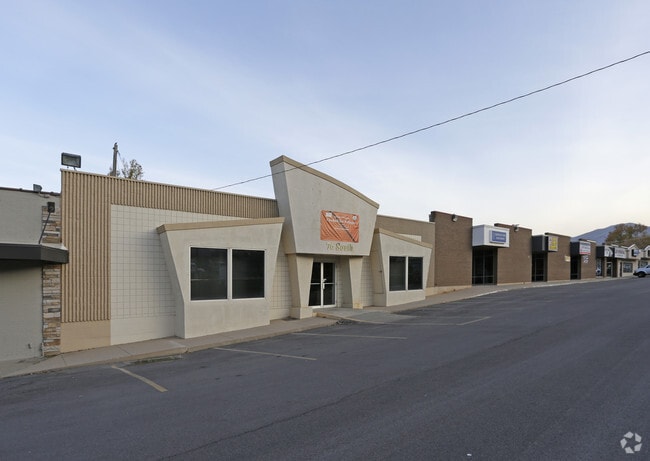
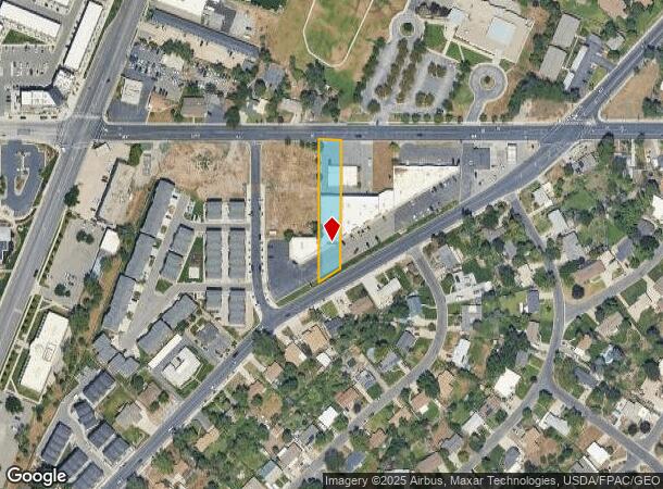
Property Record
76 S Orchard Dr, North Salt Lake, UT 84054

Current Lease Availabilities
General Retail LEASE
$8.00 - $15.00 SF/YR
2,432 - 14,288 SF
NEARBY LISTINGS FOR SALE OR LEASE
Property Detail
76 S Orchard Dr
01-108-0028
BEG AT A PT WH IS S 89^56'00" W 1942.72 FT & S 00^04'00" E 26.50 FT FR THE N 1/4 COR OF SEC 12-T1N-R1W; SLM: AS SET BY DAVIS COUNTY SURVEYOR'S OFFICE & RECORDED 11/17/72: & RUN TH S 00^04'00" E 388.15
Storebuilding
Davis
X
Utah
49035C0133G
0.50 AC
2025
Davis/Weber Counties
2025
Salt Lake City
126404
Ogden-Clearfield, UT
7,137 SF
DEMOGRAPHICS near 76 S Orchard Dr
1 Mile
3 Mile
5 Mile
2024 Total Population
12,487
54,690
140,233
2029 Population
13,245
57,708
146,135
Pop Growth 2024-2029
+ 6.07%
+ 5.52%
+ 4.21%
Average Age
35
35
36
2024 Total Households
4,274
17,804
50,120
HH Growth 2024-2029
+ 6.15%
+ 5.59%
+ 4.28%
Median Household Inc
$74,818
$90,464
$76,323
Avg Household Size
2.90
3.00
2.70
2024 Avg HH Vehicles
2.00
2.00
2.00
Median Home Value
$469,642
$446,204
$439,869
Median Year Built
1990
1990
1978
Nearby Places
Map Layers
Map Styles
 Street
 Aerial
- Restaurants
- Banks
- Shops
- Fitness
- Groceries
PUBLIC TRANSPORTATION
COMMUTER RAIL
Woods Cross (FrontRunner North - Utah Transit Authority (UTA))
DRIVE
WALK
Distance
Woods Cross (FrontRunner North - Utah Transit Authority (UTA))
8 min
3.6 mi
Warm Springs Relief Point (FrontRunner - Utah Transit Authority (UTA))
DRIVE
WALK
Distance
Warm Springs Relief Point (FrontRunner - Utah Transit Authority (UTA))
9 min
4.5 mi
AIRPORT
Salt Lake City International
DRIVE
WALK
Distance
Salt Lake City International
15 min
10.7 mi
Freight Ports
Port of Stockton
DRIVE
WALK
Distance
Port of Stockton
716 min
701.1 mi
Nearby Properties
Address
Land Use
TOTAL SIZE
Lot Size
Zoning
Address
Land Use
TOTAL SIZE
Lot Size
Zoning
1,140,230 SF
53.87 AC
B-P
Address
Land Use
TOTAL SIZE
Lot Size
Zoning
6,673 SF
345.82 AC
Address
Land Use
TOTAL SIZE
Lot Size
Zoning
463,000 SF
25.21 AC
B-P
Address
Land Use
TOTAL SIZE
Lot Size
Zoning
354,506 SF
18.44 AC
B-P
Address
Land Use
TOTAL SIZE
Lot Size
Zoning
380,631 SF
20.34 AC
BP
Address
Land Use
TOTAL SIZE
Lot Size
Zoning
341,830 SF
17.75 AC
BP
Address
Land Use
TOTAL SIZE
Lot Size
Zoning
167,620 SF
114.91 AC
M-1
Address
Land Use
TOTAL SIZE
Lot Size
Zoning
152,165 SF
8.47 AC
4144
Address
Land Use
TOTAL SIZE
Lot Size
Zoning
240,104 SF
37.03 AC
C2
Address
Land Use
TOTAL SIZE
Lot Size
Zoning
657,526 SF
35.95 AC
MD
Address
Land Use
TOTAL SIZE
Lot Size
Zoning
4,241 SF
8.67 AC
P
Address
Land Use
TOTAL SIZE
Lot Size
Zoning
208,638 SF
56.05 AC
Address
Land Use
TOTAL SIZE
Lot Size
Zoning
3,026 SF
14.42 AC
P
Address
Land Use
TOTAL SIZE
Lot Size
Zoning
138,720 SF
8.76 AC
BP
Address
Land Use
TOTAL SIZE
Lot Size
Zoning
13,126 SF
7.83 AC
P
Address
Land Use
TOTAL SIZE
Lot Size
Zoning
113,265 SF
0.55 AC
CG
Address
Land Use
TOTAL SIZE
Lot Size
Zoning
230,020 SF
27.33 AC
MD
Address
Land Use
TOTAL SIZE
Lot Size
Zoning
156,694 SF
7.67 AC
Address
Land Use
TOTAL SIZE
Lot Size
Zoning
259,942 SF
18.52 AC
MD
Address
Land Use
TOTAL SIZE
Lot Size
Zoning
155,896 SF
8.96 AC
Address
Land Use
TOTAL SIZE
Lot Size
Zoning
58,273 SF
3.80 AC
I1
Address
Land Use
TOTAL SIZE
Lot Size
Zoning
103,430 SF
6.67 AC
BP
Address
Land Use
TOTAL SIZE
Lot Size
Zoning
19,299 SF
3.06 AC
Address
Land Use
TOTAL SIZE
Lot Size
Zoning
113,197 SF
3.62 AC
Address
Land Use
TOTAL SIZE
Lot Size
Zoning
119,710 SF
13.15 AC
R4
Address
Land Use
TOTAL SIZE
Lot Size
Zoning
6,050 SF
59.94 AC
Address
Land Use
TOTAL SIZE
Lot Size
Zoning
103,724 SF
8.40 AC
M-1
Address
Land Use
TOTAL SIZE
Lot Size
Zoning
101,110 SF
8.12 AC
Address
Land Use
TOTAL SIZE
Lot Size
Zoning
57,830 SF
3.54 AC
Address
Land Use
TOTAL SIZE
Lot Size
Zoning
9,747 SF
7.73 AC
R4
The World's #1 Commercial Real Estate Marketplace
Connect with us
© 2025 CoStar Group
The information above has been obtained from sources believed reliable. While we do not doubt its accuracy we have not verified it and make no guarantee, warranty or representation about it. It is your responsibility to independently confirm its accuracy and completeness. Any projections, opinions, assumptions, or estimates used are for example only and do not represent the current or future performance of the property. The value of this transaction to you depends on tax and other factors which should be evaluated by your tax, financial, and legal advisors. You and your advisors should conduct a careful, independent investigation of the property to determine to your satisfaction the suitability of the property for your needs.