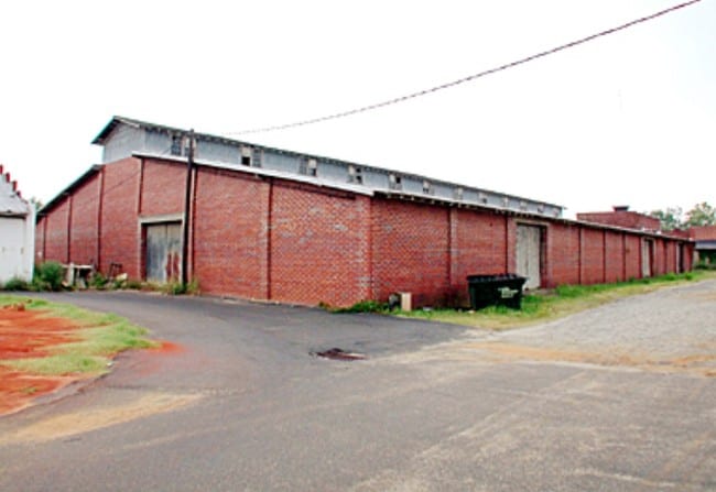
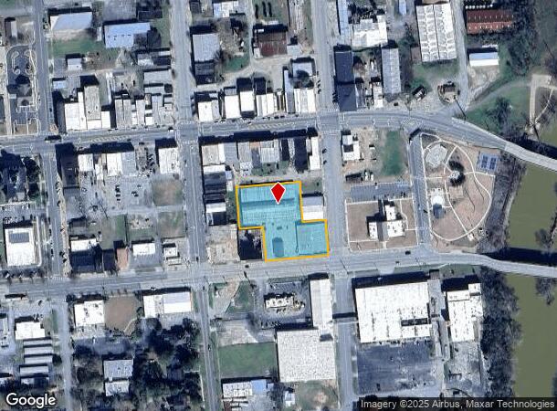
Property Record
70 Broad St, Hawkinsville, GA 31036
NEARBY LISTINGS FOR SALE OR LEASE
Property Detail
70 Broad St
H0370030021
Commercial 250
Officebuilding
1.469 AC LOT BROAD
X
Pulaski
13023C0175B
Georgia
2024
1.47 AC
2024
Georgia South Area
950201
Other Market Areas
1,533 SF
Warner Robins, GA
DEMOGRAPHICS near 70 Broad St
1 Mile
3 Mile
5 Mile
2024 Total Population
2,781
7,008
8,164
2029 Population
2,926
7,240
8,402
Pop Growth 2024-2029
+ 5.21%
+ 3.31%
+ 2.92%
Average Age
40
42
42
2024 Total Households
1,022
2,456
2,851
HH Growth 2024-2029
+ 5.68%
+ 3.46%
+ 2.98%
Median Household Inc
$33,064
$42,522
$44,944
Avg Household Size
2.30
2.40
2.40
2024 Avg HH Vehicles
1.00
2.00
2.00
Median Home Value
$89,798
$119,578
$122,059
Median Year Built
1983
1981
1980
Nearby Places
Map Layers
Map Styles
 Street
 Aerial
- Restaurants
- Banks
- Shops
- Fitness
- Groceries
Nearby Properties
Address
Land Use
TOTAL SIZE
Lot Size
Zoning
Address
Land Use
TOTAL SIZE
Lot Size
Zoning
43,763 SF
15.50 AC
004
Address
Land Use
TOTAL SIZE
Lot Size
Zoning
55,288 SF
Address
Land Use
TOTAL SIZE
Lot Size
Zoning
1.92 AC
004
Address
Land Use
TOTAL SIZE
Lot Size
Zoning
0.70 AC
002
Address
Land Use
TOTAL SIZE
Lot Size
Zoning
55,288 SF
Address
Land Use
TOTAL SIZE
Lot Size
Zoning
26,400 SF
1.74 AC
004
Address
Land Use
TOTAL SIZE
Lot Size
Zoning
12 AC
002
Address
Land Use
TOTAL SIZE
Lot Size
Zoning
0.15 AC
002
Address
Land Use
TOTAL SIZE
Lot Size
Zoning
0.20 AC
002
Address
Land Use
TOTAL SIZE
Lot Size
Zoning
19,565 SF
4 AC
001
Address
Land Use
TOTAL SIZE
Lot Size
Zoning
0.46 AC
004
Address
Land Use
TOTAL SIZE
Lot Size
Zoning
119,137 SF
99.82 AC
003
Address
Land Use
TOTAL SIZE
Lot Size
Zoning
25.54 AC
001
Address
Land Use
TOTAL SIZE
Lot Size
Zoning
44,473 SF
7.30 AC
002
Address
Land Use
TOTAL SIZE
Lot Size
Zoning
39,112 SF
3.32 AC
002
Address
Land Use
TOTAL SIZE
Lot Size
Zoning
Address
Land Use
TOTAL SIZE
Lot Size
Zoning
15,000 SF
6.16 AC
004
Address
Land Use
TOTAL SIZE
Lot Size
Zoning
9,850 SF
2.62 AC
002
Address
Land Use
TOTAL SIZE
Lot Size
Zoning
37,260 SF
3.27 AC
004
Address
Land Use
TOTAL SIZE
Lot Size
Zoning
8,246 SF
2.91 AC
002
Address
Land Use
TOTAL SIZE
Lot Size
Zoning
19,057 SF
5.11 AC
003
Address
Land Use
TOTAL SIZE
Lot Size
Zoning
27,550 SF
6.43 AC
001
Address
Land Use
TOTAL SIZE
Lot Size
Zoning
Address
Land Use
TOTAL SIZE
Lot Size
Zoning
43,473 SF
1.98 AC
001
Address
Land Use
TOTAL SIZE
Lot Size
Zoning
16,100 SF
2.63 AC
001
Address
Land Use
TOTAL SIZE
Lot Size
Zoning
9,100 SF
11.61 AC
002
Address
Land Use
TOTAL SIZE
Lot Size
Zoning
4,992 SF
1.04 AC
002
Address
Land Use
TOTAL SIZE
Lot Size
Zoning
24,000 SF
34.30 AC
004
Address
Land Use
TOTAL SIZE
Lot Size
Zoning
8,380 SF
3.89 AC
002
Address
Land Use
TOTAL SIZE
Lot Size
Zoning
13,000 SF
0.89 AC
001
The World's #1 Commercial Real Estate Marketplace
Connect with us
© 2025 CoStar Group
The information above has been obtained from sources believed reliable. While we do not doubt its accuracy we have not verified it and make no guarantee, warranty or representation about it. It is your responsibility to independently confirm its accuracy and completeness. Any projections, opinions, assumptions, or estimates used are for example only and do not represent the current or future performance of the property. The value of this transaction to you depends on tax and other factors which should be evaluated by your tax, financial, and legal advisors. You and your advisors should conduct a careful, independent investigation of the property to determine to your satisfaction the suitability of the property for your needs.