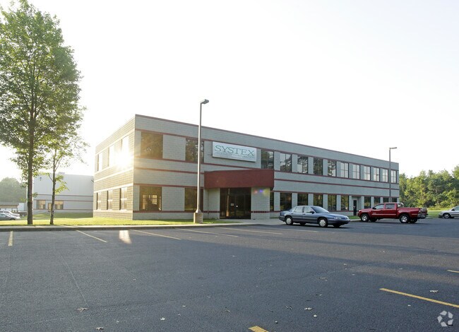
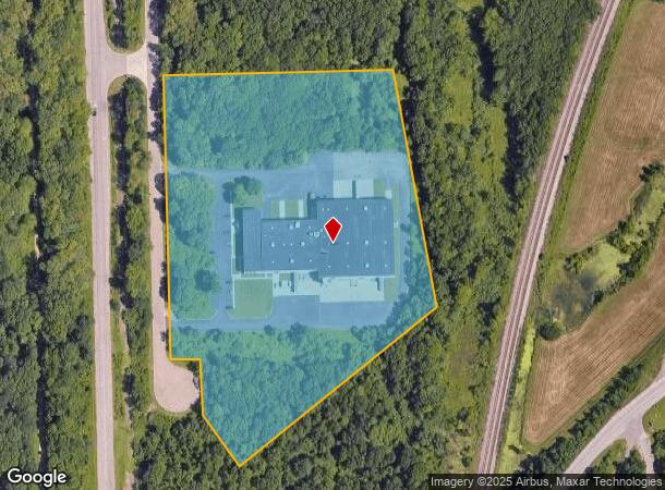
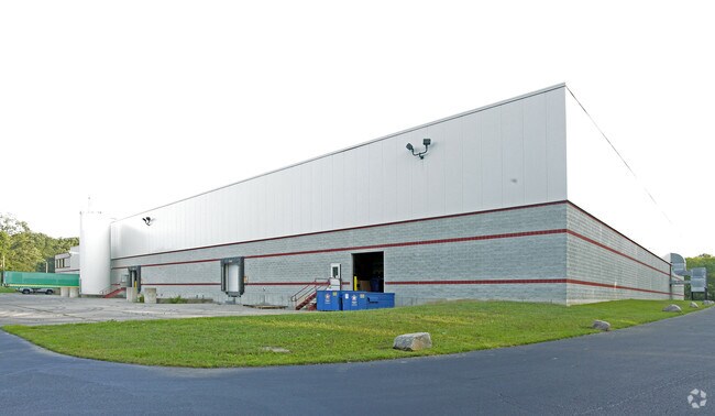
Property Record
70 Buckner Rd, Battle Creek, MI 49037
NEARBY LISTINGS FOR SALE OR LEASE
Property Detail
70 Buckner Rd
0067-00-110-0
SEC 17 T2S R8W PART OF SW 1/4 COMM SW COR OF SD SEC - N 89 DEG 57 DEG 32 MIN E ALG S LI OF SD SEC 43
Manufacturinglight
Calhoun
X
Michigan
26077C0250E
13.10 AC
0
Battle Crk/W Calhoun Cnty
2025
West Michigan
002600
Battle Creek, MI
77,948 SF
DEMOGRAPHICS near 70 Buckner Rd
1 Mile
3 Mile
5 Mile
2024 Total Population
129
10,758
44,297
2029 Population
126
10,602
43,806
Pop Growth 2024-2029
(2.33%)
(1.45%)
(1.11%)
Average Age
43
39
40
2024 Total Households
45
4,296
18,015
HH Growth 2024-2029
(2.22%)
(1.49%)
(1.14%)
Median Household Inc
$108,333
$53,516
$52,137
Avg Household Size
2.80
2.40
2.40
2024 Avg HH Vehicles
2.00
2.00
2.00
Median Home Value
$227,500
$142,780
$132,522
Median Year Built
1994
1964
1959
Nearby Places
Map Layers
Map Styles
 Street
 Aerial
- Restaurants
- Banks
- Shops
- Fitness
- Groceries
PUBLIC TRANSPORTATION
COMMUTER RAIL
Battle Creek (Blue Water - Amtrak, Wolverine - Amtrak)
DRIVE
WALK
Distance
Battle Creek (Blue Water - Amtrak, Wolverine - Amtrak)
13 min
7.0 mi
AIRPORT
Kalamazoo/Battle Creek International
DRIVE
WALK
Distance
Kalamazoo/Battle Creek International
28 min
18.2 mi
Freight Ports
Port of Toledo
DRIVE
WALK
Distance
Port of Toledo
161 min
131.0 mi
Nearby Properties
Address
Land Use
TOTAL SIZE
Lot Size
Zoning
Address
Land Use
TOTAL SIZE
Lot Size
Zoning
1,279,617 SF
86.82 AC
I2
Address
Land Use
TOTAL SIZE
Lot Size
Zoning
158,242 SF
28.01 AC
B1
Address
Land Use
TOTAL SIZE
Lot Size
Zoning
183,198 SF
17.72 AC
RM-1
Address
Land Use
TOTAL SIZE
Lot Size
Zoning
270,000 SF
24.29 AC
I2
Address
Land Use
TOTAL SIZE
Lot Size
Zoning
123,060 SF
10.53 AC
I2
Address
Land Use
TOTAL SIZE
Lot Size
Zoning
131,048 SF
12.28 AC
R1A
Address
Land Use
TOTAL SIZE
Lot Size
Zoning
415,320 SF
50.04 AC
I2
Address
Land Use
TOTAL SIZE
Lot Size
Zoning
111,002 SF
AG
Address
Land Use
TOTAL SIZE
Lot Size
Zoning
158,242 SF
25.25 AC
B1
Address
Land Use
TOTAL SIZE
Lot Size
Zoning
252,000 SF
34.57 AC
I2
Address
Land Use
TOTAL SIZE
Lot Size
Zoning
308,395 SF
24.34 AC
I2
Address
Land Use
TOTAL SIZE
Lot Size
Zoning
191,315 SF
11.29 AC
I2
Address
Land Use
TOTAL SIZE
Lot Size
Zoning
199,664 SF
24.70 AC
I2
Address
Land Use
TOTAL SIZE
Lot Size
Zoning
161,104 SF
38.28 AC
I2
Address
Land Use
TOTAL SIZE
Lot Size
Zoning
94,222 SF
I2
Address
Land Use
TOTAL SIZE
Lot Size
Zoning
188,388 SF
18.15 AC
T3
Address
Land Use
TOTAL SIZE
Lot Size
Zoning
111,744 SF
9.75 AC
RM-1
Address
Land Use
TOTAL SIZE
Lot Size
Zoning
95,666 SF
46.56 AC
I1
Address
Land Use
TOTAL SIZE
Lot Size
Zoning
123,918 SF
24.50 AC
I2
Address
Land Use
TOTAL SIZE
Lot Size
Zoning
123,544 SF
17.11 AC
I2
Address
Land Use
TOTAL SIZE
Lot Size
Zoning
157,819 SF
21.09 AC
I2
Address
Land Use
TOTAL SIZE
Lot Size
Zoning
85,800 SF
Address
Land Use
TOTAL SIZE
Lot Size
Zoning
50,000 SF
8.48 AC
R-2
Address
Land Use
TOTAL SIZE
Lot Size
Zoning
225,000 SF
21.84 AC
I2
Address
Land Use
TOTAL SIZE
Lot Size
Zoning
111,560 SF
13.80 AC
I2
Address
Land Use
TOTAL SIZE
Lot Size
Zoning
145,984 SF
10.93 AC
I2
Address
Land Use
TOTAL SIZE
Lot Size
Zoning
32,105 SF
7.51 AC
B1
Address
Land Use
TOTAL SIZE
Lot Size
Zoning
95,614 SF
5.08 AC
I2
Address
Land Use
TOTAL SIZE
Lot Size
Zoning
215,250 SF
13.39 AC
The World's #1 Commercial Real Estate Marketplace
Connect with us
© 2026 CoStar Group
The information above has been obtained from sources believed reliable. While we do not doubt its accuracy we have not verified it and make no guarantee, warranty or representation about it. It is your responsibility to independently confirm its accuracy and completeness. Any projections, opinions, assumptions, or estimates used are for example only and do not represent the current or future performance of the property. The value of this transaction to you depends on tax and other factors which should be evaluated by your tax, financial, and legal advisors. You and your advisors should conduct a careful, independent investigation of the property to determine to your satisfaction the suitability of the property for your needs.