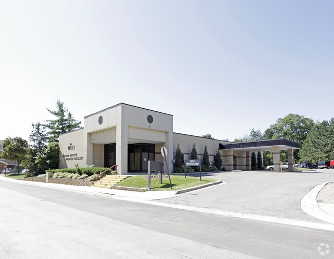
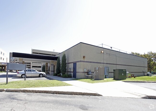
Property Record
70 Fulton St, Pontiac, MI 48341

NEARBY LISTINGS FOR SALE OR LEASE
Property Detail
70 Fulton St
Detroit-Warren-Dearborn, MI
Assessors Plat No 97
19-04-201-019
T2N, R10E, SEC 4 ASSESSORS PLAT NO 97 PART OF LOT 24 BEG AT PT DIST S 59-35-54 W 612.76 FT FROM SE COR OF NLY PART OF LOT 24 LYING N OF FULTON ST R/W, TH S 59-35-54 W 19.06 FT, TH ALG CURVE TO RIGHT, RAD 520.34 FT, CHORD BEARS S 66-51-05 W 131.39 FT,
Medicalbuilding
Oakland
X
Michigan
26125C0507F
24
2024
0.52 AC
2024
Pontiac
142700
Detroit
8,550 SF
DEMOGRAPHICS near 70 Fulton St
1 Mile
3 Mile
5 Mile
2024 Total Population
6,946
64,834
164,322
2029 Population
6,935
64,999
163,771
Pop Growth 2024-2029
(0.16%)
+ 0.25%
(0.34%)
Average Age
40
41
41
2024 Total Households
2,712
25,878
65,367
HH Growth 2024-2029
(0.37%)
+ 0.23%
(0.35%)
Median Household Inc
$38,045
$57,737
$73,214
Avg Household Size
2.50
2.40
2.40
2024 Avg HH Vehicles
2.00
2.00
2.00
Median Home Value
$139,655
$234,898
$334,910
Median Year Built
1958
1965
1967
Nearby Places
Map Layers
Map Styles
 Street
 Aerial
- Restaurants
- Banks
- Shops
- Fitness
- Groceries
PUBLIC TRANSPORTATION
COMMUTER RAIL
Pontiac Amtrak Station (Wolverine - Amtrak)
DRIVE
WALK
Distance
Pontiac Amtrak Station (Wolverine - Amtrak)
7 min
2.6 mi
Troy Amtrak Station (Wolverine - Amtrak)
DRIVE
WALK
Distance
Troy Amtrak Station (Wolverine - Amtrak)
15 min
7.5 mi
AIRPORT
Windsor International
DRIVE
WALK
Distance
Windsor International
57 min
37.9 mi
Detroit Metro Wayne County
DRIVE
WALK
Distance
Detroit Metro Wayne County
57 min
43.2 mi
Freight Ports
Port of Toledo
DRIVE
WALK
Distance
Port of Toledo
107 min
84.9 mi
Nearby Properties
Address
Land Use
TOTAL SIZE
Lot Size
Zoning
Address
Land Use
TOTAL SIZE
Lot Size
Zoning
2,734,739 SF
80.39 AC
Address
Land Use
TOTAL SIZE
Lot Size
Zoning
526,398 SF
32.99 AC
Address
Land Use
TOTAL SIZE
Lot Size
Zoning
711,360 SF
43.86 AC
Address
Land Use
TOTAL SIZE
Lot Size
Zoning
608,251 SF
50.49 AC
II
Address
Land Use
TOTAL SIZE
Lot Size
Zoning
374,400 SF
4.10 AC
Address
Land Use
TOTAL SIZE
Lot Size
Zoning
601,151 SF
Address
Land Use
TOTAL SIZE
Lot Size
Zoning
289,110 SF
6.07 AC
BI
Address
Land Use
TOTAL SIZE
Lot Size
Zoning
360,186 SF
38.44 AC
RM2
Address
Land Use
TOTAL SIZE
Lot Size
Zoning
221,340 SF
26.88 AC
Address
Land Use
TOTAL SIZE
Lot Size
Zoning
154,370 SF
8.80 AC
BI
Address
Land Use
TOTAL SIZE
Lot Size
Zoning
242,512 SF
6.60 AC
BI
Address
Land Use
TOTAL SIZE
Lot Size
Zoning
156,668 SF
13.19 AC
BI
Address
Land Use
TOTAL SIZE
Lot Size
Zoning
23.28 AC
AI
Address
Land Use
TOTAL SIZE
Lot Size
Zoning
203,643 SF
9.85 AC
IV
Address
Land Use
TOTAL SIZE
Lot Size
Zoning
199,125 SF
47.43 AC
Address
Land Use
TOTAL SIZE
Lot Size
Zoning
97,172 SF
13.82 AC
BI
Address
Land Use
TOTAL SIZE
Lot Size
Zoning
205,703 SF
21.63 AC
B2
Address
Land Use
TOTAL SIZE
Lot Size
Zoning
267,393 SF
11.11 AC
BI
Address
Land Use
TOTAL SIZE
Lot Size
Zoning
275,889 SF
12.34 AC
BI
Address
Land Use
TOTAL SIZE
Lot Size
Zoning
454,573 SF
Address
Land Use
TOTAL SIZE
Lot Size
Zoning
219,274 SF
9.75 AC
BI
Address
Land Use
TOTAL SIZE
Lot Size
Zoning
903,018 SF
73.92 AC
II
Address
Land Use
TOTAL SIZE
Lot Size
Zoning
145,712 SF
10.51 AC
BV
Address
Land Use
TOTAL SIZE
Lot Size
Zoning
158,374 SF
12.35 AC
BI
Address
Land Use
TOTAL SIZE
Lot Size
Zoning
87,560 SF
7.94 AC
BI
Address
Land Use
TOTAL SIZE
Lot Size
Zoning
288,124 SF
15.76 AC
Address
Land Use
TOTAL SIZE
Lot Size
Zoning
186,197 SF
12.11 AC
TR
Address
Land Use
TOTAL SIZE
Lot Size
Zoning
53,379 SF
139.07 AC
Address
Land Use
TOTAL SIZE
Lot Size
Zoning
152,346 SF
14.07 AC
TR
Address
Land Use
TOTAL SIZE
Lot Size
Zoning
92,524 SF
14.62 AC
TR
The World's #1 Commercial Real Estate Marketplace
Connect with us
© 2025 CoStar Group
The information above has been obtained from sources believed reliable. While we do not doubt its accuracy we have not verified it and make no guarantee, warranty or representation about it. It is your responsibility to independently confirm its accuracy and completeness. Any projections, opinions, assumptions, or estimates used are for example only and do not represent the current or future performance of the property. The value of this transaction to you depends on tax and other factors which should be evaluated by your tax, financial, and legal advisors. You and your advisors should conduct a careful, independent investigation of the property to determine to your satisfaction the suitability of the property for your needs.