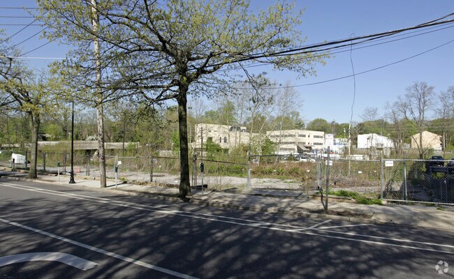
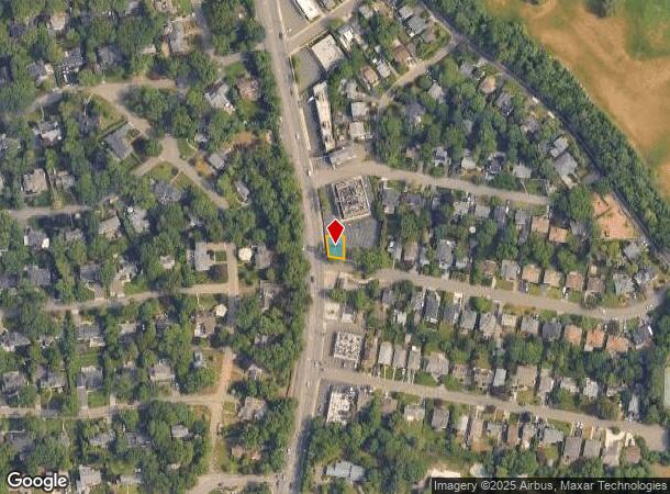
Property Record
70 Glen Cove Rd, Roslyn Heights, NY 11577
NEARBY LISTINGS FOR SALE OR LEASE
Property Detail
70 Glen Cove Rd
Nassau County-Suffolk County, NY
Map Of Red Ground Park Belonging To Will
2203-19-009-00-0232-0
TOWN #2 SCH DIST 003
Financialbuilding
Nassau
X
New York
36059C0140G
232
2025
0.06 AC
2025
Western Nassau
302102
Long Island (New York)
2,300 SF
DEMOGRAPHICS near 70 Glen Cove Rd
1 Mile
3 Mile
5 Mile
2024 Total Population
27,608
165,453
582,923
2029 Population
27,231
158,534
554,064
Pop Growth 2024-2029
(1.37%)
(4.18%)
(4.95%)
Average Age
44
45
44
2024 Total Households
10,775
61,616
202,185
HH Growth 2024-2029
(1.30%)
(4.53%)
(5.27%)
Median Household Inc
$112,941
$106,156
$97,061
Avg Household Size
2.50
2.60
2.80
2024 Avg HH Vehicles
1.00
1.00
1.00
Median Home Value
$867,508
$830,740
$775,933
Median Year Built
1953
1957
1953
Nearby Places
- Restaurants
- Banks
- Shops
- Fitness
- Groceries
PUBLIC TRANSPORTATION
COMMUTER RAIL
Greenvale Station (Oyster Bay Branch - Long Island Rail Road)
DRIVE
WALK
Distance
Greenvale Station (Oyster Bay Branch - Long Island Rail Road)
6 min
2.0 mi
Roslyn Station (Oyster Bay Branch - Long Island Rail Road)
DRIVE
WALK
Distance
Roslyn Station (Oyster Bay Branch - Long Island Rail Road)
7 min
2.1 mi
AIRPORT
LaGuardia
DRIVE
WALK
Distance
LaGuardia
18 min
17.0 mi
John F Kennedy International
DRIVE
WALK
Distance
John F Kennedy International
21 min
19.7 mi
Long Island MacArthur
DRIVE
WALK
Distance
Long Island MacArthur
32 min
30.1 mi
Nearby Properties
Address
Land Use
TOTAL SIZE
Lot Size
Zoning
Address
Land Use
TOTAL SIZE
Lot Size
Zoning
729,696 SF
579.18 AC
Address
Land Use
TOTAL SIZE
Lot Size
Zoning
600 SF
2.68 AC
Address
Land Use
TOTAL SIZE
Lot Size
Zoning
95.70 AC
Address
Land Use
TOTAL SIZE
Lot Size
Zoning
375,331 SF
14.83 AC
Address
Land Use
TOTAL SIZE
Lot Size
Zoning
352,730 SF
41.04 AC
Address
Land Use
TOTAL SIZE
Lot Size
Zoning
152,926 SF
30 AC
Address
Land Use
TOTAL SIZE
Lot Size
Zoning
83,566 SF
38.12 AC
Address
Land Use
TOTAL SIZE
Lot Size
Zoning
152,783 SF
51.20 AC
Address
Land Use
TOTAL SIZE
Lot Size
Zoning
158,725 SF
24.46 AC
Address
Land Use
TOTAL SIZE
Lot Size
Zoning
401,583 SF
17.93 AC
Address
Land Use
TOTAL SIZE
Lot Size
Zoning
50,252 SF
143.04 AC
Address
Land Use
TOTAL SIZE
Lot Size
Zoning
49,950 SF
51.02 AC
Address
Land Use
TOTAL SIZE
Lot Size
Zoning
171,770 SF
5.95 AC
Address
Land Use
TOTAL SIZE
Lot Size
Zoning
179,365 SF
6.05 AC
Address
Land Use
TOTAL SIZE
Lot Size
Zoning
197,357 SF
32.05 AC
Address
Land Use
TOTAL SIZE
Lot Size
Zoning
45,898 SF
85.13 AC
Address
Land Use
TOTAL SIZE
Lot Size
Zoning
165,793 SF
18.61 AC
Address
Land Use
TOTAL SIZE
Lot Size
Zoning
109,503 SF
12.88 AC
Address
Land Use
TOTAL SIZE
Lot Size
Zoning
140,916 SF
3.14 AC
Address
Land Use
TOTAL SIZE
Lot Size
Zoning
80,013 SF
51.03 AC
Address
Land Use
TOTAL SIZE
Lot Size
Zoning
178,455 SF
14.91 AC
Address
Land Use
TOTAL SIZE
Lot Size
Zoning
51,868 SF
44.24 AC
Address
Land Use
TOTAL SIZE
Lot Size
Zoning
171,503 SF
6.87 AC
Address
Land Use
TOTAL SIZE
Lot Size
Zoning
62,607 SF
2.63 AC
Address
Land Use
TOTAL SIZE
Lot Size
Zoning
125,184 SF
9.58 AC
Address
Land Use
TOTAL SIZE
Lot Size
Zoning
183,394 SF
18.70 AC
Address
Land Use
TOTAL SIZE
Lot Size
Zoning
30,477 SF
78.71 AC
Address
Land Use
TOTAL SIZE
Lot Size
Zoning
2,214 SF
131.50 AC
Address
Land Use
TOTAL SIZE
Lot Size
Zoning
85,980 SF
16.20 AC
Address
Land Use
TOTAL SIZE
Lot Size
Zoning
8,034 SF
15.75 AC
The World's #1 Commercial Real Estate Marketplace
Connect with us
© 2025 CoStar Group
The information above has been obtained from sources believed reliable. While we do not doubt its accuracy we have not verified it and make no guarantee, warranty or representation about it. It is your responsibility to independently confirm its accuracy and completeness. Any projections, opinions, assumptions, or estimates used are for example only and do not represent the current or future performance of the property. The value of this transaction to you depends on tax and other factors which should be evaluated by your tax, financial, and legal advisors. You and your advisors should conduct a careful, independent investigation of the property to determine to your satisfaction the suitability of the property for your needs.