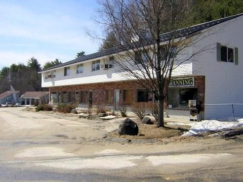
Property Record
70 Hancock Rd, Peterborough, NH 03458

Save to a Folder
{{folder.Name}}
{{folder.ListingIds.length}} Properties
{{folder.ListingIds.length}} Property
Create a New Folder
Property Detail
70 Hancock Rd
PTBR-000009U-000025
Hillsborough
Restaurantbuilding
New Hampshire
COMMER
1.45 AC
B and X Area of moderate flood hazard, usually the area between the limits of the 100-year and 500-year floods.
Hillsborough
2025
Boston
2025
Manchester-Nashua, NH
023002
NEARBY LISTINGS FOR SALE OR LEASE
-
-
View all Peterborough listings for lease on LoopNet.com
DEMOGRAPHICS near 70 Hancock Rd
1 mile
3 mile
5 mile
2025 Total Population
1,317
6,043
9,711
2030 Population
1,360
6,200
9,932
Pop Growth 2025-2030
+ 3.26%
+ 2.60%
+ 2.28%
Average Age
45
46
46
2025 Total Households
515
2,571
4,059
HH Growth 2025-2030
+ 3.50%
+ 2.61%
+ 2.34%
Median Household Inc
$103,154
$99,613
$102,176
Avg Household Size
2.50
2.30
2.30
2025 Avg HH Vehicles
2.00
2.00
2.00
Median Home Value
$399,106
$429,493
$430,615
Median Year Built
1981
1970
1972
Nearby Places
Map Layers
Map Styles
 Street
 Aerial
Layers
 Traffic
 Biking
Places
Listings with unknown addresses are not visible on the map
- Restaurants
- Banks
- Shops
- Fitness
- Groceries
PUBLIC TRANSPORTATION
AIRPORT
Manchester Boston Regional
Drive
Walk
Distance
Manchester Boston Regional
68 min
38.4 mi
Freight Ports
Port of Boston
Drive
Walk
Distance
Port of Boston
120 min
79.3 mi
SALE & LEASE HISTORY
LISTING DATE
SALE/LEASE

Jul 24, 2023
For Lease
Nearby Properties
Address
Land Use
TOTAL SIZE
Lot Size
Zoning
Address
Land Use
TOTAL SIZE
Lot Size
Zoning
30 AC
FAMILY
Address
Land Use
TOTAL SIZE
Lot Size
Zoning
88.50 AC
R
Address
Land Use
TOTAL SIZE
Lot Size
Zoning
24.24 AC
R
Address
Land Use
TOTAL SIZE
Lot Size
Zoning
369.99 AC
R
Address
Land Use
TOTAL SIZE
Lot Size
Zoning
14.09 AC
FAMILY
Address
Land Use
TOTAL SIZE
Lot Size
Zoning
10.42 AC
COMMER
Address
Land Use
TOTAL SIZE
Lot Size
Zoning
331.37 AC
FAMILY
Address
Land Use
TOTAL SIZE
Lot Size
Zoning
3.35 AC
GEN.RE
Address
Land Use
TOTAL SIZE
Lot Size
Zoning
5.21 AC
COMMER
Address
Land Use
TOTAL SIZE
Lot Size
Zoning
8.31 AC
GEN.RE
Address
Land Use
TOTAL SIZE
Lot Size
Zoning
7.50 AC
GEN.RE
Address
Land Use
TOTAL SIZE
Lot Size
Zoning
3.30 AC
GEN.RE
Address
Land Use
TOTAL SIZE
Lot Size
Zoning
Address
Land Use
TOTAL SIZE
Lot Size
Zoning
167.21 AC
FAMILY
Address
Land Use
TOTAL SIZE
Lot Size
Zoning
12.71 AC
R
Address
Land Use
TOTAL SIZE
Lot Size
Zoning
3.81 AC
COMMER
Address
Land Use
TOTAL SIZE
Lot Size
Zoning
2 AC
COMMER
Address
Land Use
TOTAL SIZE
Lot Size
Zoning
0.29 AC
COMMER
Address
Land Use
TOTAL SIZE
Lot Size
Zoning
10 AC
INDUST
Address
Land Use
TOTAL SIZE
Lot Size
Zoning
23.06 AC
INDUST
Address
Land Use
TOTAL SIZE
Lot Size
Zoning
5.71 AC
COMMER
Address
Land Use
TOTAL SIZE
Lot Size
Zoning
1.76 AC
COMMER
Address
Land Use
TOTAL SIZE
Lot Size
Zoning
1.45 AC
GEN.RE
Address
Land Use
TOTAL SIZE
Lot Size
Zoning
19.84 AC
R
Address
Land Use
TOTAL SIZE
Lot Size
Zoning
1.04 AC
COMMER
Address
Land Use
TOTAL SIZE
Lot Size
Zoning
0.79 AC
COMMER
Address
Land Use
TOTAL SIZE
Lot Size
Zoning
Address
Land Use
TOTAL SIZE
Lot Size
Zoning
14.27 AC
GEN.RE
Address
Land Use
TOTAL SIZE
Lot Size
Zoning
0.70 AC
GEN.RE
Address
Land Use
TOTAL SIZE
Lot Size
Zoning
73.43 AC
R
The World's #1 Commercial Real Estate Marketplace
Connect with us
© 2026 CoStar Group
The information above has been obtained from sources believed reliable. While we do not doubt its accuracy we have not verified it and make no guarantee, warranty or representation about it. It is your responsibility to independently confirm its accuracy and completeness. Any projections, opinions, assumptions, or estimates used are for example only and do not represent the current or future performance of the property. The value of this transaction to you depends on tax and other factors which should be evaluated by your tax, financial, and legal advisors. You and your advisors should conduct a careful, independent investigation of the property to determine to your satisfaction the suitability of the property for your needs.