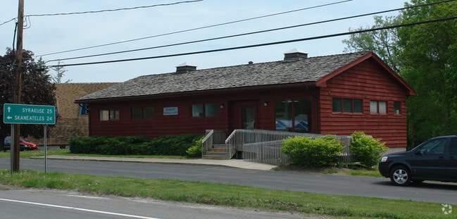
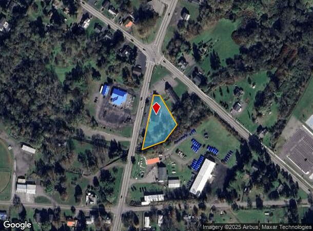
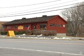
Property Record
70 N West St, Homer, NY 13077

NEARBY LISTINGS FOR SALE OR LEASE
-
-
View all Homer listings for sale on LoopNet.com
Property Detail
70 N West St
113001-066-057-0001-014-100-0000
Cortland
Officebuilding
New York
AE
14.100
36023C0139D
0.96 AC
2024
Cortland County
2024
Syracuse
970300
Cortland, NY
2,176 SF
DEMOGRAPHICS near 70 N West St
1 Mile
3 Mile
5 Mile
2024 Total Population
2,962
13,119
29,392
2029 Population
2,868
12,828
28,960
Pop Growth 2024-2029
(3.17%)
(2.22%)
(1.47%)
Average Age
43
41
39
2024 Total Households
1,271
5,435
11,378
HH Growth 2024-2029
(3.30%)
(2.43%)
(1.57%)
Median Household Inc
$68,066
$60,089
$59,297
Avg Household Size
2.30
2.20
2.20
2024 Avg HH Vehicles
2.00
2.00
2.00
Median Home Value
$146,466
$148,687
$149,087
Median Year Built
1948
1948
1953
Nearby Places
- Restaurants
- Banks
- Shops
- Fitness
- Groceries
PUBLIC TRANSPORTATION
AIRPORT
Ithaca Tompkins International
DRIVE
WALK
Distance
Ithaca Tompkins International
35 min
21.2 mi
Freight Ports
Albany, NY Port
DRIVE
WALK
Distance
Albany, NY Port
202 min
159.1 mi
Nearby Properties
Address
Land Use
TOTAL SIZE
Lot Size
Zoning
Address
Land Use
TOTAL SIZE
Lot Size
Zoning
224,991 SF
6.70 AC
05 - COMME
Address
Land Use
TOTAL SIZE
Lot Size
Zoning
18.30 AC
02 - SINGL
Address
Land Use
TOTAL SIZE
Lot Size
Zoning
157,298 SF
22.09 AC
05 - COMME
Address
Land Use
TOTAL SIZE
Lot Size
Zoning
12.80 AC
03 - MULTI
Address
Land Use
TOTAL SIZE
Lot Size
Zoning
12,402 SF
5 AC
03 - MULTI
Address
Land Use
TOTAL SIZE
Lot Size
Zoning
47,554 SF
2.30 AC
05 - COMME
Address
Land Use
TOTAL SIZE
Lot Size
Zoning
71,934 SF
4.10 AC
05 - COMME
Address
Land Use
TOTAL SIZE
Lot Size
Zoning
47,446 SF
9.30 AC
02 - SINGL
Address
Land Use
TOTAL SIZE
Lot Size
Zoning
3.80 AC
02 - SINGL
Address
Land Use
TOTAL SIZE
Lot Size
Zoning
176,040 SF
17 AC
05 - COMME
Address
Land Use
TOTAL SIZE
Lot Size
Zoning
47,228 SF
1.55 AC
05 - COMME
Address
Land Use
TOTAL SIZE
Lot Size
Zoning
48,499 SF
3 AC
05 - COMME
Address
Land Use
TOTAL SIZE
Lot Size
Zoning
37,332 SF
2 AC
05 - COMME
Address
Land Use
TOTAL SIZE
Lot Size
Zoning
3,328 SF
16.60 AC
05 - COMME
Address
Land Use
TOTAL SIZE
Lot Size
Zoning
5.02 AC
02 - SINGL
Address
Land Use
TOTAL SIZE
Lot Size
Zoning
22,357 SF
5.56 AC
03 - MULTI
Address
Land Use
TOTAL SIZE
Lot Size
Zoning
2,884 SF
1.19 AC
05 - COMME
Address
Land Use
TOTAL SIZE
Lot Size
Zoning
34,212 SF
2.23 AC
05 - COMME
Address
Land Use
TOTAL SIZE
Lot Size
Zoning
89,403 SF
4.80 AC
05 - COMME
Address
Land Use
TOTAL SIZE
Lot Size
Zoning
23,716 SF
1.22 AC
05 - COMME
Address
Land Use
TOTAL SIZE
Lot Size
Zoning
10.02 AC
04 - FARM
Address
Land Use
TOTAL SIZE
Lot Size
Zoning
2,429 SF
1.54 AC
05 - COMME
Address
Land Use
TOTAL SIZE
Lot Size
Zoning
17.80 AC
05 - COMME
Address
Land Use
TOTAL SIZE
Lot Size
Zoning
29,018 SF
1 AC
05 - COMME
Address
Land Use
TOTAL SIZE
Lot Size
Zoning
25,620 SF
4.20 AC
05 - COMME
Address
Land Use
TOTAL SIZE
Lot Size
Zoning
9,900 SF
2.23 AC
07 - MIXED
Address
Land Use
TOTAL SIZE
Lot Size
Zoning
23,486 SF
0.89 AC
05 - COMME
Address
Land Use
TOTAL SIZE
Lot Size
Zoning
18,828 SF
3.92 AC
05 - COMME
Address
Land Use
TOTAL SIZE
Lot Size
Zoning
21,161 SF
6.33 AC
51
Address
Land Use
TOTAL SIZE
Lot Size
Zoning
10,240 SF
1.16 AC
05 - COMME
The World's #1 Commercial Real Estate Marketplace
Connect with us
© 2025 CoStar Group
The information above has been obtained from sources believed reliable. While we do not doubt its accuracy we have not verified it and make no guarantee, warranty or representation about it. It is your responsibility to independently confirm its accuracy and completeness. Any projections, opinions, assumptions, or estimates used are for example only and do not represent the current or future performance of the property. The value of this transaction to you depends on tax and other factors which should be evaluated by your tax, financial, and legal advisors. You and your advisors should conduct a careful, independent investigation of the property to determine to your satisfaction the suitability of the property for your needs.