Property Record
70 Pittsfield Rd, Lenox, MA 01240
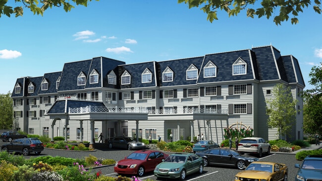

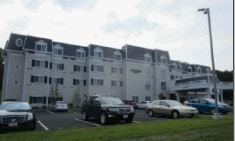
Property Detail
70 Pittsfield Rd
LENO-000017-000041-000001
BERKSHIRE
Motel
Massachusetts
C-3A
6.68 AC
2025
Massachusetts North/West Area
2025
Other Market Areas
913100
Pittsfield, MA
57,676 SF
NEARBY LISTINGS FOR SALE OR LEASE
-
-
View all Lenox listings for sale on LoopNet.com
DEMOGRAPHICS near 70 Pittsfield Rd
1 mile
3 mile
5 mile
2025 Total Population
761
6,295
23,777
2030 Population
778
6,388
23,416
Pop Growth 2025-2030
+ 2.23%
+ 1.48%
(1.52%)
Average Age
51
52
48
2025 Total Households
333
2,948
10,661
HH Growth 2025-2030
+ 2.70%
+ 1.63%
(1.42%)
Median Household Inc
$124,999
$104,908
$86,519
Avg Household Size
2.00
1.90
2.10
2025 Avg HH Vehicles
2.00
2.00
2.00
Median Home Value
$600,352
$486,666
$352,163
Median Year Built
1972
1966
1953
Nearby Places
Map Layers
Map Styles
 Street
 Aerial
Layers
 Traffic
 Biking
Places
Listings with unknown addresses are not visible on the map
- Restaurants
- Banks
- Shops
- Fitness
- Groceries
PUBLIC TRANSPORTATION
COMMUTER RAIL
Pittsfield Amtrak Station (Empire Service - Amtrak, Lake Shore Limited - Amtrak)
Drive
Walk
Distance
Pittsfield Amtrak Station (Empire Service - Amtrak, Lake Shore Limited - Amtrak)
12 min
5.5 mi
Freight Ports
Albany, NY Port
Drive
Walk
Distance
Albany, NY Port
66 min
50.5 mi
Nearby Properties
Address
Land Use
TOTAL SIZE
Lot Size
Zoning
Address
Land Use
TOTAL SIZE
Lot Size
Zoning
27,163 SF
43.27 AC
R-1A
Address
Land Use
TOTAL SIZE
Lot Size
Zoning
91.73 AC
R-1A
Address
Land Use
TOTAL SIZE
Lot Size
Zoning
60.39 AC
R-1A
Address
Land Use
TOTAL SIZE
Lot Size
Zoning
34.68 AC
C-1A
Address
Land Use
TOTAL SIZE
Lot Size
Zoning
29.60 AC
R-1A
Address
Land Use
TOTAL SIZE
Lot Size
Zoning
99.10 AC
R4
Address
Land Use
TOTAL SIZE
Lot Size
Zoning
1.95 AC
C-3A
Address
Land Use
TOTAL SIZE
Lot Size
Zoning
59,169 SF
10.10 AC
R-1A
Address
Land Use
TOTAL SIZE
Lot Size
Zoning
19,286 SF
32.70 AC
R-1A
Address
Land Use
TOTAL SIZE
Lot Size
Zoning
17.26 AC
BG
Address
Land Use
TOTAL SIZE
Lot Size
Zoning
86 AC
R4
Address
Land Use
TOTAL SIZE
Lot Size
Zoning
30,003 SF
56 AC
R-1A
Address
Land Use
TOTAL SIZE
Lot Size
Zoning
587.20 AC
R-3A
Address
Land Use
TOTAL SIZE
Lot Size
Zoning
41 AC
R4
Address
Land Use
TOTAL SIZE
Lot Size
Zoning
12.16 AC
R-1A
Address
Land Use
TOTAL SIZE
Lot Size
Zoning
1.90 AC
COMMER
Address
Land Use
TOTAL SIZE
Lot Size
Zoning
469 AC
R-3A
Address
Land Use
TOTAL SIZE
Lot Size
Zoning
79,785 SF
2.29 AC
BG
Address
Land Use
TOTAL SIZE
Lot Size
Zoning
44,912 SF
6.55 AC
C-1A
Address
Land Use
TOTAL SIZE
Lot Size
Zoning
12.76 AC
R-1A
Address
Land Use
TOTAL SIZE
Lot Size
Zoning
64,836 SF
11.05 AC
C-3A
Address
Land Use
TOTAL SIZE
Lot Size
Zoning
142,802 SF
13.74 AC
IL
Address
Land Use
TOTAL SIZE
Lot Size
Zoning
12.96 AC
BG
Address
Land Use
TOTAL SIZE
Lot Size
Zoning
340.40 AC
R-3A
Address
Land Use
TOTAL SIZE
Lot Size
Zoning
27,569 SF
10.40 AC
C-3A
Address
Land Use
TOTAL SIZE
Lot Size
Zoning
38,500 SF
4.80 AC
R-15
Address
Land Use
TOTAL SIZE
Lot Size
Zoning
7.79 AC
R-30
Address
Land Use
TOTAL SIZE
Lot Size
Zoning
18.74 AC
R-1A
Address
Land Use
TOTAL SIZE
Lot Size
Zoning
7.60 AC
R-1A
The World's #1 Commercial Real Estate Marketplace
Connect with us
© 2026 CoStar Group
The information above has been obtained from sources believed reliable. While we do not doubt its accuracy we have not verified it and make no guarantee, warranty or representation about it. It is your responsibility to independently confirm its accuracy and completeness. Any projections, opinions, assumptions, or estimates used are for example only and do not represent the current or future performance of the property. The value of this transaction to you depends on tax and other factors which should be evaluated by your tax, financial, and legal advisors. You and your advisors should conduct a careful, independent investigation of the property to determine to your satisfaction the suitability of the property for your needs.