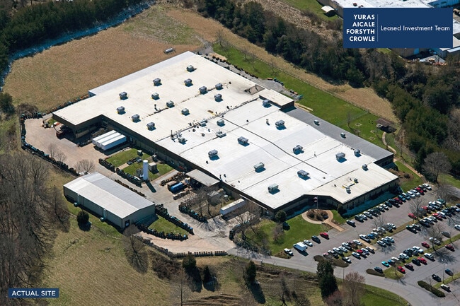
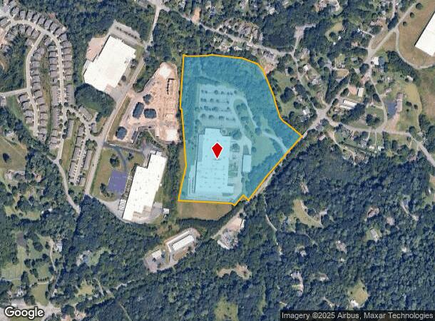
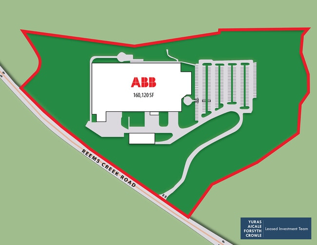
Property Record
70 Reems Creek Rd, Weaverville, NC 28787
NEARBY LISTINGS FOR SALE OR LEASE
Property Detail
70 Reems Creek Rd
Asheville, NC
Containing 23
9742-03-9274-00000
LOT: 2 PLAT: 0179-0105
Industrialgeneral
Buncombe
AE
North Carolina
3700974200J
2
2024
23.84 AC
2025
Buncombe County
002701
Asheville
166,387 SF
DEMOGRAPHICS near 70 Reems Creek Rd
1 Mile
3 Mile
5 Mile
2024 Total Population
3,146
19,785
44,508
2029 Population
3,273
20,693
46,294
Pop Growth 2024-2029
+ 4.04%
+ 4.59%
+ 4.01%
Average Age
47
47
45
2024 Total Households
1,429
8,528
18,814
HH Growth 2024-2029
+ 3.57%
+ 4.16%
+ 3.51%
Median Household Inc
$79,693
$79,095
$78,000
Avg Household Size
2.10
2.20
2.20
2024 Avg HH Vehicles
2.00
2.00
2.00
Median Home Value
$352,743
$405,199
$402,231
Median Year Built
1987
1994
1985
Nearby Places
- Restaurants
- Banks
- Shops
- Fitness
- Groceries
PUBLIC TRANSPORTATION
AIRPORT
Asheville Regional
DRIVE
WALK
Distance
Asheville Regional
31 min
21.7 mi
Freight Ports
North Charleston Terminal
DRIVE
WALK
Distance
North Charleston Terminal
302 min
265.4 mi
SALE & LEASE HISTORY
LISTING DATE
SALE/LEASE

Sep 01, 2020
For Sale
Nearby Properties
Address
Land Use
TOTAL SIZE
Lot Size
Zoning
Address
Land Use
TOTAL SIZE
Lot Size
Zoning
103,525 SF
18.23 AC
SHOPPING
Address
Land Use
TOTAL SIZE
Lot Size
Zoning
101,676 SF
19.40 AC
EMP
Address
Land Use
TOTAL SIZE
Lot Size
Zoning
153,383 SF
10.78 AC
SHOPPING
Address
Land Use
TOTAL SIZE
Lot Size
Zoning
70,312 SF
16.85 AC
I-1
Address
Land Use
TOTAL SIZE
Lot Size
Zoning
75,122 SF
16.91 AC
SHOPPING
Address
Land Use
TOTAL SIZE
Lot Size
Zoning
108,948 SF
24.68 AC
R-3
Address
Land Use
TOTAL SIZE
Lot Size
Zoning
64,521 SF
14.16 AC
R-3
Address
Land Use
TOTAL SIZE
Lot Size
Zoning
68,691 SF
131.92 AC
HEAVY
Address
Land Use
TOTAL SIZE
Lot Size
Zoning
52,470 SF
10.50 AC
I-1
Address
Land Use
TOTAL SIZE
Lot Size
Zoning
134,304 SF
16.10 AC
C-2
Address
Land Use
TOTAL SIZE
Lot Size
Zoning
61,043 SF
6.89 AC
SHOPPING
Address
Land Use
TOTAL SIZE
Lot Size
Zoning
51,555 SF
8.34 AC
R-1
Address
Land Use
TOTAL SIZE
Lot Size
Zoning
187,648 SF
18.85 AC
I-1
Address
Land Use
TOTAL SIZE
Lot Size
Zoning
414,493 SF
34.02 AC
I-1
Address
Land Use
TOTAL SIZE
Lot Size
Zoning
139,265 SF
14.97 AC
I-1
Address
Land Use
TOTAL SIZE
Lot Size
Zoning
98,003 SF
11.96 AC
C-2
Address
Land Use
TOTAL SIZE
Lot Size
Zoning
28,247 SF
3.22 AC
C-2
Address
Land Use
TOTAL SIZE
Lot Size
Zoning
47,374 SF
6.84 AC
C-2
Address
Land Use
TOTAL SIZE
Lot Size
Zoning
14,380 SF
2.14 AC
SHOPPING
Address
Land Use
TOTAL SIZE
Lot Size
Zoning
91,988 SF
28.95 AC
R-3
Address
Land Use
TOTAL SIZE
Lot Size
Zoning
35,776 SF
13.26 AC
R-1
Address
Land Use
TOTAL SIZE
Lot Size
Zoning
7.54 AC
R-1
Address
Land Use
TOTAL SIZE
Lot Size
Zoning
38,346 SF
4.96 AC
R-1
Address
Land Use
TOTAL SIZE
Lot Size
Zoning
27,832 SF
7.96 AC
SHOPPING
Address
Land Use
TOTAL SIZE
Lot Size
Zoning
20,816 SF
3.48 AC
R-1
Address
Land Use
TOTAL SIZE
Lot Size
Zoning
35,844 SF
1.58 AC
SHOPPING
Address
Land Use
TOTAL SIZE
Lot Size
Zoning
33,369 SF
10.02 AC
R-10
Address
Land Use
TOTAL SIZE
Lot Size
Zoning
37,419 SF
4.15 AC
C-2
Address
Land Use
TOTAL SIZE
Lot Size
Zoning
265,885 SF
33.47 AC
I-1
The World's #1 Commercial Real Estate Marketplace
Connect with us
© 2025 CoStar Group
The information above has been obtained from sources believed reliable. While we do not doubt its accuracy we have not verified it and make no guarantee, warranty or representation about it. It is your responsibility to independently confirm its accuracy and completeness. Any projections, opinions, assumptions, or estimates used are for example only and do not represent the current or future performance of the property. The value of this transaction to you depends on tax and other factors which should be evaluated by your tax, financial, and legal advisors. You and your advisors should conduct a careful, independent investigation of the property to determine to your satisfaction the suitability of the property for your needs.