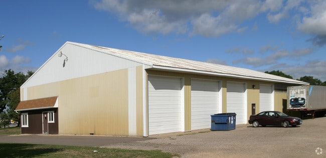
Property Record
700 77Th St, Circle Pines, MN 55014
NEARBY LISTINGS FOR SALE OR LEASE
Property Detail
700 77Th St
Minneapolis-St. Paul-Bloomington, MN-WI
Auditors Subdivision No 134
08-31-22-43-0014
AUDITORS SUB NO 134 TH PT OF THE SE1/4 OF THE SE1/4 OF SEC 8-31-22 AND TH PT OF LOT 15 OF AUDITOR'S SUB NO 134 ANOKA CNTY, MN DESC JOINTLY AS FOLLOWS -COMAT THE NE CORNER OF THE S1/2 OF SE1/4 OF S EC 8-TH W ALONG THE N LINE OF THE S1/2 OF SE1/4 A DI
Multifamilydwelling
Anoka
X
Minnesota
27003C0365E
15
2025
0.56 AC
2025
North Central
050233
Minneapolis/St Paul
1,568 SF
DEMOGRAPHICS near 700 77Th St
1 Mile
3 Mile
5 Mile
2024 Total Population
3,073
18,411
64,942
2029 Population
3,173
19,231
67,791
Pop Growth 2024-2029
+ 3.25%
+ 4.45%
+ 4.39%
Average Age
40
39
39
2024 Total Households
1,069
6,019
22,630
HH Growth 2024-2029
+ 3.46%
+ 4.47%
+ 4.33%
Median Household Inc
$110,195
$103,290
$112,744
Avg Household Size
2.80
2.90
2.80
2024 Avg HH Vehicles
2.00
2.00
2.00
Median Home Value
$321,154
$346,624
$371,232
Median Year Built
1991
1990
1996
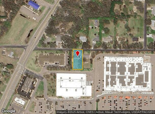
Nearby Places
Map Layers
Map Styles
 Street
 Aerial
- Restaurants
- Banks
- Shops
- Fitness
- Groceries
PUBLIC TRANSPORTATION
AIRPORT
Minneapolis-St Paul International/Wold-Chamberlain
DRIVE
WALK
Distance
Minneapolis-St Paul International/Wold-Chamberlain
40 min
27.7 mi
Freight Ports
Port Milwaukee
DRIVE
WALK
Distance
Port Milwaukee
386 min
349.9 mi
Nearby Properties
Address
Land Use
TOTAL SIZE
Lot Size
Zoning
Address
Land Use
TOTAL SIZE
Lot Size
Zoning
156,499 SF
81.20 AC
Address
Land Use
TOTAL SIZE
Lot Size
Zoning
152,721 SF
Address
Land Use
TOTAL SIZE
Lot Size
Zoning
265,400 SF
13.53 AC
Address
Land Use
TOTAL SIZE
Lot Size
Zoning
74,366 SF
10 AC
Address
Land Use
TOTAL SIZE
Lot Size
Zoning
223,763 SF
24.89 AC
Address
Land Use
TOTAL SIZE
Lot Size
Zoning
48,260 SF
10.38 AC
Address
Land Use
TOTAL SIZE
Lot Size
Zoning
43,132 SF
37.89 AC
Address
Land Use
TOTAL SIZE
Lot Size
Zoning
180,712 SF
15.95 AC
Address
Land Use
TOTAL SIZE
Lot Size
Zoning
243,028 SF
24.35 AC
Address
Land Use
TOTAL SIZE
Lot Size
Zoning
32,314 SF
4.37 AC
Address
Land Use
TOTAL SIZE
Lot Size
Zoning
Address
Land Use
TOTAL SIZE
Lot Size
Zoning
109,470 SF
12.67 AC
Address
Land Use
TOTAL SIZE
Lot Size
Zoning
6,316 SF
28.25 AC
Address
Land Use
TOTAL SIZE
Lot Size
Zoning
79,827 SF
2.81 AC
Address
Land Use
TOTAL SIZE
Lot Size
Zoning
120,680 SF
11.46 AC
Address
Land Use
TOTAL SIZE
Lot Size
Zoning
67,688 SF
40 AC
Address
Land Use
TOTAL SIZE
Lot Size
Zoning
881 SF
8.96 AC
Address
Land Use
TOTAL SIZE
Lot Size
Zoning
83,351 SF
Address
Land Use
TOTAL SIZE
Lot Size
Zoning
51,042 SF
8.73 AC
Address
Land Use
TOTAL SIZE
Lot Size
Zoning
140,684 SF
3.65 AC
Address
Land Use
TOTAL SIZE
Lot Size
Zoning
1,144 SF
39 AC
Address
Land Use
TOTAL SIZE
Lot Size
Zoning
3,947 SF
40 AC
Address
Land Use
TOTAL SIZE
Lot Size
Zoning
83,252 SF
7.75 AC
Address
Land Use
TOTAL SIZE
Lot Size
Zoning
2,265 SF
17.81 AC
Address
Land Use
TOTAL SIZE
Lot Size
Zoning
95,852 SF
10.10 AC
Address
Land Use
TOTAL SIZE
Lot Size
Zoning
71,284 SF
2.07 AC
Address
Land Use
TOTAL SIZE
Lot Size
Zoning
78,587 SF
20 AC
Address
Land Use
TOTAL SIZE
Lot Size
Zoning
3,000 SF
5.75 AC
Address
Land Use
TOTAL SIZE
Lot Size
Zoning
140,684 SF
10.88 AC
Address
Land Use
TOTAL SIZE
Lot Size
Zoning
32,420 SF
9.80 AC
The World's #1 Commercial Real Estate Marketplace
Connect with us
© 2026 CoStar Group
The information above has been obtained from sources believed reliable. While we do not doubt its accuracy we have not verified it and make no guarantee, warranty or representation about it. It is your responsibility to independently confirm its accuracy and completeness. Any projections, opinions, assumptions, or estimates used are for example only and do not represent the current or future performance of the property. The value of this transaction to you depends on tax and other factors which should be evaluated by your tax, financial, and legal advisors. You and your advisors should conduct a careful, independent investigation of the property to determine to your satisfaction the suitability of the property for your needs.