Property Record
700 E Bayton St, Alliance, OH 44601


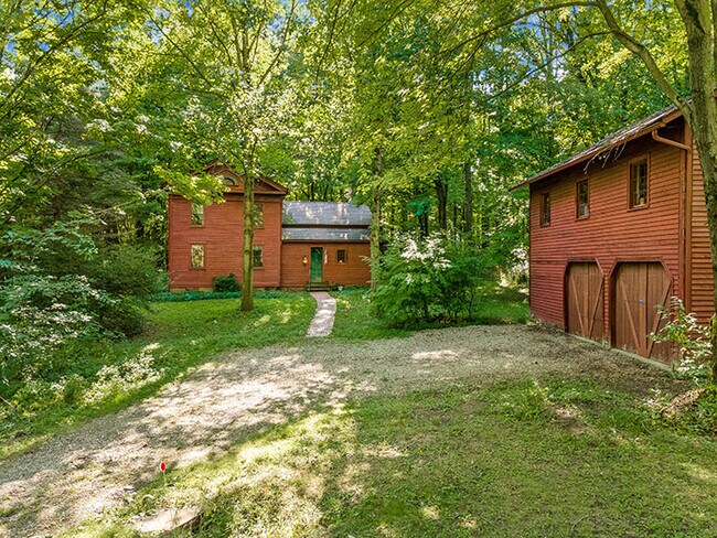
Property Detail
700 E Bayton St
07505578
12SW 6.71A; 12SE 4.07A (FORESTRY MNGMT PLAN)
Timberlandforesttreesagricultural
Stark
B and X Area of moderate flood hazard, usually the area between the limits of the 100-year and 500-year floods.
Ohio
0
10.78 AC
2025
Stark County
712800
Cleveland
2,392 SF
Canton-Massillon, OH
NEARBY LISTINGS FOR SALE OR LEASE
DEMOGRAPHICS near 700 E Bayton St
1 mile
3 mile
5 mile
2025 Total Population
746
20,315
35,893
2030 Population
729
20,280
35,934
Pop Growth 2025-2030
(2.28%)
(0.17%)
+ 0.11%
Average Age
45
41
42
2025 Total Households
314
8,148
14,591
HH Growth 2025-2030
(2.23%)
(0.15%)
+ 0.21%
Median Household Inc
$85,759
$63,268
$60,601
Avg Household Size
2.40
2.30
2.30
2025 Avg HH Vehicles
2.00
2.00
2.00
Median Home Value
$176,587
$146,014
$145,981
Median Year Built
1956
1952
1954
Nearby Places
Map Layers
Map Styles
 Street
 Aerial
Transit
 Traffic
 Biking
Places
Listings with unknown addresses are not visible on the map
- Restaurants
- Banks
- Shops
- Fitness
- Groceries
SALE & LEASE HISTORY
LISTING DATE
SALE/LEASE

Sep 15, 2020
For Sale
Nearby Properties
Address
Land Use
TOTAL SIZE
Lot Size
Zoning
Address
Land Use
TOTAL SIZE
Lot Size
Zoning
1,015,253 SF
83.25 AC
Address
Land Use
TOTAL SIZE
Lot Size
Zoning
294,532 SF
7.73 AC
Address
Land Use
TOTAL SIZE
Lot Size
Zoning
121,669 SF
27.80 AC
Address
Land Use
TOTAL SIZE
Lot Size
Zoning
275,422 SF
10 AC
Address
Land Use
TOTAL SIZE
Lot Size
Zoning
402,113 SF
25.10 AC
Address
Land Use
TOTAL SIZE
Lot Size
Zoning
79,700 SF
1.80 AC
Address
Land Use
TOTAL SIZE
Lot Size
Zoning
120,552 SF
10.37 AC
Address
Land Use
TOTAL SIZE
Lot Size
Zoning
69,467 SF
18.25 AC
Address
Land Use
TOTAL SIZE
Lot Size
Zoning
75,318 SF
4.59 AC
Address
Land Use
TOTAL SIZE
Lot Size
Zoning
56,112 SF
6.37 AC
Address
Land Use
TOTAL SIZE
Lot Size
Zoning
134,368 SF
10.30 AC
Address
Land Use
TOTAL SIZE
Lot Size
Zoning
73,764 SF
1.52 AC
Address
Land Use
TOTAL SIZE
Lot Size
Zoning
29,455 SF
8 AC
Address
Land Use
TOTAL SIZE
Lot Size
Zoning
130,339 SF
10.28 AC
Address
Land Use
TOTAL SIZE
Lot Size
Zoning
53,959 SF
3.58 AC
Address
Land Use
TOTAL SIZE
Lot Size
Zoning
49,226 SF
10.57 AC
Address
Land Use
TOTAL SIZE
Lot Size
Zoning
52,644 SF
1.03 AC
Address
Land Use
TOTAL SIZE
Lot Size
Zoning
34,078 SF
28.41 AC
Address
Land Use
TOTAL SIZE
Lot Size
Zoning
80,552 SF
68.27 AC
Address
Land Use
TOTAL SIZE
Lot Size
Zoning
29,283 SF
1.53 AC
Address
Land Use
TOTAL SIZE
Lot Size
Zoning
154,537 SF
14.37 AC
Address
Land Use
TOTAL SIZE
Lot Size
Zoning
34,504 SF
2.37 AC
Address
Land Use
TOTAL SIZE
Lot Size
Zoning
51,803 SF
1.89 AC
Address
Land Use
TOTAL SIZE
Lot Size
Zoning
26.28 AC
Address
Land Use
TOTAL SIZE
Lot Size
Zoning
24,624 SF
3.99 AC
Address
Land Use
TOTAL SIZE
Lot Size
Zoning
3,240 SF
5.43 AC
Address
Land Use
TOTAL SIZE
Lot Size
Zoning
10,480 SF
1.06 AC
Address
Land Use
TOTAL SIZE
Lot Size
Zoning
51,236 SF
10 AC
Address
Land Use
TOTAL SIZE
Lot Size
Zoning
14,132 SF
13.79 AC
Address
Land Use
TOTAL SIZE
Lot Size
Zoning
37,883 SF
7.25 AC
The World's #1 Commercial Real Estate Marketplace
Connect with us
© 2026 CoStar Group
The information above has been obtained from sources believed reliable. While we do not doubt its accuracy we have not verified it and make no guarantee, warranty or representation about it. It is your responsibility to independently confirm its accuracy and completeness. Any projections, opinions, assumptions, or estimates used are for example only and do not represent the current or future performance of the property. The value of this transaction to you depends on tax and other factors which should be evaluated by your tax, financial, and legal advisors. You and your advisors should conduct a careful, independent investigation of the property to determine to your satisfaction the suitability of the property for your needs.