Property Record
700 E Magnolia Ave, Manitowoc, WI 54220

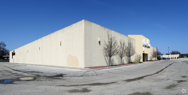

Property Detail
700 E Magnolia Ave
Manitowoc, WI
HARBOR VIEW LOTS 6-22 INCL OF BLOCK 6 & 7 & SOUTH 10 OF LOT 1 & 2 & SOUTH 10 OF EAST 28 OF LOT 3 & LOTS 6-22 INCL BLOCK 8 PART LOT 31 OEHLER & GUENTHERS SUBD NORTH OF MAGNOLIA WEST OF HOLLY & ALL VAC STREETS ABUTTING
052-330-008-152.00
Manitowoc
Taxexempt
Wisconsin
B and X Area of moderate flood hazard, usually the area between the limits of the 100-year and 500-year floods.
6-22
0
12.12 AC
2025
Wisconsin South Area
000100
Other Market Areas
181,616 SF
NEARBY LISTINGS FOR SALE OR LEASE
DEMOGRAPHICS near 700 E Magnolia Ave
1 mile
3 mile
5 mile
2025 Total Population
3,322
22,108
48,256
2030 Population
3,365
22,081
48,208
Pop Growth 2025-2030
+ 1.29%
(0.12%)
(0.10%)
Average Age
45
42
44
2025 Total Households
1,743
9,789
21,392
HH Growth 2025-2030
+ 1.03%
(0.12%)
(0.10%)
Median Household Inc
$49,051
$59,480
$61,209
Avg Household Size
1.80
2.20
2.20
2025 Avg HH Vehicles
2.00
2.00
2.00
Median Home Value
$192,274
$164,678
$170,667
Median Year Built
1978
1952
1959
Nearby Places
Map Layers
Map Styles
 Street
 Aerial
Layers
 Traffic
 Biking
Places
Listings with unknown addresses are not visible on the map
- Restaurants
- Banks
- Shops
- Fitness
- Groceries
Nearby Properties
Address
Land Use
TOTAL SIZE
Lot Size
Zoning
Address
Land Use
TOTAL SIZE
Lot Size
Zoning
97,963 SF
12.33 AC
B3
Address
Land Use
TOTAL SIZE
Lot Size
Zoning
105,564 SF
13.27 AC
Address
Land Use
TOTAL SIZE
Lot Size
Zoning
45,901 SF
9.26 AC
Address
Land Use
TOTAL SIZE
Lot Size
Zoning
15,775 SF
1.64 AC
Address
Land Use
TOTAL SIZE
Lot Size
Zoning
677,161 SF
9.15 AC
Address
Land Use
TOTAL SIZE
Lot Size
Zoning
79,008 SF
11.47 AC
Address
Land Use
TOTAL SIZE
Lot Size
Zoning
7.08 AC
Address
Land Use
TOTAL SIZE
Lot Size
Zoning
48,828 SF
0.65 AC
Address
Land Use
TOTAL SIZE
Lot Size
Zoning
12,845 SF
11 AC
Address
Land Use
TOTAL SIZE
Lot Size
Zoning
64,206 SF
3.76 AC
Address
Land Use
TOTAL SIZE
Lot Size
Zoning
82,148 SF
5.34 AC
Address
Land Use
TOTAL SIZE
Lot Size
Zoning
11.60 AC
Address
Land Use
TOTAL SIZE
Lot Size
Zoning
71.56 AC
Address
Land Use
TOTAL SIZE
Lot Size
Zoning
37.85 AC
Address
Land Use
TOTAL SIZE
Lot Size
Zoning
69,436 SF
18 AC
Address
Land Use
TOTAL SIZE
Lot Size
Zoning
157,392 SF
7.54 AC
PUD
Address
Land Use
TOTAL SIZE
Lot Size
Zoning
30.22 AC
I2
Address
Land Use
TOTAL SIZE
Lot Size
Zoning
5.62 AC
Address
Land Use
TOTAL SIZE
Lot Size
Zoning
30,576 SF
11.25 AC
Address
Land Use
TOTAL SIZE
Lot Size
Zoning
6.46 AC
Address
Land Use
TOTAL SIZE
Lot Size
Zoning
6.07 AC
Address
Land Use
TOTAL SIZE
Lot Size
Zoning
61,440 SF
4.95 AC
Address
Land Use
TOTAL SIZE
Lot Size
Zoning
45,097 SF
3.58 AC
Address
Land Use
TOTAL SIZE
Lot Size
Zoning
49,525 SF
0.40 AC
Address
Land Use
TOTAL SIZE
Lot Size
Zoning
638,600 SF
20.47 AC
I2
Address
Land Use
TOTAL SIZE
Lot Size
Zoning
84,696 SF
11.69 AC
Address
Land Use
TOTAL SIZE
Lot Size
Zoning
29,034 SF
2.63 AC
Address
Land Use
TOTAL SIZE
Lot Size
Zoning
19.05 AC
Address
Land Use
TOTAL SIZE
Lot Size
Zoning
35,189 SF
0.88 AC
Address
Land Use
TOTAL SIZE
Lot Size
Zoning
24,492 SF
2.21 AC
The World's #1 Commercial Real Estate Marketplace
Connect with us
© 2026 CoStar Group
The information above has been obtained from sources believed reliable. While we do not doubt its accuracy we have not verified it and make no guarantee, warranty or representation about it. It is your responsibility to independently confirm its accuracy and completeness. Any projections, opinions, assumptions, or estimates used are for example only and do not represent the current or future performance of the property. The value of this transaction to you depends on tax and other factors which should be evaluated by your tax, financial, and legal advisors. You and your advisors should conduct a careful, independent investigation of the property to determine to your satisfaction the suitability of the property for your needs.