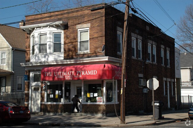
Property Record
700 W 4Th St, Plainfield, NJ 07060
NEARBY LISTINGS FOR SALE OR LEASE
Property Detail
700 W 4Th St
Newark, NJ
Spooner Estate
12-00114-0000-00018
ADDITIONAL LOTS: 2832 SQ FT
Commercialnec
Union
X
New Jersey
34023C0031F
18
2024
0.13 AC
2025
Route 22 East
039400
Northern New Jersey
2,832 SF
DEMOGRAPHICS near 700 W 4Th St
1 Mile
3 Mile
5 Mile
2024 Total Population
29,739
135,065
270,191
2029 Population
29,022
133,455
267,993
Pop Growth 2024-2029
(2.41%)
(1.19%)
(0.81%)
Average Age
35
39
40
2024 Total Households
8,352
43,554
88,596
HH Growth 2024-2029
(2.49%)
(1.17%)
(0.84%)
Median Household Inc
$57,152
$87,917
$114,683
Avg Household Size
3.30
3.00
2.90
2024 Avg HH Vehicles
2.00
2.00
2.00
Median Home Value
$332,741
$376,432
$464,064
Median Year Built
1948
1957
1964
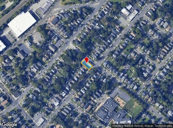
Nearby Places
Map Layers
Map Styles
 Street
 Aerial
- Restaurants
- Banks
- Shops
- Fitness
- Groceries
PUBLIC TRANSPORTATION
TRANSIT/SUBWAY
Plainfield (Raritan Valley Line - NJ Transit Commuter Rail (NJ Transit))
DRIVE
WALK
Distance
Plainfield (Raritan Valley Line - NJ Transit Commuter Rail (NJ Transit))
4 min
19 min
1.0 mi
COMMUTER RAIL
Plainfield (Raritan Valley Line - NJ Transit Commuter Rail (NJ Transit))
DRIVE
WALK
Distance
Plainfield (Raritan Valley Line - NJ Transit Commuter Rail (NJ Transit))
3 min
19 min
1.0 mi
Netherwood (Raritan Valley Line - NJ Transit Commuter Rail (NJ Transit))
DRIVE
WALK
Distance
Netherwood (Raritan Valley Line - NJ Transit Commuter Rail (NJ Transit))
6 min
2.2 mi
AIRPORT
Newark Liberty International
DRIVE
WALK
Distance
Newark Liberty International
33 min
22.4 mi
Trenton Mercer
DRIVE
WALK
Distance
Trenton Mercer
62 min
38.7 mi
LaGuardia
DRIVE
WALK
Distance
LaGuardia
69 min
41.6 mi
Freight Ports
New York Container Terminal
DRIVE
WALK
Distance
New York Container Terminal
36 min
18.1 mi
SALE & LEASE HISTORY
LISTING DATE
SALE/LEASE

Jul 21, 2020
For Sale
Nearby Properties
Address
Land Use
TOTAL SIZE
Lot Size
Zoning
Address
Land Use
TOTAL SIZE
Lot Size
Zoning
17.01 AC
RM
Address
Land Use
TOTAL SIZE
Lot Size
Zoning
20.08 AC
RML1
Address
Land Use
TOTAL SIZE
Lot Size
Zoning
17.64 AC
R10A
Address
Land Use
TOTAL SIZE
Lot Size
Zoning
12.57 AC
RM
Address
Land Use
TOTAL SIZE
Lot Size
Zoning
26.87 AC
H-D
Address
Land Use
TOTAL SIZE
Lot Size
Zoning
10.09 AC
Address
Land Use
TOTAL SIZE
Lot Size
Zoning
27.70 AC
Address
Land Use
TOTAL SIZE
Lot Size
Zoning
16.21 AC
RM
Address
Land Use
TOTAL SIZE
Lot Size
Zoning
233,217 SF
36.91 AC
LI5
Address
Land Use
TOTAL SIZE
Lot Size
Zoning
15.79 AC
H-D
Address
Land Use
TOTAL SIZE
Lot Size
Zoning
12.47 AC
H-D
Address
Land Use
TOTAL SIZE
Lot Size
Zoning
7.91 AC
RM
Address
Land Use
TOTAL SIZE
Lot Size
Zoning
9.38 AC
RM
Address
Land Use
TOTAL SIZE
Lot Size
Zoning
19.84 AC
Address
Land Use
TOTAL SIZE
Lot Size
Zoning
9.85 AC
10A
Address
Land Use
TOTAL SIZE
Lot Size
Zoning
16.97 AC
Address
Land Use
TOTAL SIZE
Lot Size
Zoning
30.80 AC
R10
Address
Land Use
TOTAL SIZE
Lot Size
Zoning
4.74 AC
NC
Address
Land Use
TOTAL SIZE
Lot Size
Zoning
19.84 AC
H-D
Address
Land Use
TOTAL SIZE
Lot Size
Zoning
30.40 AC
PR
Address
Land Use
TOTAL SIZE
Lot Size
Zoning
19.19 AC
R-3
Address
Land Use
TOTAL SIZE
Lot Size
Zoning
10,328 SF
7.53 AC
R4
Address
Land Use
TOTAL SIZE
Lot Size
Zoning
21.53 AC
H-D
Address
Land Use
TOTAL SIZE
Lot Size
Zoning
80,262 SF
11.47 AC
ER
Address
Land Use
TOTAL SIZE
Lot Size
Zoning
122,820 SF
14.65 AC
H-D
Address
Land Use
TOTAL SIZE
Lot Size
Zoning
12.52 AC
H-D
Address
Land Use
TOTAL SIZE
Lot Size
Zoning
23.45 AC
RHC
Address
Land Use
TOTAL SIZE
Lot Size
Zoning
21.60 AC
M3
Address
Land Use
TOTAL SIZE
Lot Size
Zoning
11.20 AC
Address
Land Use
TOTAL SIZE
Lot Size
Zoning
0.39 AC
R5
The World's #1 Commercial Real Estate Marketplace
Connect with us
© 2026 CoStar Group
The information above has been obtained from sources believed reliable. While we do not doubt its accuracy we have not verified it and make no guarantee, warranty or representation about it. It is your responsibility to independently confirm its accuracy and completeness. Any projections, opinions, assumptions, or estimates used are for example only and do not represent the current or future performance of the property. The value of this transaction to you depends on tax and other factors which should be evaluated by your tax, financial, and legal advisors. You and your advisors should conduct a careful, independent investigation of the property to determine to your satisfaction the suitability of the property for your needs.