Property Record
700 Gadsden Hwy, Birmingham, AL 35235


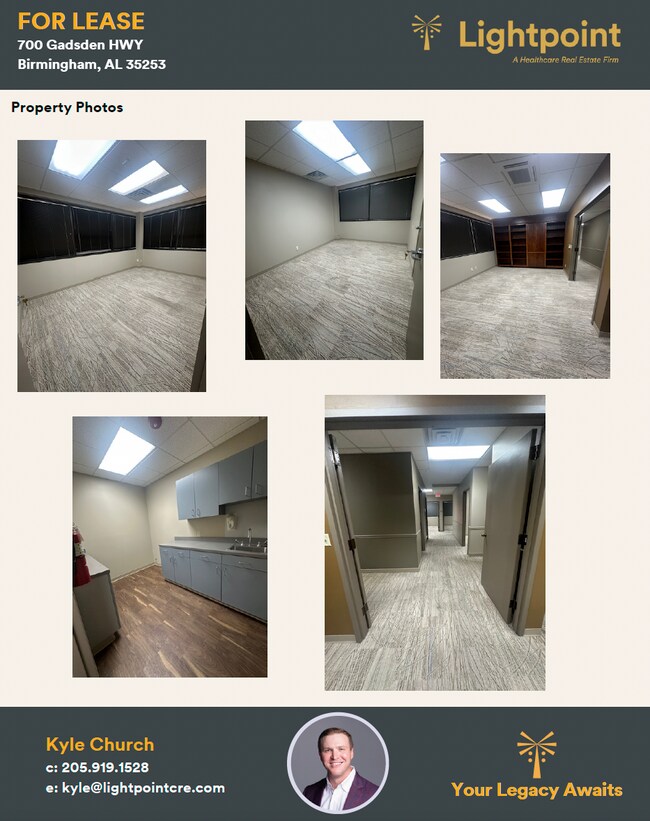
Current Lease Availabilities
NEARBY LISTINGS FOR SALE OR LEASE
Property Detail
700 Gadsden Hwy
24-00-06-1-001-029.000
COM NE COR SE 1/4 NE 1/4 TH S 186 S TO POB CONT S 152 S TH SW 118 S TO NE R/W US HWY #11 TH NW ON NE R/W 290 S TH N 126 S TH NELY & SELY ALONG CURVE 327 S TO POB SECT 06 TWSP 17S RANGE 1W
Medicalbuilding
Jefferson
X
Alabama
01073C0408H
1.45 AC
2024
Trussville
2024
Birmingham
011113
Birmingham, AL
13,758 SF
DEMOGRAPHICS near 700 Gadsden Hwy
1 Mile
3 Mile
5 Mile
2024 Total Population
4,297
34,234
98,142
2029 Population
4,183
33,698
96,674
Pop Growth 2024-2029
(2.65%)
(1.57%)
(1.50%)
Average Age
40
38
38
2024 Total Households
1,706
13,239
37,995
HH Growth 2024-2029
(2.75%)
(1.64%)
(1.57%)
Median Household Inc
$58,640
$49,460
$49,318
Avg Household Size
2.30
2.50
2.50
2024 Avg HH Vehicles
2.00
2.00
2.00
Median Home Value
$152,101
$141,542
$153,440
Median Year Built
1964
1970
1973
Nearby Places
Map Layers
Map Styles
 Street
 Aerial
- Restaurants
- Banks
- Shops
- Fitness
- Groceries
PUBLIC TRANSPORTATION
AIRPORT
Birmingham-Shuttlesworth International
DRIVE
WALK
Distance
Birmingham-Shuttlesworth International
18 min
8.5 mi
Nearby Properties
Address
Land Use
TOTAL SIZE
Lot Size
Zoning
Address
Land Use
TOTAL SIZE
Lot Size
Zoning
152,664 SF
12.44 AC
CO&I
Address
Land Use
TOTAL SIZE
Lot Size
Zoning
326,294 SF
25.99 AC
R4&U
Address
Land Use
TOTAL SIZE
Lot Size
Zoning
128,233 SF
CO&I
Address
Land Use
TOTAL SIZE
Lot Size
Zoning
155,845 SF
17 AC
C2
Address
Land Use
TOTAL SIZE
Lot Size
Zoning
137,168 SF
63 AC
A1
Address
Land Use
TOTAL SIZE
Lot Size
Zoning
150,160 SF
12 AC
INST
Address
Land Use
TOTAL SIZE
Lot Size
Zoning
168,744 SF
8.46 AC
I1
Address
Land Use
TOTAL SIZE
Lot Size
Zoning
1 SF
7.08 AC
CB2
Address
Land Use
TOTAL SIZE
Lot Size
Zoning
94,262 SF
17.30 AC
C-2
Address
Land Use
TOTAL SIZE
Lot Size
Zoning
58,509 SF
CO&I
Address
Land Use
TOTAL SIZE
Lot Size
Zoning
207,383 SF
17 AC
CR5
Address
Land Use
TOTAL SIZE
Lot Size
Zoning
39,890 SF
7.10 AC
R8
Address
Land Use
TOTAL SIZE
Lot Size
Zoning
57,296 SF
CO&I
Address
Land Use
TOTAL SIZE
Lot Size
Zoning
112,806 SF
2.04 AC
R2
Address
Land Use
TOTAL SIZE
Lot Size
Zoning
166,144 SF
12.95 AC
CB2
Address
Land Use
TOTAL SIZE
Lot Size
Zoning
178,988 SF
8.29 AC
CR5
Address
Land Use
TOTAL SIZE
Lot Size
Zoning
205,872 SF
12.53 AC
CB2
Address
Land Use
TOTAL SIZE
Lot Size
Zoning
194,730 SF
25 AC
I-1
Address
Land Use
TOTAL SIZE
Lot Size
Zoning
113,014 SF
8 AC
I1
Address
Land Use
TOTAL SIZE
Lot Size
Zoning
115,490 SF
3.88 AC
R2
Address
Land Use
TOTAL SIZE
Lot Size
Zoning
149,773 SF
7.30 AC
CR5
Address
Land Use
TOTAL SIZE
Lot Size
Zoning
176,232 SF
5.20 AC
C2
Address
Land Use
TOTAL SIZE
Lot Size
Zoning
110,776 SF
11.10 AC
C2
Address
Land Use
TOTAL SIZE
Lot Size
Zoning
95,172 SF
6.40 AC
R2
Address
Land Use
TOTAL SIZE
Lot Size
Zoning
53,864 SF
6.58 AC
C2
Address
Land Use
TOTAL SIZE
Lot Size
Zoning
71,028 SF
9.90 AC
O-I
Address
Land Use
TOTAL SIZE
Lot Size
Zoning
49,858 SF
7.30 AC
C4
Address
Land Use
TOTAL SIZE
Lot Size
Zoning
97,652 SF
6.20 AC
C2
Address
Land Use
TOTAL SIZE
Lot Size
Zoning
170,992 SF
10 AC
C1
Address
Land Use
TOTAL SIZE
Lot Size
Zoning
122,397 SF
13.13 AC
C1
The World's #1 Commercial Real Estate Marketplace
Connect with us
© 2026 CoStar Group
The information above has been obtained from sources believed reliable. While we do not doubt its accuracy we have not verified it and make no guarantee, warranty or representation about it. It is your responsibility to independently confirm its accuracy and completeness. Any projections, opinions, assumptions, or estimates used are for example only and do not represent the current or future performance of the property. The value of this transaction to you depends on tax and other factors which should be evaluated by your tax, financial, and legal advisors. You and your advisors should conduct a careful, independent investigation of the property to determine to your satisfaction the suitability of the property for your needs.