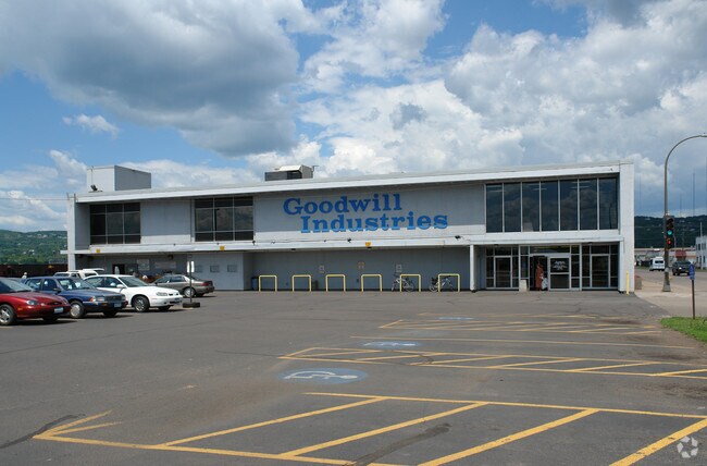
Property Record
700 Garfield Ave, Duluth, MN 55802

NEARBY LISTINGS FOR SALE OR LEASE
Property Detail
700 Garfield Ave
Duluth, MN-WI
Rices Point Duluth
010391001230
LOTS 81 THRU 119 ODD NOS INC VAC ALLEYAND AVE ADJ SERIAL #
Charitableorganization
St Louis
X
Minnesota
27137C3788E
81-119
0
1.57 AC
2024
Lincoln Park/Garfield
015600
Duluth
121,050 SF
DEMOGRAPHICS near 700 Garfield Ave
1 Mile
3 Mile
5 Mile
2024 Total Population
1,030
32,813
81,676
2029 Population
1,022
32,460
80,562
Pop Growth 2024-2029
(0.78%)
(1.08%)
(1.36%)
Average Age
37
39
39
2024 Total Households
566
15,908
35,398
HH Growth 2024-2029
(0.88%)
(1.06%)
(1.42%)
Median Household Inc
$27,310
$43,375
$51,656
Avg Household Size
1.70
1.90
2.10
2024 Avg HH Vehicles
1.00
1.00
2.00
Median Home Value
$133,544
$162,059
$183,886
Median Year Built
1948
1948
1952
Nearby Places
Map Layers
Map Styles
 Street
 Aerial
- Restaurants
- Banks
- Shops
- Fitness
- Groceries
PUBLIC TRANSPORTATION
AIRPORT
Duluth International
DRIVE
WALK
Distance
Duluth International
22 min
9.9 mi
Freight Ports
Port Milwaukee
DRIVE
WALK
Distance
Port Milwaukee
449 min
396.4 mi
SALE & LEASE HISTORY
LISTING DATE
SALE/LEASE

May 27, 2025
For Sale
Nearby Properties
Address
Land Use
TOTAL SIZE
Lot Size
Zoning
Address
Land Use
TOTAL SIZE
Lot Size
Zoning
539,170 SF
0.49 AC
Address
Land Use
TOTAL SIZE
Lot Size
Zoning
338,800 SF
0.17 AC
Address
Land Use
TOTAL SIZE
Lot Size
Zoning
547,975 SF
18.72 AC
Address
Land Use
TOTAL SIZE
Lot Size
Zoning
328,704 SF
3.81 AC
Address
Land Use
TOTAL SIZE
Lot Size
Zoning
391,335 SF
53.53 AC
Address
Land Use
TOTAL SIZE
Lot Size
Zoning
372,356 SF
1.35 AC
Address
Land Use
TOTAL SIZE
Lot Size
Zoning
175 AC
W1
Address
Land Use
TOTAL SIZE
Lot Size
Zoning
134,100 SF
0.17 AC
Address
Land Use
TOTAL SIZE
Lot Size
Zoning
195,455 SF
54.06 AC
Address
Land Use
TOTAL SIZE
Lot Size
Zoning
248,716 SF
1.02 AC
Address
Land Use
TOTAL SIZE
Lot Size
Zoning
40,835 SF
0.33 AC
Address
Land Use
TOTAL SIZE
Lot Size
Zoning
203,540 SF
0.24 AC
Address
Land Use
TOTAL SIZE
Lot Size
Zoning
93,584 SF
0.66 AC
Address
Land Use
TOTAL SIZE
Lot Size
Zoning
97,552 SF
1.29 AC
Address
Land Use
TOTAL SIZE
Lot Size
Zoning
232,586 SF
0.16 AC
Address
Land Use
TOTAL SIZE
Lot Size
Zoning
2.81 AC
PDD
Address
Land Use
TOTAL SIZE
Lot Size
Zoning
178,184 SF
20 AC
Address
Land Use
TOTAL SIZE
Lot Size
Zoning
205,584 SF
0.81 AC
Address
Land Use
TOTAL SIZE
Lot Size
Zoning
178,104 SF
0.95 AC
Address
Land Use
TOTAL SIZE
Lot Size
Zoning
113,615 SF
0.32 AC
R4
Address
Land Use
TOTAL SIZE
Lot Size
Zoning
107,796 SF
9.19 AC
Address
Land Use
TOTAL SIZE
Lot Size
Zoning
175,168 SF
0.16 AC
Address
Land Use
TOTAL SIZE
Lot Size
Zoning
62,634 SF
4.32 AC
Address
Land Use
TOTAL SIZE
Lot Size
Zoning
144,760 SF
0.56 AC
C4
Address
Land Use
TOTAL SIZE
Lot Size
Zoning
68,296 SF
0.38 AC
Address
Land Use
TOTAL SIZE
Lot Size
Zoning
97,157 SF
1.61 AC
Address
Land Use
TOTAL SIZE
Lot Size
Zoning
144,408 SF
1.29 AC
Address
Land Use
TOTAL SIZE
Lot Size
Zoning
372,356 SF
1.15 AC
Address
Land Use
TOTAL SIZE
Lot Size
Zoning
72,980 SF
2.85 AC
R1B
The World's #1 Commercial Real Estate Marketplace
Connect with us
© 2026 CoStar Group
The information above has been obtained from sources believed reliable. While we do not doubt its accuracy we have not verified it and make no guarantee, warranty or representation about it. It is your responsibility to independently confirm its accuracy and completeness. Any projections, opinions, assumptions, or estimates used are for example only and do not represent the current or future performance of the property. The value of this transaction to you depends on tax and other factors which should be evaluated by your tax, financial, and legal advisors. You and your advisors should conduct a careful, independent investigation of the property to determine to your satisfaction the suitability of the property for your needs.