Property Record
700 Jackson St, Hillsdale, IL 61257


NEARBY LISTINGS FOR SALE OR LEASE
-
-
View all Hillsdale listings for sale on LoopNet.com
Property Detail
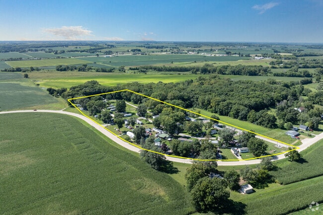
700 Jackson St
Davenport/Moline/Rock Island
Plat Of Survey Beverly Hills Estates
Davenport-Moline-Rock Island, IA-IL
PART OF SW 1/4 OF SE 1/4 OF SE 1/4 OF SECTION 29. SHEET 21
06-29-400-033
Rock Island
Commercialnec
Illinois
2024
6.70 AC
2024
Eastern Outlying Rock Island County
020101
DEMOGRAPHICS near 700 Jackson St
1 Mile
3 Mile
5 Mile
2024 Total Population
426
721
1,421
2029 Population
420
701
1,364
Pop Growth 2024-2029
(1.41%)
(2.77%)
(4.01%)
Average Age
44
44
44
2024 Total Households
185
308
579
HH Growth 2024-2029
(1.08%)
(2.60%)
(3.80%)
Median Household Inc
$65,357
$72,856
$81,610
Avg Household Size
2.30
2.30
2.40
2024 Avg HH Vehicles
2.00
2.00
2.00
Median Home Value
$60,546
$77,678
$136,937
Median Year Built
1962
1963
1967
Nearby Places
Map Layers
Map Styles
 Street
 Aerial
- Restaurants
- Banks
- Shops
- Fitness
- Groceries
PUBLIC TRANSPORTATION
AIRPORT
Quad Cities International
DRIVE
WALK
Distance
Quad Cities International
40 min
25.9 mi
Freight Ports
Port Milwaukee
DRIVE
WALK
Distance
Port Milwaukee
213 min
186.7 mi
SALE & LEASE HISTORY
LISTING DATE
SALE/LEASE

May 30, 2019
For Sale
Aug 15, 2024
For Sale
Nearby Properties
Address
Land Use
TOTAL SIZE
Lot Size
Zoning
Address
Land Use
TOTAL SIZE
Lot Size
Zoning
10.16 AC
Address
Land Use
TOTAL SIZE
Lot Size
Zoning
13,344 SF
2 AC
B2
Address
Land Use
TOTAL SIZE
Lot Size
Zoning
Address
Land Use
TOTAL SIZE
Lot Size
Zoning
5 AC
B2
Address
Land Use
TOTAL SIZE
Lot Size
Zoning
6,142 SF
1.22 AC
AG1
Address
Land Use
TOTAL SIZE
Lot Size
Zoning
80 AC
AG1
Address
Land Use
TOTAL SIZE
Lot Size
Zoning
9,849 SF
108.08 AC
AG1
Address
Land Use
TOTAL SIZE
Lot Size
Zoning
3.80 AC
Address
Land Use
TOTAL SIZE
Lot Size
Zoning
16 AC
Address
Land Use
TOTAL SIZE
Lot Size
Zoning
160.06 AC
Address
Land Use
TOTAL SIZE
Lot Size
Zoning
4,119 SF
0.29 AC
B2
Address
Land Use
TOTAL SIZE
Lot Size
Zoning
4,800 SF
5.46 AC
I1
Address
Land Use
TOTAL SIZE
Lot Size
Zoning
9,996 SF
5.18 AC
B2
Address
Land Use
TOTAL SIZE
Lot Size
Zoning
160.02 AC
Address
Land Use
TOTAL SIZE
Lot Size
Zoning
0.23 AC
AG1
Address
Land Use
TOTAL SIZE
Lot Size
Zoning
80 AC
Address
Land Use
TOTAL SIZE
Lot Size
Zoning
79 AC
Address
Land Use
TOTAL SIZE
Lot Size
Zoning
79.99 AC
Address
Land Use
TOTAL SIZE
Lot Size
Zoning
2,016 SF
2.97 AC
B4
Address
Land Use
TOTAL SIZE
Lot Size
Zoning
1,588 SF
101.60 AC
AG1
Address
Land Use
TOTAL SIZE
Lot Size
Zoning
12,480 SF
1.88 AC
B4
Address
Land Use
TOTAL SIZE
Lot Size
Zoning
2,756 SF
57.59 AC
AG1
Address
Land Use
TOTAL SIZE
Lot Size
Zoning
Address
Land Use
TOTAL SIZE
Lot Size
Zoning
80.01 AC
Address
Land Use
TOTAL SIZE
Lot Size
Zoning
123.64 AC
Address
Land Use
TOTAL SIZE
Lot Size
Zoning
60 AC
Address
Land Use
TOTAL SIZE
Lot Size
Zoning
1,840 SF
10.39 AC
Address
Land Use
TOTAL SIZE
Lot Size
Zoning
Address
Land Use
TOTAL SIZE
Lot Size
Zoning
19.68 AC
Address
Land Use
TOTAL SIZE
Lot Size
Zoning
5,108 SF
0.18 AC
R1
The World's #1 Commercial Real Estate Marketplace
Connect with us
© 2025 CoStar Group
The information above has been obtained from sources believed reliable. While we do not doubt its accuracy we have not verified it and make no guarantee, warranty or representation about it. It is your responsibility to independently confirm its accuracy and completeness. Any projections, opinions, assumptions, or estimates used are for example only and do not represent the current or future performance of the property. The value of this transaction to you depends on tax and other factors which should be evaluated by your tax, financial, and legal advisors. You and your advisors should conduct a careful, independent investigation of the property to determine to your satisfaction the suitability of the property for your needs.