Property Record
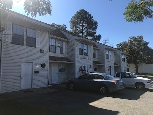
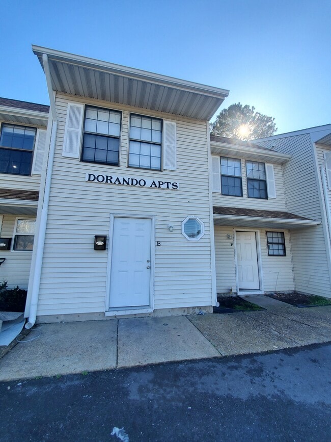
700 Kecoughtan Rd, Hampton, VA 23661

Property Detail
700 Kecoughtan Rd
1004679
NEWPT NWS CO.L18.19.20.PT17.PC2.PC3. B27
Highriseapartments
Hampton City
13 C-1 NEI
Virginia
B and X Area of moderate flood hazard, usually the area between the limits of the 100-year and 500-year floods.
18-20
2025
0.30 AC
2025
Wythe
011500
Hampton Roads
5,112 SF
Virginia Beach-Chesapeake-Norfolk, VA-NC
NEARBY LISTINGS FOR SALE OR LEASE
DEMOGRAPHICS near 700 Kecoughtan Rd
1 mile
3 mile
5 mile
2025 Total Population
10,441
62,787
131,206
2030 Population
10,599
62,896
130,883
Pop Growth 2025-2030
+ 1.51%
+ 0.17%
(0.25%)
Average Age
40
39
39
2025 Total Households
4,238
26,224
54,955
HH Growth 2025-2030
+ 1.44%
+ 0.08%
(0.24%)
Median Household Inc
$49,230
$49,509
$59,548
Avg Household Size
2.40
2.30
2.20
2025 Avg HH Vehicles
2.00
2.00
2.00
Median Home Value
$181,053
$202,951
$223,115
Median Year Built
1954
1964
1969
Nearby Places
Map Layers
Map Styles
 Street
 Aerial
Transit
 Traffic
 Biking
Places
Listings with unknown addresses are not visible on the map
- Restaurants
- Banks
- Shops
- Fitness
- Groceries
PUBLIC TRANSPORTATION
AIRPORT
Newport News/Williamsburg International
Drive
Walk
Distance
Newport News/Williamsburg International
23 min
14.9 mi
Norfolk International
Drive
Walk
Distance
Norfolk International
32 min
20.9 mi
SALE & LEASE HISTORY
LISTING DATE
SALE/LEASE

May 09, 2024
For Sale
Feb 05, 2024
For Sale
Nearby Properties
Address
Land Use
TOTAL SIZE
Lot Size
Zoning
Address
Land Use
TOTAL SIZE
Lot Size
Zoning
1 SF
444.26 AC
M2
Address
Land Use
TOTAL SIZE
Lot Size
Zoning
2,993 SF
169.83 AC
M2
Address
Land Use
TOTAL SIZE
Lot Size
Zoning
110,881 SF
2.30 AC
C3
Address
Land Use
TOTAL SIZE
Lot Size
Zoning
199,364 SF
22.12 AC
6 R-11 ONE
Address
Land Use
TOTAL SIZE
Lot Size
Zoning
135,333 SF
8.22 AC
C3
Address
Land Use
TOTAL SIZE
Lot Size
Zoning
116,905 SF
7.42 AC
C3
Address
Land Use
TOTAL SIZE
Lot Size
Zoning
540,444 SF
33.66 AC
32 M-2 LIG
Address
Land Use
TOTAL SIZE
Lot Size
Zoning
230,974 SF
42.68 AC
5 R-13 ONE
Address
Land Use
TOTAL SIZE
Lot Size
Zoning
88,941 SF
29.32 AC
11 MD-4 MU
Address
Land Use
TOTAL SIZE
Lot Size
Zoning
100 SF
35.50 AC
R7
Address
Land Use
TOTAL SIZE
Lot Size
Zoning
260,228 SF
37.04 AC
M1
Address
Land Use
TOTAL SIZE
Lot Size
Zoning
17,368 SF
7.08 AC
11 MD-4 MU
Address
Land Use
TOTAL SIZE
Lot Size
Zoning
100 SF
26.21 AC
R7
Address
Land Use
TOTAL SIZE
Lot Size
Zoning
60,350 SF
27.53 AC
M1
Address
Land Use
TOTAL SIZE
Lot Size
Zoning
195,709 SF
1.52 AC
C3
Address
Land Use
TOTAL SIZE
Lot Size
Zoning
255,906 SF
36.57 AC
P1
Address
Land Use
TOTAL SIZE
Lot Size
Zoning
1 SF
101 AC
M2
Address
Land Use
TOTAL SIZE
Lot Size
Zoning
94,032 SF
1.64 AC
C3
Address
Land Use
TOTAL SIZE
Lot Size
Zoning
31,855 SF
4.37 AC
C3
Address
Land Use
TOTAL SIZE
Lot Size
Zoning
458,744 SF
28.01 AC
17 M-3 HEA
Address
Land Use
TOTAL SIZE
Lot Size
Zoning
11,941 SF
61.74 AC
M2
Address
Land Use
TOTAL SIZE
Lot Size
Zoning
53,551 SF
9.87 AC
P1
Address
Land Use
TOTAL SIZE
Lot Size
Zoning
1 SF
16.10 AC
M2
Address
Land Use
TOTAL SIZE
Lot Size
Zoning
124,050 SF
26.31 AC
19 PO-1 GE
Address
Land Use
TOTAL SIZE
Lot Size
Zoning
133,633 SF
5.39 AC
C3
Address
Land Use
TOTAL SIZE
Lot Size
Zoning
100 SF
22.45 AC
R8 R4
Address
Land Use
TOTAL SIZE
Lot Size
Zoning
1.05 AC
C3
Address
Land Use
TOTAL SIZE
Lot Size
Zoning
1 SF
5.97 AC
M2
Address
Land Use
TOTAL SIZE
Lot Size
Zoning
10.89 AC
R8
Address
Land Use
TOTAL SIZE
Lot Size
Zoning
100 SF
1.65 AC
C3
The World's #1 Commercial Real Estate Marketplace
Connect with us
© 2026 CoStar Group
The information above has been obtained from sources believed reliable. While we do not doubt its accuracy we have not verified it and make no guarantee, warranty or representation about it. It is your responsibility to independently confirm its accuracy and completeness. Any projections, opinions, assumptions, or estimates used are for example only and do not represent the current or future performance of the property. The value of this transaction to you depends on tax and other factors which should be evaluated by your tax, financial, and legal advisors. You and your advisors should conduct a careful, independent investigation of the property to determine to your satisfaction the suitability of the property for your needs.