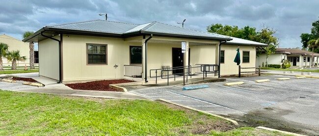
Property Record
700 N Central Ave, Umatilla, FL 32784


Current Lease Availabilities
NEARBY LISTINGS FOR SALE OR LEASE
Property Detail
700 N Central Ave
Orlando-Kissimmee-Sanford, FL
Umatilla Collins Sub
12-18-26-0400-00A-01700
UMATILLA COLLINS SUB N 1/2 OF LOT 16 LOTS 17 THRU 20 INCL BLK A PB 4 PG 22 ORB 4433 PG 1781 ORB 6535 PG 1313
Storemultistory
Lake
X
Florida
12069C0220E
17
2024
0.31 AC
2026
Lake County
030109
Orlando
1,632 SF
DEMOGRAPHICS near 700 N Central Ave
1 Mile
3 Mile
5 Mile
2024 Total Population
2,767
9,688
18,533
2029 Population
3,664
12,827
24,500
Pop Growth 2024-2029
+ 32.42%
+ 32.40%
+ 32.20%
Average Age
43
44
44
2024 Total Households
1,149
3,983
7,681
HH Growth 2024-2029
+ 32.64%
+ 32.76%
+ 32.43%
Median Household Inc
$66,685
$69,516
$69,014
Avg Household Size
2.40
2.40
2.40
2024 Avg HH Vehicles
2.00
2.00
2.00
Median Home Value
$261,904
$292,302
$294,514
Median Year Built
1985
1987
1987
Nearby Places
Map Layers
Map Styles
 Street
 Aerial
- Restaurants
- Banks
- Shops
- Fitness
- Groceries
PUBLIC TRANSPORTATION
AIRPORT
Orlando Sanford International
DRIVE
WALK
Distance
Orlando Sanford International
56 min
38.4 mi
Nearby Properties
Address
Land Use
TOTAL SIZE
Lot Size
Zoning
Address
Land Use
TOTAL SIZE
Lot Size
Zoning
601,069 SF
110.90 AC
CFD
Address
Land Use
TOTAL SIZE
Lot Size
Zoning
1,486.45 AC
A
Address
Land Use
TOTAL SIZE
Lot Size
Zoning
19,830 SF
69.88 AC
R3
Address
Land Use
TOTAL SIZE
Lot Size
Zoning
494,946 SF
57.60 AC
LM
Address
Land Use
TOTAL SIZE
Lot Size
Zoning
63,848 SF
6.80 AC
PFD
Address
Land Use
TOTAL SIZE
Lot Size
Zoning
2,000 SF
16.13 AC
PFD
Address
Land Use
TOTAL SIZE
Lot Size
Zoning
113,572 SF
21.17 AC
LM
Address
Land Use
TOTAL SIZE
Lot Size
Zoning
50,654 SF
9.83 AC
PFD
Address
Land Use
TOTAL SIZE
Lot Size
Zoning
60,034 SF
73.32 AC
AR
Address
Land Use
TOTAL SIZE
Lot Size
Zoning
48,132 SF
9.50 AC
C2
Address
Land Use
TOTAL SIZE
Lot Size
Zoning
2,000 SF
21.14 AC
PFD
Address
Land Use
TOTAL SIZE
Lot Size
Zoning
2,000 SF
28.22 AC
PFD
Address
Land Use
TOTAL SIZE
Lot Size
Zoning
24,800 SF
13.08 AC
Address
Land Use
TOTAL SIZE
Lot Size
Zoning
24,000 SF
2.67 AC
Address
Land Use
TOTAL SIZE
Lot Size
Zoning
14,012 SF
2.25 AC
RP
Address
Land Use
TOTAL SIZE
Lot Size
Zoning
25,077 SF
3.82 AC
LM
Address
Land Use
TOTAL SIZE
Lot Size
Zoning
20,382 SF
0.24 AC
C1
Address
Land Use
TOTAL SIZE
Lot Size
Zoning
21,577 SF
2.24 AC
C2
Address
Land Use
TOTAL SIZE
Lot Size
Zoning
35,550 SF
4.27 AC
HM
Address
Land Use
TOTAL SIZE
Lot Size
Zoning
24,120 SF
0.94 AC
PUD
Address
Land Use
TOTAL SIZE
Lot Size
Zoning
25,898 SF
3.64 AC
RP
Address
Land Use
TOTAL SIZE
Lot Size
Zoning
13,008 SF
1.83 AC
C2
Address
Land Use
TOTAL SIZE
Lot Size
Zoning
6,863 SF
0.70 AC
C2
Address
Land Use
TOTAL SIZE
Lot Size
Zoning
47.58 AC
R18
Address
Land Use
TOTAL SIZE
Lot Size
Zoning
18,170 SF
12.49 AC
A
Address
Land Use
TOTAL SIZE
Lot Size
Zoning
4,583 SF
11.51 AC
CP
Address
Land Use
TOTAL SIZE
Lot Size
Zoning
34,061 SF
4.51 AC
RP
Address
Land Use
TOTAL SIZE
Lot Size
Zoning
15,000 SF
1.84 AC
Address
Land Use
TOTAL SIZE
Lot Size
Zoning
11,512 SF
6.92 AC
PFD
Address
Land Use
TOTAL SIZE
Lot Size
Zoning
28,360 SF
2.76 AC
C2
The World's #1 Commercial Real Estate Marketplace
Connect with us
© 2025 CoStar Group
The information above has been obtained from sources believed reliable. While we do not doubt its accuracy we have not verified it and make no guarantee, warranty or representation about it. It is your responsibility to independently confirm its accuracy and completeness. Any projections, opinions, assumptions, or estimates used are for example only and do not represent the current or future performance of the property. The value of this transaction to you depends on tax and other factors which should be evaluated by your tax, financial, and legal advisors. You and your advisors should conduct a careful, independent investigation of the property to determine to your satisfaction the suitability of the property for your needs.