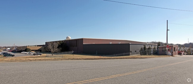
Property Record
700 N Main St, Kernersville, NC 27284
NEARBY LISTINGS FOR SALE OR LEASE
Property Detail
700 N Main St
Winston-Salem, NC
North Main Kernersville Commercials
6886-66-2425
OLD WEEKS PLANT LO:401 BL:5409 BU:1
Heavyindustrial
Forsyth
X
North Carolina
3710688600J
401
2024
38.80 AC
2025
Kernersville
003202
Greensboro/Winston-Salem
32,392 SF
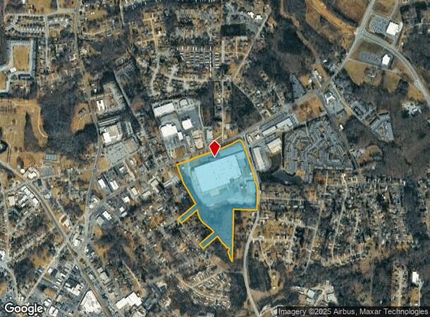
DEMOGRAPHICS near 700 N Main St
1 Mile
3 Mile
5 Mile
2024 Total Population
6,320
26,507
57,955
2029 Population
6,559
27,444
59,945
Pop Growth 2024-2029
+ 3.78%
+ 3.53%
+ 3.43%
Average Age
41
42
42
2024 Total Households
2,730
11,624
24,003
HH Growth 2024-2029
+ 3.77%
+ 3.58%
+ 3.51%
Median Household Inc
$47,839
$64,843
$76,339
Avg Household Size
2.30
2.20
2.40
2024 Avg HH Vehicles
2.00
2.00
2.00
Median Home Value
$190,866
$238,746
$246,416
Median Year Built
1986
1987
1990
Nearby Places
Map Layers
Map Styles
 Street
 Aerial
- Restaurants
- Banks
- Shops
- Fitness
- Groceries
PUBLIC TRANSPORTATION
AIRPORT
Piedmont Triad International
DRIVE
WALK
Distance
Piedmont Triad International
23 min
11.7 mi
Freight Ports
Virginia Port Authority - Richmond
DRIVE
WALK
Distance
Virginia Port Authority - Richmond
250 min
215.3 mi
SALE & LEASE HISTORY
LISTING DATE
SALE/LEASE

Nov 14, 2019
For Sale
Nearby Properties
Address
Land Use
TOTAL SIZE
Lot Size
Zoning
Address
Land Use
TOTAL SIZE
Lot Size
Zoning
179,681 SF
38.53 AC
MBP
Address
Land Use
TOTAL SIZE
Lot Size
Zoning
274,486 SF
30.31 AC
MBP
Address
Land Use
TOTAL SIZE
Lot Size
Zoning
1,001,670 SF
94.34 AC
BI
Address
Land Use
TOTAL SIZE
Lot Size
Zoning
667,440 SF
53.44 AC
BI
Address
Land Use
TOTAL SIZE
Lot Size
Zoning
777,963 SF
133.64 AC
BI
Address
Land Use
TOTAL SIZE
Lot Size
Zoning
576,252 SF
59.82 AC
GI,LI
Address
Land Use
TOTAL SIZE
Lot Size
Zoning
254,290 SF
21.12 AC
RM-12
Address
Land Use
TOTAL SIZE
Lot Size
Zoning
350,268 SF
30.53 AC
BI
Address
Land Use
TOTAL SIZE
Lot Size
Zoning
70,113 SF
19.06 AC
RM18-S
Address
Land Use
TOTAL SIZE
Lot Size
Zoning
115,838 SF
14.41 AC
GI-C
Address
Land Use
TOTAL SIZE
Lot Size
Zoning
129,895 SF
30.33 AC
RM18
Address
Land Use
TOTAL SIZE
Lot Size
Zoning
202,539 SF
23.70 AC
HB-S
Address
Land Use
TOTAL SIZE
Lot Size
Zoning
275,040 SF
28 AC
BI
Address
Land Use
TOTAL SIZE
Lot Size
Zoning
87,741 SF
15.44 AC
RM18
Address
Land Use
TOTAL SIZE
Lot Size
Zoning
545,857 SF
51.60 AC
GI
Address
Land Use
TOTAL SIZE
Lot Size
Zoning
451.32 AC
MU-C
Address
Land Use
TOTAL SIZE
Lot Size
Zoning
258,154 SF
39.55 AC
GI
Address
Land Use
TOTAL SIZE
Lot Size
Zoning
244,562 SF
29.92 AC
BI
Address
Land Use
TOTAL SIZE
Lot Size
Zoning
277,250 SF
30.15 AC
GI
Address
Land Use
TOTAL SIZE
Lot Size
Zoning
136,068 SF
19.46 AC
HB-S
Address
Land Use
TOTAL SIZE
Lot Size
Zoning
121,981 SF
14.48 AC
HB-S
Address
Land Use
TOTAL SIZE
Lot Size
Zoning
83,774 SF
7.51 AC
GB-S
Address
Land Use
TOTAL SIZE
Lot Size
Zoning
74,608 SF
8.68 AC
MBP
Address
Land Use
TOTAL SIZE
Lot Size
Zoning
160,179 SF
23.75 AC
LI-C,RS20
Address
Land Use
TOTAL SIZE
Lot Size
Zoning
603,494 SF
48.87 AC
LI
Address
Land Use
TOTAL SIZE
Lot Size
Zoning
122,682 SF
9.07 AC
HB-S
Address
Land Use
TOTAL SIZE
Lot Size
Zoning
43,286 SF
3.77 AC
RMU-S
Address
Land Use
TOTAL SIZE
Lot Size
Zoning
94,092 SF
15.31 AC
RM18
Address
Land Use
TOTAL SIZE
Lot Size
Zoning
203,069 SF
71.34 AC
GI
Address
Land Use
TOTAL SIZE
Lot Size
Zoning
93,437 SF
11.59 AC
HB-S
The World's #1 Commercial Real Estate Marketplace
Connect with us
© 2026 CoStar Group
The information above has been obtained from sources believed reliable. While we do not doubt its accuracy we have not verified it and make no guarantee, warranty or representation about it. It is your responsibility to independently confirm its accuracy and completeness. Any projections, opinions, assumptions, or estimates used are for example only and do not represent the current or future performance of the property. The value of this transaction to you depends on tax and other factors which should be evaluated by your tax, financial, and legal advisors. You and your advisors should conduct a careful, independent investigation of the property to determine to your satisfaction the suitability of the property for your needs.