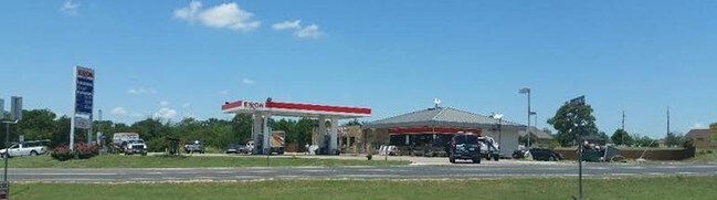
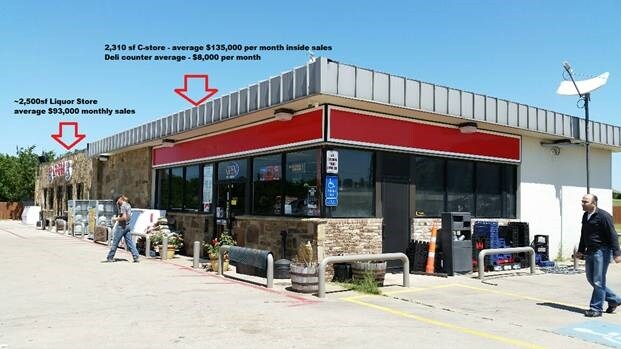
Property Record
700 N Main St, Maypearl, TX 76064

Property Detail
700 N Main St
Dallas-Fort Worth-Arlington, TX
LOT 2 BLK A CREEKVIEW HILLS 1.43 AC
149316
Ellis
Commercialnec
Texas
A Areas with a 1% annual chance of flooding and a 26% chance of flooding over the life of a 30-year mortgage.
2
2024
1.43 AC
2025
Southwest Outlying
060900
Dallas/Ft Worth
5,138 SF
NEARBY LISTINGS FOR SALE OR LEASE
-
-
View all Maypearl listings for sale on LoopNet.com
DEMOGRAPHICS near 700 N Main St
1 mile
3 mile
5 mile
2025 Total Population
335
2,381
7,071
2030 Population
383
2,731
8,128
Pop Growth 2025-2030
+ 14.33%
+ 14.70%
+ 14.95%
Average Age
40
40
40
2025 Total Households
111
797
2,366
HH Growth 2025-2030
+ 14.41%
+ 14.93%
+ 15.09%
Median Household Inc
$97,655
$96,643
$95,428
Avg Household Size
3.00
3.00
3.00
2025 Avg HH Vehicles
2.00
2.00
3.00
Median Home Value
$605,555
$627,958
$495,611
Median Year Built
1995
1997
1997
Nearby Places
Map Layers
Map Styles
 Street
 Aerial
Layers
 Traffic
 Biking
Places
Listings with unknown addresses are not visible on the map
- Restaurants
- Banks
- Shops
- Fitness
- Groceries
PUBLIC TRANSPORTATION
AIRPORT
Dallas Love Field
Drive
Walk
Distance
Dallas Love Field
55 min
46.1 mi
SALE & LEASE HISTORY
LISTING DATE
SALE/LEASE

Aug 17, 2017
For Sale
Nearby Properties
Address
Land Use
TOTAL SIZE
Lot Size
Zoning
Address
Land Use
TOTAL SIZE
Lot Size
Zoning
47,225 SF
63.40 AC
Address
Land Use
TOTAL SIZE
Lot Size
Zoning
74,175 SF
299.54 AC
Address
Land Use
TOTAL SIZE
Lot Size
Zoning
168,920 SF
34.98 AC
Address
Land Use
TOTAL SIZE
Lot Size
Zoning
126,687 SF
17.75 AC
Address
Land Use
TOTAL SIZE
Lot Size
Zoning
42,591 SF
19 AC
Address
Land Use
TOTAL SIZE
Lot Size
Zoning
25,020 SF
103.58 AC
Address
Land Use
TOTAL SIZE
Lot Size
Zoning
12,734 SF
509.19 AC
Address
Land Use
TOTAL SIZE
Lot Size
Zoning
4,745 SF
85.93 AC
Address
Land Use
TOTAL SIZE
Lot Size
Zoning
26,542 SF
4.27 AC
Address
Land Use
TOTAL SIZE
Lot Size
Zoning
7,244 SF
182.39 AC
Address
Land Use
TOTAL SIZE
Lot Size
Zoning
16,920 SF
1.74 AC
Address
Land Use
TOTAL SIZE
Lot Size
Zoning
11,440 SF
1.53 AC
Address
Land Use
TOTAL SIZE
Lot Size
Zoning
5,770 SF
20.08 AC
Address
Land Use
TOTAL SIZE
Lot Size
Zoning
9,100 SF
0.94 AC
Address
Land Use
TOTAL SIZE
Lot Size
Zoning
6,647 SF
111.05 AC
Address
Land Use
TOTAL SIZE
Lot Size
Zoning
13,005 SF
3.06 AC
Address
Land Use
TOTAL SIZE
Lot Size
Zoning
3,276 SF
21 AC
Address
Land Use
TOTAL SIZE
Lot Size
Zoning
6,718 SF
20.19 AC
Address
Land Use
TOTAL SIZE
Lot Size
Zoning
4,126 SF
208 AC
Address
Land Use
TOTAL SIZE
Lot Size
Zoning
8,364 SF
1.29 AC
Address
Land Use
TOTAL SIZE
Lot Size
Zoning
10,000 SF
5 AC
Address
Land Use
TOTAL SIZE
Lot Size
Zoning
11,282 SF
52.08 AC
Address
Land Use
TOTAL SIZE
Lot Size
Zoning
3,976 SF
25.69 AC
Address
Land Use
TOTAL SIZE
Lot Size
Zoning
8,848 SF
135.44 AC
Address
Land Use
TOTAL SIZE
Lot Size
Zoning
5,382 SF
150.77 AC
Address
Land Use
TOTAL SIZE
Lot Size
Zoning
49.39 AC
Address
Land Use
TOTAL SIZE
Lot Size
Zoning
3,659 SF
2.72 AC
Address
Land Use
TOTAL SIZE
Lot Size
Zoning
6,202 SF
314.83 AC
Address
Land Use
TOTAL SIZE
Lot Size
Zoning
5,468 SF
82.39 AC
Address
Land Use
TOTAL SIZE
Lot Size
Zoning
2,654 SF
73.64 AC
The World's #1 Commercial Real Estate Marketplace
Connect with us
© 2026 CoStar Group
The information above has been obtained from sources believed reliable. While we do not doubt its accuracy we have not verified it and make no guarantee, warranty or representation about it. It is your responsibility to independently confirm its accuracy and completeness. Any projections, opinions, assumptions, or estimates used are for example only and do not represent the current or future performance of the property. The value of this transaction to you depends on tax and other factors which should be evaluated by your tax, financial, and legal advisors. You and your advisors should conduct a careful, independent investigation of the property to determine to your satisfaction the suitability of the property for your needs.