Property Record
700 N Main St, Norwich, CT 06360
NEARBY LISTINGS FOR SALE OR LEASE
Property Detail
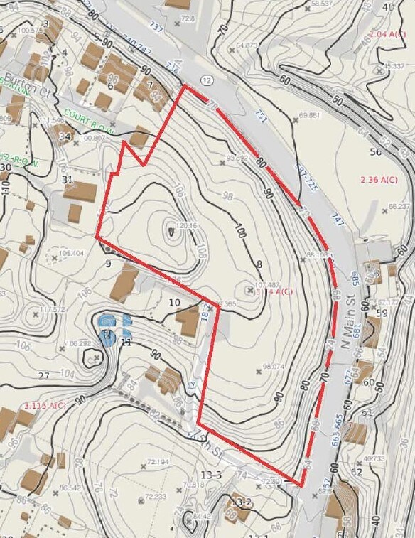
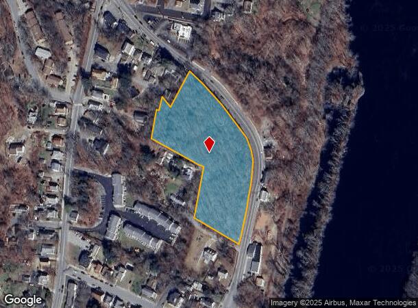
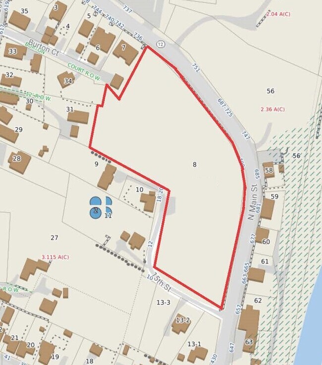
700 N Main St
NORW-000079-000002-000008
New London
Residentialacreage
Connecticut
X
8
09011C0216H
4.16 AC
2025
NE New London/Norwich
2025
Hartford
696401
Norwich-New London, CT
DEMOGRAPHICS near 700 N Main St
1 Mile
3 Mile
5 Mile
2024 Total Population
6,447
32,324
50,054
2029 Population
6,404
32,178
49,883
Pop Growth 2024-2029
(0.67%)
(0.45%)
(0.34%)
Average Age
38
40
41
2024 Total Households
2,569
13,345
20,606
HH Growth 2024-2029
(0.62%)
(0.51%)
(0.39%)
Median Household Inc
$43,928
$58,436
$65,272
Avg Household Size
2.40
2.30
2.30
2024 Avg HH Vehicles
2.00
2.00
2.00
Median Home Value
$179,031
$207,617
$221,100
Median Year Built
1958
1951
1959
Nearby Places
Map Layers
Map Styles
 Street
 Aerial
- Restaurants
- Banks
- Shops
- Fitness
- Groceries
SALE & LEASE HISTORY
LISTING DATE
SALE/LEASE

Apr 09, 2018
For Sale
Nearby Properties
Address
Land Use
TOTAL SIZE
Lot Size
Zoning
Address
Land Use
TOTAL SIZE
Lot Size
Zoning
200,847 SF
14.30 AC
R40
Address
Land Use
TOTAL SIZE
Lot Size
Zoning
16 AC
ROS
Address
Land Use
TOTAL SIZE
Lot Size
Zoning
Address
Land Use
TOTAL SIZE
Lot Size
Zoning
13.78 AC
R40
Address
Land Use
TOTAL SIZE
Lot Size
Zoning
179,652 SF
16.82 AC
PC
Address
Land Use
TOTAL SIZE
Lot Size
Zoning
16,551 SF
18.11 AC
MF
Address
Land Use
TOTAL SIZE
Lot Size
Zoning
54.97 AC
GC
Address
Land Use
TOTAL SIZE
Lot Size
Zoning
128,565 SF
18.90 AC
R40
Address
Land Use
TOTAL SIZE
Lot Size
Zoning
4.18 AC
R20
Address
Land Use
TOTAL SIZE
Lot Size
Zoning
8.78 AC
MF
Address
Land Use
TOTAL SIZE
Lot Size
Zoning
87,162 SF
30.20 AC
R20/MF
Address
Land Use
TOTAL SIZE
Lot Size
Zoning
152,265 SF
131 SF
ID
Address
Land Use
TOTAL SIZE
Lot Size
Zoning
151,735 SF
131 SF
ID
Address
Land Use
TOTAL SIZE
Lot Size
Zoning
6.39 AC
MF
Address
Land Use
TOTAL SIZE
Lot Size
Zoning
3.76 AC
MF
Address
Land Use
TOTAL SIZE
Lot Size
Zoning
351.80 AC
ROS
Address
Land Use
TOTAL SIZE
Lot Size
Zoning
70,639 SF
14 AC
R-80
Address
Land Use
TOTAL SIZE
Lot Size
Zoning
11.23 AC
MF
Address
Land Use
TOTAL SIZE
Lot Size
Zoning
3.85 AC
GC
Address
Land Use
TOTAL SIZE
Lot Size
Zoning
51,154 SF
0.38 AC
CC
Address
Land Use
TOTAL SIZE
Lot Size
Zoning
42,127 SF
0.63 AC
CC
Address
Land Use
TOTAL SIZE
Lot Size
Zoning
83,453 SF
5.80 AC
MF
Address
Land Use
TOTAL SIZE
Lot Size
Zoning
79,686 SF
0.13 AC
WD
Address
Land Use
TOTAL SIZE
Lot Size
Zoning
24.76 AC
R20
Address
Land Use
TOTAL SIZE
Lot Size
Zoning
78,364 SF
4.88 AC
GC
Address
Land Use
TOTAL SIZE
Lot Size
Zoning
3.28 AC
R20
Address
Land Use
TOTAL SIZE
Lot Size
Zoning
37,360 SF
2 AC
R20
Address
Land Use
TOTAL SIZE
Lot Size
Zoning
8.43 AC
R40
Address
Land Use
TOTAL SIZE
Lot Size
Zoning
67,512 SF
0.90 AC
CC
Address
Land Use
TOTAL SIZE
Lot Size
Zoning
46,612 SF
8.51 AC
GC
The World's #1 Commercial Real Estate Marketplace
Connect with us
© 2025 CoStar Group
The information above has been obtained from sources believed reliable. While we do not doubt its accuracy we have not verified it and make no guarantee, warranty or representation about it. It is your responsibility to independently confirm its accuracy and completeness. Any projections, opinions, assumptions, or estimates used are for example only and do not represent the current or future performance of the property. The value of this transaction to you depends on tax and other factors which should be evaluated by your tax, financial, and legal advisors. You and your advisors should conduct a careful, independent investigation of the property to determine to your satisfaction the suitability of the property for your needs.