Property Record
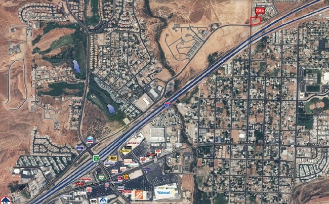
700 N Main St, Washington, UT 84780
Property Detail
700 N Main St
St. George, UT
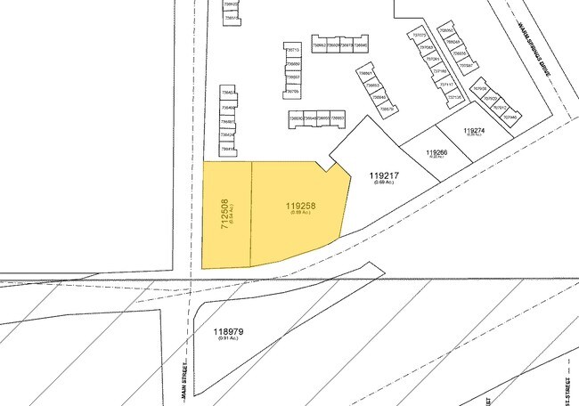
S: 11 T: 42S R: 15W PRPTY IN SEC 11 T42S R15W DESC AS FOL: BEG SW COR SE1/4 SW1/4 SEC 11 T42S R15W TH N0*3815 W 661.50 FT; TH S88*4415 W 139.93 FT; TH S02*2148 W 69.53 FT; TO 2011 FT RAD CUR LFT; TH ALG ARC CUR SLY 74.54 FT; TH S0*13 W 517.49 FT; TH
0119258
Washington
Commercialnec
Utah
C-2
0.96 AC
B and X Area of moderate flood hazard, usually the area between the limits of the 100-year and 500-year floods.
Cedar City & St George
2024
Other Market Areas
2025
NEARBY LISTINGS FOR SALE OR LEASE
DEMOGRAPHICS near 700 N Main St
1 mile
3 mile
5 mile
2025 Total Population
9,346
40,722
70,944
2030 Population
10,225
44,927
78,236
Pop Growth 2025-2030
+ 9.41%
+ 10.33%
+ 10.28%
Average Age
39
40
39
2025 Total Households
3,324
14,525
24,510
HH Growth 2025-2030
+ 9.96%
+ 10.89%
+ 10.68%
Median Household Inc
$90,155
$74,345
$74,159
Avg Household Size
2.80
2.70
2.80
2025 Avg HH Vehicles
2.00
2.00
2.00
Median Home Value
$493,696
$518,414
$550,032
Median Year Built
2003
2005
2004
Nearby Places
Map Layers
Map Styles
 Street
 Aerial
Layers
 Traffic
 Biking
Places
Listings with unknown addresses are not visible on the map
- Restaurants
- Banks
- Shops
- Fitness
- Groceries
PUBLIC TRANSPORTATION
AIRPORT
St George Regional
Drive
Walk
Distance
St George Regional
15 min
7.5 mi
Freight Ports
Port of Long Beach
Drive
Walk
Distance
Port of Long Beach
448 min
406.6 mi
Nearby Properties
Address
Land Use
TOTAL SIZE
Lot Size
Zoning
Address
Land Use
TOTAL SIZE
Lot Size
Zoning
470 SF
11,422.06 AC
OSC20
Address
Land Use
TOTAL SIZE
Lot Size
Zoning
319,351 SF
31.39 AC
PD
Address
Land Use
TOTAL SIZE
Lot Size
Zoning
319,351 SF
31.39 AC
Address
Land Use
TOTAL SIZE
Lot Size
Zoning
1,319 SF
549.51 AC
Address
Land Use
TOTAL SIZE
Lot Size
Zoning
230,880 SF
25.58 AC
C-2
Address
Land Use
TOTAL SIZE
Lot Size
Zoning
87,826 SF
37.27 AC
Address
Land Use
TOTAL SIZE
Lot Size
Zoning
97,572 SF
10.51 AC
PD
Address
Land Use
TOTAL SIZE
Lot Size
Zoning
86,875 SF
77.53 AC
Address
Land Use
TOTAL SIZE
Lot Size
Zoning
153,140 SF
17.17 AC
C-3
Address
Land Use
TOTAL SIZE
Lot Size
Zoning
72,862 SF
3.20 AC
Address
Land Use
TOTAL SIZE
Lot Size
Zoning
99,566 SF
5.64 AC
Address
Land Use
TOTAL SIZE
Lot Size
Zoning
137,662 SF
7.81 AC
PD
Address
Land Use
TOTAL SIZE
Lot Size
Zoning
111,865 SF
5 AC
M-2
Address
Land Use
TOTAL SIZE
Lot Size
Zoning
88,962 SF
8.35 AC
C-3
Address
Land Use
TOTAL SIZE
Lot Size
Zoning
115,050 SF
10.15 AC
C-2
Address
Land Use
TOTAL SIZE
Lot Size
Zoning
52,076 SF
4.81 AC
C-2
Address
Land Use
TOTAL SIZE
Lot Size
Zoning
31,955 SF
5.44 AC
C-2
Address
Land Use
TOTAL SIZE
Lot Size
Zoning
14,662 SF
31.24 AC
R110
Address
Land Use
TOTAL SIZE
Lot Size
Zoning
35,139 SF
3.85 AC
C-3
Address
Land Use
TOTAL SIZE
Lot Size
Zoning
188,536 SF
5.79 AC
M-2
Address
Land Use
TOTAL SIZE
Lot Size
Zoning
5,108 SF
19.79 AC
Address
Land Use
TOTAL SIZE
Lot Size
Zoning
35,680 SF
10.33 AC
Address
Land Use
TOTAL SIZE
Lot Size
Zoning
105,742 SF
2.31 AC
C-2
Address
Land Use
TOTAL SIZE
Lot Size
Zoning
25,380 SF
2.09 AC
I
Address
Land Use
TOTAL SIZE
Lot Size
Zoning
103,829 SF
5.88 AC
I
Address
Land Use
TOTAL SIZE
Lot Size
Zoning
57,732 SF
6.48 AC
Address
Land Use
TOTAL SIZE
Lot Size
Zoning
57,732 SF
6.48 AC
PD
Address
Land Use
TOTAL SIZE
Lot Size
Zoning
8,116 SF
26.26 AC
Address
Land Use
TOTAL SIZE
Lot Size
Zoning
35,122 SF
3.53 AC
The World's #1 Commercial Real Estate Marketplace
Connect with us
© 2026 CoStar Group
The information above has been obtained from sources believed reliable. While we do not doubt its accuracy we have not verified it and make no guarantee, warranty or representation about it. It is your responsibility to independently confirm its accuracy and completeness. Any projections, opinions, assumptions, or estimates used are for example only and do not represent the current or future performance of the property. The value of this transaction to you depends on tax and other factors which should be evaluated by your tax, financial, and legal advisors. You and your advisors should conduct a careful, independent investigation of the property to determine to your satisfaction the suitability of the property for your needs.