Property Record
700 N Us Highway 1, Oak Hill, FL 32759


NEARBY LISTINGS FOR SALE OR LEASE
-
-
View all Oak Hill listings for sale on LoopNet.com
Property Detail
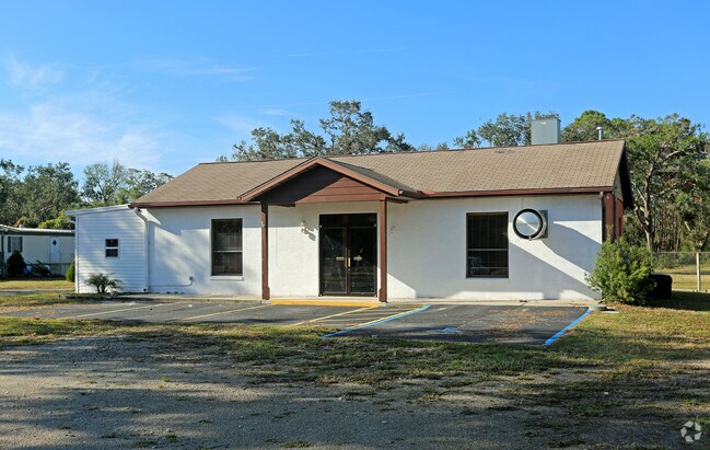
700 N Us Highway 1
Deltona-Daytona Beach-Ormond Beach, FL
St Between Same Marsh Sub
8531-02-03-0070
30 & 31-18-35 LOT 7 BLK 3 & LOT 10 BLK 1 W OF US 1 & VAC ST BETWEEN SAME MARSH SUB MB 17 PG 77 PER OR 5165 PG 4201 PER OR 7518 PG 2634 PER OR 8747 PG 0004
Servicestationmarket
Volusia
X
Florida
12127C0715J
7,10
2025
2.49 AC
2026
SE Volusia County
083003
Deltona/Daytona Beach
12,500 SF
DEMOGRAPHICS near 700 N Us Highway 1
1 Mile
3 Mile
5 Mile
2024 Total Population
1,680
6,463
18,915
2029 Population
1,895
7,268
21,224
Pop Growth 2024-2029
+ 12.80%
+ 12.46%
+ 12.21%
Average Age
55
54
50
2024 Total Households
817
3,062
8,411
HH Growth 2024-2029
+ 12.85%
+ 12.64%
+ 12.54%
Median Household Inc
$57,295
$56,573
$57,700
Avg Household Size
2.00
2.10
2.20
2024 Avg HH Vehicles
2.00
2.00
2.00
Median Home Value
$218,750
$217,857
$232,219
Median Year Built
1993
1993
1990
Nearby Places
Map Layers
Map Styles
 Street
 Aerial
- Restaurants
- Banks
- Shops
- Fitness
- Groceries
PUBLIC TRANSPORTATION
AIRPORT
Daytona Beach International
DRIVE
WALK
Distance
Daytona Beach International
40 min
29.0 mi
Orlando Sanford International
DRIVE
WALK
Distance
Orlando Sanford International
60 min
35.3 mi
Freight Ports
Port Canaveral
DRIVE
WALK
Distance
Port Canaveral
60 min
49.4 mi
SALE & LEASE HISTORY
LISTING DATE
SALE/LEASE

Jan 08, 2018
For Sale
Nearby Properties
Address
Land Use
TOTAL SIZE
Lot Size
Zoning
Address
Land Use
TOTAL SIZE
Lot Size
Zoning
26,187 SF
1.25 AC
01MH1
Address
Land Use
TOTAL SIZE
Lot Size
Zoning
504,830 SF
70.60 AC
I3W
Address
Land Use
TOTAL SIZE
Lot Size
Zoning
171,832 SF
13.56 AC
I3W
Address
Land Use
TOTAL SIZE
Lot Size
Zoning
76,446 SF
10.09 AC
11R1
Address
Land Use
TOTAL SIZE
Lot Size
Zoning
24,071 SF
0.63 AC
11R1
Address
Land Use
TOTAL SIZE
Lot Size
Zoning
631 AC
Address
Land Use
TOTAL SIZE
Lot Size
Zoning
45,088 SF
6.14 AC
01I1
Address
Land Use
TOTAL SIZE
Lot Size
Zoning
36,348 SF
9.37 AC
01I4
Address
Land Use
TOTAL SIZE
Lot Size
Zoning
41.90 AC
01B4
Address
Land Use
TOTAL SIZE
Lot Size
Zoning
411 AC
RCW
Address
Land Use
TOTAL SIZE
Lot Size
Zoning
8.82 AC
MH1W
Address
Land Use
TOTAL SIZE
Lot Size
Zoning
27.40 AC
Address
Land Use
TOTAL SIZE
Lot Size
Zoning
19,404 SF
5.28 AC
Address
Land Use
TOTAL SIZE
Lot Size
Zoning
10,350 SF
2 AC
Address
Land Use
TOTAL SIZE
Lot Size
Zoning
1,102 SF
12.63 AC
B7W
Address
Land Use
TOTAL SIZE
Lot Size
Zoning
5,288 SF
10.45 AC
MH5W
Address
Land Use
TOTAL SIZE
Lot Size
Zoning
4.03 AC
MH1W
Address
Land Use
TOTAL SIZE
Lot Size
Zoning
9,283 SF
2 AC
01B4
Address
Land Use
TOTAL SIZE
Lot Size
Zoning
4,808 SF
5.75 AC
01B4
Address
Land Use
TOTAL SIZE
Lot Size
Zoning
18,561 SF
2.75 AC
Address
Land Use
TOTAL SIZE
Lot Size
Zoning
15,627 SF
1.78 AC
01B4
Address
Land Use
TOTAL SIZE
Lot Size
Zoning
175.40 AC
CW
Address
Land Use
TOTAL SIZE
Lot Size
Zoning
Address
Land Use
TOTAL SIZE
Lot Size
Zoning
11,161 SF
1.40 AC
11R3
Address
Land Use
TOTAL SIZE
Lot Size
Zoning
37.17 AC
A3
Address
Land Use
TOTAL SIZE
Lot Size
Zoning
1,436 SF
3.44 AC
Address
Land Use
TOTAL SIZE
Lot Size
Zoning
16.40 AC
01I4
Address
Land Use
TOTAL SIZE
Lot Size
Zoning
9,100 SF
1.56 AC
11B3
Address
Land Use
TOTAL SIZE
Lot Size
Zoning
15,240 SF
14.25 AC
MH5
Address
Land Use
TOTAL SIZE
Lot Size
Zoning
3,633 SF
3.81 AC
The World's #1 Commercial Real Estate Marketplace
Connect with us
© 2026 CoStar Group
The information above has been obtained from sources believed reliable. While we do not doubt its accuracy we have not verified it and make no guarantee, warranty or representation about it. It is your responsibility to independently confirm its accuracy and completeness. Any projections, opinions, assumptions, or estimates used are for example only and do not represent the current or future performance of the property. The value of this transaction to you depends on tax and other factors which should be evaluated by your tax, financial, and legal advisors. You and your advisors should conduct a careful, independent investigation of the property to determine to your satisfaction the suitability of the property for your needs.