Property Record
700 Outback Way, Rail Road Flat, CA 95248


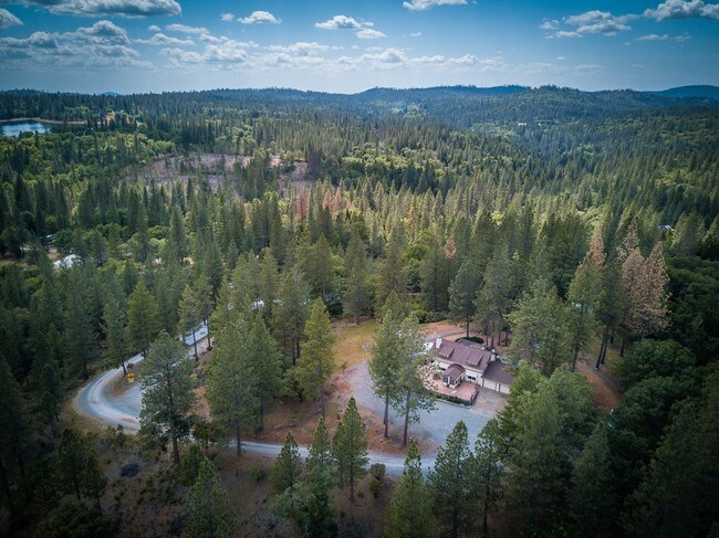
Property Detail
700 Outback Way
014-030-039-000
PCL 1 OF PM 7 113 IN 27 T6R13
Ranch
CALAVERAS
RA20
California
B and X Area of moderate flood hazard, usually the area between the limits of the 100-year and 500-year floods.
27
2025
40.68 AC
2025
Merced/Central
000400
Other Market Areas
1,613 SF
NEARBY LISTINGS FOR SALE OR LEASE
-
-
View all Rail Road Flat listings for sale on LoopNet.com
DEMOGRAPHICS near 700 Outback Way
1 mile
3 mile
5 mile
2025 Total Population
225
1,654
3,277
2030 Population
224
1,630
3,224
Pop Growth 2025-2030
(0.44%)
(1.45%)
(1.62%)
Average Age
52
50
50
2025 Total Households
102
749
1,446
HH Growth 2025-2030
(0.98%)
(1.60%)
(1.66%)
Median Household Inc
$87,999
$80,803
$70,925
Avg Household Size
2.10
2.20
2.20
2025 Avg HH Vehicles
3.00
3.00
3.00
Median Home Value
$397,726
$365,872
$354,861
Median Year Built
1980
1979
1978
Nearby Places
Map Layers
Map Styles
 Street
 Aerial
Layers
 Traffic
 Biking
Places
Listings with unknown addresses are not visible on the map
- Restaurants
- Banks
- Shops
- Fitness
- Groceries
SALE & LEASE HISTORY
LISTING DATE
SALE/LEASE

Jun 19, 2017
For Sale
Nearby Properties
Address
Land Use
TOTAL SIZE
Lot Size
Zoning
Address
Land Use
TOTAL SIZE
Lot Size
Zoning
81.30 AC
AP
Address
Land Use
TOTAL SIZE
Lot Size
Zoning
3,582 SF
80 AC
AP
Address
Land Use
TOTAL SIZE
Lot Size
Zoning
1,320 SF
6.22 AC
U
Address
Land Use
TOTAL SIZE
Lot Size
Zoning
1.46 AC
C2
Address
Land Use
TOTAL SIZE
Lot Size
Zoning
2,016 SF
23.13 AC
RA20
Address
Land Use
TOTAL SIZE
Lot Size
Zoning
6,417 SF
4.95 AC
U
Address
Land Use
TOTAL SIZE
Lot Size
Zoning
2,352 SF
40 AC
U
Address
Land Use
TOTAL SIZE
Lot Size
Zoning
1,680 SF
11.38 AC
RA20
Address
Land Use
TOTAL SIZE
Lot Size
Zoning
2,332 SF
9.41 AC
RA20
Address
Land Use
TOTAL SIZE
Lot Size
Zoning
2,354 SF
23.01 AC
U
Address
Land Use
TOTAL SIZE
Lot Size
Zoning
10.05 AC
Address
Land Use
TOTAL SIZE
Lot Size
Zoning
2,406 SF
5.07 AC
RR20
Address
Land Use
TOTAL SIZE
Lot Size
Zoning
2,640 SF
32.50 AC
RA20
Address
Land Use
TOTAL SIZE
Lot Size
Zoning
3,368 SF
5.24 AC
RA20
Address
Land Use
TOTAL SIZE
Lot Size
Zoning
1,258 SF
11.60 AC
RR20
Address
Land Use
TOTAL SIZE
Lot Size
Zoning
1,870 SF
7.50 AC
RA20
Address
Land Use
TOTAL SIZE
Lot Size
Zoning
5.42 AC
RR20
Address
Land Use
TOTAL SIZE
Lot Size
Zoning
1,813 SF
14.19 AC
RR5
Address
Land Use
TOTAL SIZE
Lot Size
Zoning
3,781 SF
11.35 AC
RR20
Address
Land Use
TOTAL SIZE
Lot Size
Zoning
20.04 AC
RA20
Address
Land Use
TOTAL SIZE
Lot Size
Zoning
2,059 SF
15.07 AC
RA20
Address
Land Use
TOTAL SIZE
Lot Size
Zoning
2,043 SF
5.07 AC
RR5
Address
Land Use
TOTAL SIZE
Lot Size
Zoning
2,413 SF
27.53 AC
RR20
Address
Land Use
TOTAL SIZE
Lot Size
Zoning
2,730 SF
11.20 AC
RA20
Address
Land Use
TOTAL SIZE
Lot Size
Zoning
1,684 SF
9.92 AC
U
Address
Land Use
TOTAL SIZE
Lot Size
Zoning
55.68 AC
Address
Land Use
TOTAL SIZE
Lot Size
Zoning
2,347 SF
5 AC
RA20
Address
Land Use
TOTAL SIZE
Lot Size
Zoning
864 SF
13.09 AC
RA
Address
Land Use
TOTAL SIZE
Lot Size
Zoning
3,668 SF
115.06 AC
AP
The World's #1 Commercial Real Estate Marketplace
Connect with us
© 2026 CoStar Group
The information above has been obtained from sources believed reliable. While we do not doubt its accuracy we have not verified it and make no guarantee, warranty or representation about it. It is your responsibility to independently confirm its accuracy and completeness. Any projections, opinions, assumptions, or estimates used are for example only and do not represent the current or future performance of the property. The value of this transaction to you depends on tax and other factors which should be evaluated by your tax, financial, and legal advisors. You and your advisors should conduct a careful, independent investigation of the property to determine to your satisfaction the suitability of the property for your needs.