Property Record
700 Pencader Dr, Newark, DE 19702
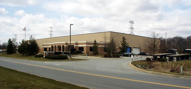

Property Detail
700 Pencader Dr
11-021.00-021
New Castle
Industrialgeneral
Delaware
BP
9
B and X Area of moderate flood hazard, usually the area between the limits of the 100-year and 500-year floods.
7.52 AC
2025
New Castle County
2025
Philadelphia
014814
Philadelphia-Camden-Wilmington, PA-NJ-DE-MD
34,348 SF
NEARBY LISTINGS FOR SALE OR LEASE
DEMOGRAPHICS near 700 Pencader Dr
1 mile
3 mile
5 mile
2025 Total Population
5,052
37,452
127,252
2030 Population
5,229
38,222
131,550
Pop Growth 2025-2030
+ 3.50%
+ 2.06%
+ 3.38%
Average Age
41
41
38
2025 Total Households
1,739
14,249
46,081
HH Growth 2025-2030
+ 3.74%
+ 2.13%
+ 3.55%
Median Household Inc
$122,246
$95,082
$86,394
Avg Household Size
2.90
2.60
2.60
2025 Avg HH Vehicles
2.00
2.00
2.00
Median Home Value
$396,090
$372,213
$347,681
Median Year Built
1996
1990
1990
Nearby Places
Map Layers
Map Styles
 Street
 Aerial
Layers
 Traffic
 Biking
Places
Listings with unknown addresses are not visible on the map
- Restaurants
- Banks
- Shops
- Fitness
- Groceries
PUBLIC TRANSPORTATION
COMMUTER RAIL
Newark (R2 - Southeastern Pennsylvania Transportation Authority Regional Rail (SEPTA Regional Rail))
Drive
Walk
Distance
Newark (R2 - Southeastern Pennsylvania Transportation Authority Regional Rail (SEPTA Regional Rail))
10 min
5.6 mi
Freight Ports
Port of Wilmington, RI
Drive
Walk
Distance
Port of Wilmington, RI
27 min
17.5 mi
Nearby Properties
Address
Land Use
TOTAL SIZE
Lot Size
Zoning
Address
Land Use
TOTAL SIZE
Lot Size
Zoning
226,878 SF
73.68 AC
CR
Address
Land Use
TOTAL SIZE
Lot Size
Zoning
161,018 SF
97.88 AC
OR
Address
Land Use
TOTAL SIZE
Lot Size
Zoning
766,520 SF
69.52 AC
BI
Address
Land Use
TOTAL SIZE
Lot Size
Zoning
59.70 AC
BP
Address
Land Use
TOTAL SIZE
Lot Size
Zoning
200,880 SF
49.83 AC
R3
Address
Land Use
TOTAL SIZE
Lot Size
Zoning
385,350 SF
43.51 AC
OR
Address
Land Use
TOTAL SIZE
Lot Size
Zoning
19.26 AC
RM
Address
Land Use
TOTAL SIZE
Lot Size
Zoning
266,818 SF
64.16 AC
BP
Address
Land Use
TOTAL SIZE
Lot Size
Zoning
281.01 AC
BP
Address
Land Use
TOTAL SIZE
Lot Size
Zoning
930 SF
52.69 AC
S
Address
Land Use
TOTAL SIZE
Lot Size
Zoning
15,168 SF
7.85 AC
NCAP
Address
Land Use
TOTAL SIZE
Lot Size
Zoning
392,955 SF
16.87 AC
NCAP
Address
Land Use
TOTAL SIZE
Lot Size
Zoning
20,250 SF
71.16 AC
S
Address
Land Use
TOTAL SIZE
Lot Size
Zoning
263,500 SF
15.28 AC
BI
Address
Land Use
TOTAL SIZE
Lot Size
Zoning
20,973 SF
75.14 AC
M1
Address
Land Use
TOTAL SIZE
Lot Size
Zoning
91,473 SF
59.44 AC
S
Address
Land Use
TOTAL SIZE
Lot Size
Zoning
294,288 SF
22.25 AC
NCAP
Address
Land Use
TOTAL SIZE
Lot Size
Zoning
81,072 SF
12.86 AC
RM
Address
Land Use
TOTAL SIZE
Lot Size
Zoning
124,986 SF
12.40 AC
18MI
Address
Land Use
TOTAL SIZE
Lot Size
Zoning
82,688 SF
11.30 AC
BI
Address
Land Use
TOTAL SIZE
Lot Size
Zoning
267,840 SF
20.35 AC
BI
Address
Land Use
TOTAL SIZE
Lot Size
Zoning
47.77 AC
OR
Address
Land Use
TOTAL SIZE
Lot Size
Zoning
153,556 SF
30.12 AC
OR
Address
Land Use
TOTAL SIZE
Lot Size
Zoning
3,680 SF
138.68 AC
S
Address
Land Use
TOTAL SIZE
Lot Size
Zoning
132,816 SF
7.11 AC
NCPUD
Address
Land Use
TOTAL SIZE
Lot Size
Zoning
145.78 AC
BP
Address
Land Use
TOTAL SIZE
Lot Size
Zoning
131,806 SF
21.97 AC
BI
Address
Land Use
TOTAL SIZE
Lot Size
Zoning
205,955 SF
24.91 AC
BI
Address
Land Use
TOTAL SIZE
Lot Size
Zoning
165,961 SF
8.95 AC
BP
Address
Land Use
TOTAL SIZE
Lot Size
Zoning
17.50 AC
R3
The World's #1 Commercial Real Estate Marketplace
Connect with us
© 2026 CoStar Group
The information above has been obtained from sources believed reliable. While we do not doubt its accuracy we have not verified it and make no guarantee, warranty or representation about it. It is your responsibility to independently confirm its accuracy and completeness. Any projections, opinions, assumptions, or estimates used are for example only and do not represent the current or future performance of the property. The value of this transaction to you depends on tax and other factors which should be evaluated by your tax, financial, and legal advisors. You and your advisors should conduct a careful, independent investigation of the property to determine to your satisfaction the suitability of the property for your needs.