Property Record
700 S Hosmer St, Lansing, MI 48912
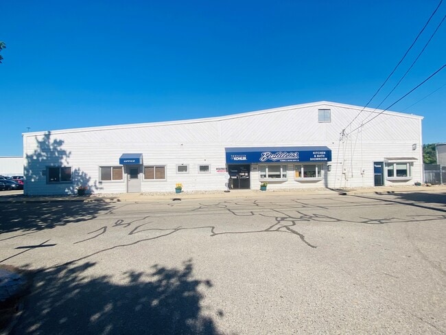
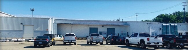
This Property Is For Sale
NEARBY LISTINGS FOR SALE OR LEASE
Property Detail
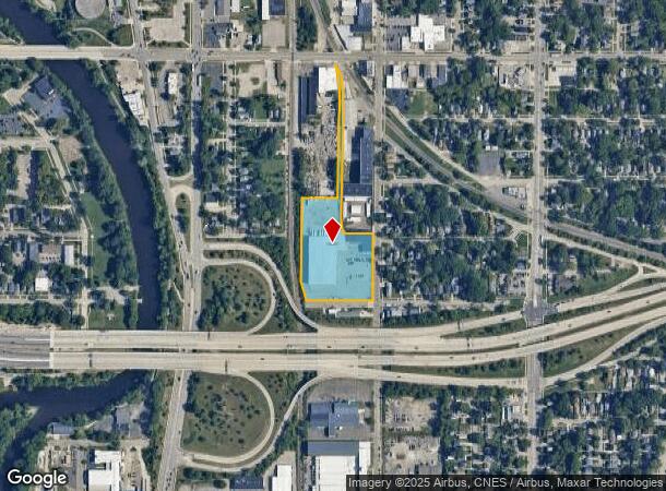
700 S Hosmer St
Lansing-East Lansing, MI
Assessors Plat #24
01-01-15-351-033
LOTS 6 THRU 10, ALSO ENTIRE 20 FT WIDE FORMER PM/GT RR SIDING & 16 FT WIDE FORMER LCRR SIDING LYING S OF KALAMAZOO ST AND N
Warehouse
Ingham
X
Michigan
26065C0131D
6-10
2024
4.80 AC
2025
Central Lansing
006600
West Michigan
40,440 SF
DEMOGRAPHICS near 700 S Hosmer St
1 Mile
3 Mile
5 Mile
2024 Total Population
12,506
91,473
196,184
2029 Population
12,657
91,629
196,385
Pop Growth 2024-2029
+ 1.21%
+ 0.17%
+ 0.10%
Average Age
36
36
36
2024 Total Households
5,936
39,471
85,095
HH Growth 2024-2029
+ 1.20%
+ 0.12%
+ 0.07%
Median Household Inc
$38,019
$47,330
$47,738
Avg Household Size
2.00
2.10
2.20
2024 Avg HH Vehicles
1.00
1.00
2.00
Median Home Value
$81,598
$116,295
$138,723
Median Year Built
1948
1955
1967
Nearby Places
- Restaurants
- Banks
- Shops
- Fitness
- Groceries
PUBLIC TRANSPORTATION
COMMUTER RAIL
East Lansing Amtrak Station (Blue Water - Amtrak)
DRIVE
WALK
Distance
East Lansing Amtrak Station (Blue Water - Amtrak)
6 min
3.0 mi
AIRPORT
Capital Region International
DRIVE
WALK
Distance
Capital Region International
11 min
5.1 mi
Freight Ports
Port of Toledo
DRIVE
WALK
Distance
Port of Toledo
145 min
114.2 mi
Nearby Properties
Address
Land Use
TOTAL SIZE
Lot Size
Zoning
Address
Land Use
TOTAL SIZE
Lot Size
Zoning
312,651 SF
37.50 AC
D-1 PRO
Address
Land Use
TOTAL SIZE
Lot Size
Zoning
42,875 SF
35 AC
PD
Address
Land Use
TOTAL SIZE
Lot Size
Zoning
42,875 SF
28.77 AC
Address
Land Use
TOTAL SIZE
Lot Size
Zoning
111,180 SF
3.63 AC
G-1 BUS
Address
Land Use
TOTAL SIZE
Lot Size
Zoning
14,304 SF
3.37 AC
MIXED Z
Address
Land Use
TOTAL SIZE
Lot Size
Zoning
274,720 SF
10.55 AC
Address
Land Use
TOTAL SIZE
Lot Size
Zoning
12,435 SF
0.52 AC
B3
Address
Land Use
TOTAL SIZE
Lot Size
Zoning
63,461 SF
32 AC
F COMM
Address
Land Use
TOTAL SIZE
Lot Size
Zoning
177,300 SF
8.72 AC
Address
Land Use
TOTAL SIZE
Lot Size
Zoning
69,851 SF
134.23 AC
I HVY
Address
Land Use
TOTAL SIZE
Lot Size
Zoning
13.13 AC
Address
Land Use
TOTAL SIZE
Lot Size
Zoning
66.43 AC
Address
Land Use
TOTAL SIZE
Lot Size
Zoning
195,094 SF
1.89 AC
Address
Land Use
TOTAL SIZE
Lot Size
Zoning
185,190 SF
0.41 AC
G-1 BUS
Address
Land Use
TOTAL SIZE
Lot Size
Zoning
150,589 SF
3.06 AC
D-1 PRO
Address
Land Use
TOTAL SIZE
Lot Size
Zoning
131,234 SF
2.49 AC
Address
Land Use
TOTAL SIZE
Lot Size
Zoning
9,628 SF
1.86 AC
B2
Address
Land Use
TOTAL SIZE
Lot Size
Zoning
332,832 SF
2.48 AC
G-1 BUS
Address
Land Use
TOTAL SIZE
Lot Size
Zoning
51,248 SF
4.85 AC
I HVY
Address
Land Use
TOTAL SIZE
Lot Size
Zoning
141,026 SF
0.45 AC
B3
Address
Land Use
TOTAL SIZE
Lot Size
Zoning
169,704 SF
0.67 AC
G-1 BUS
Address
Land Use
TOTAL SIZE
Lot Size
Zoning
63.94 AC
Address
Land Use
TOTAL SIZE
Lot Size
Zoning
165,684 SF
1.20 AC
G-1 BUS
Address
Land Use
TOTAL SIZE
Lot Size
Zoning
159,455 SF
0.42 AC
Address
Land Use
TOTAL SIZE
Lot Size
Zoning
112,248 SF
3.70 AC
B2
Address
Land Use
TOTAL SIZE
Lot Size
Zoning
157,548 SF
0.72 AC
Address
Land Use
TOTAL SIZE
Lot Size
Zoning
114,681 SF
1.08 AC
G-1 BUS
Address
Land Use
TOTAL SIZE
Lot Size
Zoning
131,040 SF
2.36 AC
Address
Land Use
TOTAL SIZE
Lot Size
Zoning
67,365 SF
4.19 AC
H LT IN
Address
Land Use
TOTAL SIZE
Lot Size
Zoning
The World's #1 Commercial Real Estate Marketplace
Connect with us
© 2025 CoStar Group
The information above has been obtained from sources believed reliable. While we do not doubt its accuracy we have not verified it and make no guarantee, warranty or representation about it. It is your responsibility to independently confirm its accuracy and completeness. Any projections, opinions, assumptions, or estimates used are for example only and do not represent the current or future performance of the property. The value of this transaction to you depends on tax and other factors which should be evaluated by your tax, financial, and legal advisors. You and your advisors should conduct a careful, independent investigation of the property to determine to your satisfaction the suitability of the property for your needs.