Property Record
700 S Main St, Euless, TX 76040

Save to a Folder
{{folder.Name}}
{{folder.ListingIds.length}} Properties
{{folder.ListingIds.length}} Property
Create a New Folder
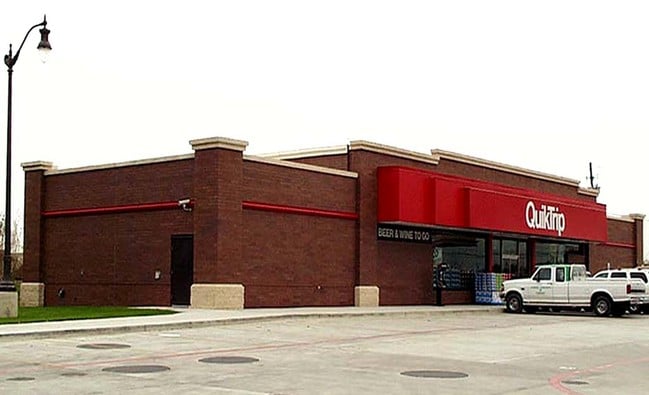
Property Detail
700 S Main St
Dallas-Fort Worth-Arlington, TX
CEDAR HILL ESTATES ADDITION BLOCK 8 LOT 22
00462497
TARRANT
Commercialnec
Texas
B and X Area of moderate flood hazard, usually the area between the limits of the 100-year and 500-year floods.
22
2025
0.29 AC
2025
Richland Hills
113513
Dallas/Ft Worth
3,586 SF
NEARBY LISTINGS FOR SALE OR LEASE
DEMOGRAPHICS near 700 S Main St
1 mile
3 mile
5 mile
2025 Total Population
18,200
93,546
254,516
2030 Population
19,219
98,731
267,238
Pop Growth 2025-2030
+ 5.60%
+ 5.54%
+ 5.00%
Average Age
37
37
38
2025 Total Households
6,925
40,066
107,858
HH Growth 2025-2030
+ 5.57%
+ 5.43%
+ 5.03%
Median Household Inc
$72,825
$78,263
$73,272
Avg Household Size
2.60
2.30
2.30
2025 Avg HH Vehicles
2.00
2.00
2.00
Median Home Value
$312,021
$372,603
$372,226
Median Year Built
1984
1990
1986
Nearby Places
Map Layers
Map Styles
 Street
 Aerial
Layers
 Traffic
 Biking
Places
Listings with unknown addresses are not visible on the map
- Restaurants
- Banks
- Shops
- Fitness
- Groceries
PUBLIC TRANSPORTATION
COMMUTER RAIL
Drive
Walk
Distance
7 min
2.8 mi
Drive
Walk
Distance
13 min
4.6 mi
AIRPORT
Dallas-Fort Worth International
Drive
Walk
Distance
Dallas-Fort Worth International
14 min
8.1 mi
Dallas Love Field
Drive
Walk
Distance
Dallas Love Field
25 min
16.8 mi
Nearby Properties
Address
Land Use
TOTAL SIZE
Lot Size
Zoning
Address
Land Use
TOTAL SIZE
Lot Size
Zoning
3,204,300 SF
124.04 AC
Address
Land Use
TOTAL SIZE
Lot Size
Zoning
1,344,594 SF
44.86 AC
Address
Land Use
TOTAL SIZE
Lot Size
Zoning
1,447,078 SF
41.52 AC
Address
Land Use
TOTAL SIZE
Lot Size
Zoning
468,250 SF
37.03 AC
Address
Land Use
TOTAL SIZE
Lot Size
Zoning
467,694 SF
24.03 AC
Address
Land Use
TOTAL SIZE
Lot Size
Zoning
415,563 SF
25.40 AC
Address
Land Use
TOTAL SIZE
Lot Size
Zoning
332,952 SF
13.54 AC
Address
Land Use
TOTAL SIZE
Lot Size
Zoning
516,974 SF
23.81 AC
Address
Land Use
TOTAL SIZE
Lot Size
Zoning
485,911 SF
54.76 AC
Address
Land Use
TOTAL SIZE
Lot Size
Zoning
521,200 SF
7.99 AC
Address
Land Use
TOTAL SIZE
Lot Size
Zoning
548,095 SF
7.19 AC
Address
Land Use
TOTAL SIZE
Lot Size
Zoning
522,294 SF
18.35 AC
Address
Land Use
TOTAL SIZE
Lot Size
Zoning
501,933 SF
16.25 AC
Address
Land Use
TOTAL SIZE
Lot Size
Zoning
443,420 SF
10.96 AC
Address
Land Use
TOTAL SIZE
Lot Size
Zoning
363,849 SF
8.08 AC
Address
Land Use
TOTAL SIZE
Lot Size
Zoning
591,105 SF
46.67 AC
Address
Land Use
TOTAL SIZE
Lot Size
Zoning
290,680 SF
26.31 AC
Address
Land Use
TOTAL SIZE
Lot Size
Zoning
294,296 SF
12.08 AC
Address
Land Use
TOTAL SIZE
Lot Size
Zoning
348,842 SF
17.09 AC
Address
Land Use
TOTAL SIZE
Lot Size
Zoning
266,586 SF
11.47 AC
Address
Land Use
TOTAL SIZE
Lot Size
Zoning
342,583 SF
23.87 AC
Address
Land Use
TOTAL SIZE
Lot Size
Zoning
344,326 SF
15.25 AC
Address
Land Use
TOTAL SIZE
Lot Size
Zoning
339,965 SF
15.59 AC
Address
Land Use
TOTAL SIZE
Lot Size
Zoning
282,665 SF
14.29 AC
Address
Land Use
TOTAL SIZE
Lot Size
Zoning
220,435 SF
14.97 AC
Address
Land Use
TOTAL SIZE
Lot Size
Zoning
285,194 SF
15.91 AC
Address
Land Use
TOTAL SIZE
Lot Size
Zoning
293,822 SF
18.80 AC
Address
Land Use
TOTAL SIZE
Lot Size
Zoning
223,131 SF
12.50 AC
Address
Land Use
TOTAL SIZE
Lot Size
Zoning
563,300 SF
27.40 AC
Z128
Address
Land Use
TOTAL SIZE
Lot Size
Zoning
253,710 SF
11.50 AC
The World's #1 Commercial Real Estate Marketplace
Connect with us
© 2026 CoStar Group
The information above has been obtained from sources believed reliable. While we do not doubt its accuracy we have not verified it and make no guarantee, warranty or representation about it. It is your responsibility to independently confirm its accuracy and completeness. Any projections, opinions, assumptions, or estimates used are for example only and do not represent the current or future performance of the property. The value of this transaction to you depends on tax and other factors which should be evaluated by your tax, financial, and legal advisors. You and your advisors should conduct a careful, independent investigation of the property to determine to your satisfaction the suitability of the property for your needs.