Property Record
700 W Beale St, Kingman, AZ 86401


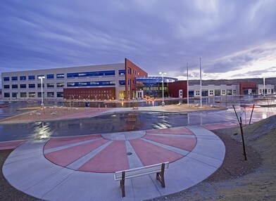
Property Detail
700 W Beale St
304-18-064
T21N R17W SEC 23 BEG AT A PT ON THE N-S MID-SECTION LINE N01 DEG 26E 1068 FROM S 1/4 CORNER; TH FOLLOWING COURSES & DISTANCES S8 9 DEG 56E 536.28; TH N01 DEG 26E 777.34; TH N83 DEG 32W 150. 0; TH S01 DEG 26W 454.06; TH N89 DEG 56W 386.82 TO N-S MID-S
Countyproperty
Mohave
AE The base floodplain where base flood elevations are provided. AE Zones are now used on new format FIRMs instead of A1-A30 Zones.
Arizona
0
35.08 AC
2027
Prescott & Sedona
953602
Other Market Areas
324,481 SF
Lake Havasu City-Kingman, AZ
NEARBY LISTINGS FOR SALE OR LEASE
DEMOGRAPHICS near 700 W Beale St
1 mile
3 mile
5 mile
2025 Total Population
1,970
12,585
30,525
2030 Population
2,036
12,800
31,237
Pop Growth 2025-2030
+ 3.35%
+ 1.71%
+ 2.33%
Average Age
44
43
44
2025 Total Households
805
5,068
12,231
HH Growth 2025-2030
+ 3.11%
+ 1.60%
+ 2.26%
Median Household Inc
$57,768
$52,447
$60,029
Avg Household Size
2.10
2.30
2.40
2025 Avg HH Vehicles
2.00
2.00
2.00
Median Home Value
$169,834
$199,268
$253,236
Median Year Built
1951
1978
1993
Nearby Places
Map Layers
Map Styles
 Street
 Aerial
Layers
 Traffic
 Biking
Places
Listings with unknown addresses are not visible on the map
- Restaurants
- Banks
- Shops
- Fitness
- Groceries
PUBLIC TRANSPORTATION
COMMUTER RAIL
Kingman (Southwest Chief - Amtrak)
Drive
Walk
Distance
Kingman (Southwest Chief - Amtrak)
2 min
19 min
1.0 mi
AIRPORT
Laughlin/Bullhead International
Drive
Walk
Distance
Laughlin/Bullhead International
49 min
34.7 mi
Freight Ports
Port of San Diego
Drive
Walk
Distance
Port of San Diego
413 min
362.1 mi
Nearby Properties
Address
Land Use
TOTAL SIZE
Lot Size
Zoning
Address
Land Use
TOTAL SIZE
Lot Size
Zoning
425,505 SF
26.14 AC
Address
Land Use
TOTAL SIZE
Lot Size
Zoning
117,905 SF
9.83 AC
Address
Land Use
TOTAL SIZE
Lot Size
Zoning
55,166 SF
2.34 AC
Address
Land Use
TOTAL SIZE
Lot Size
Zoning
124,168 SF
8.70 AC
Address
Land Use
TOTAL SIZE
Lot Size
Zoning
97,756 SF
9.98 AC
Address
Land Use
TOTAL SIZE
Lot Size
Zoning
48,720 SF
2.24 AC
Address
Land Use
TOTAL SIZE
Lot Size
Zoning
59,688 SF
2.24 AC
Address
Land Use
TOTAL SIZE
Lot Size
Zoning
80,602 SF
6.57 AC
Address
Land Use
TOTAL SIZE
Lot Size
Zoning
65,458 SF
1.82 AC
Address
Land Use
TOTAL SIZE
Lot Size
Zoning
109,899 SF
10.83 AC
Address
Land Use
TOTAL SIZE
Lot Size
Zoning
49,436 SF
4.35 AC
Address
Land Use
TOTAL SIZE
Lot Size
Zoning
53,642 SF
1.48 AC
Address
Land Use
TOTAL SIZE
Lot Size
Zoning
41,360 SF
4.37 AC
Address
Land Use
TOTAL SIZE
Lot Size
Zoning
69,082 SF
25.74 AC
Address
Land Use
TOTAL SIZE
Lot Size
Zoning
29,811 SF
2.76 AC
Address
Land Use
TOTAL SIZE
Lot Size
Zoning
15,078 SF
1.21 AC
Address
Land Use
TOTAL SIZE
Lot Size
Zoning
24,047 SF
3.83 AC
Address
Land Use
TOTAL SIZE
Lot Size
Zoning
62,846 SF
3.15 AC
Address
Land Use
TOTAL SIZE
Lot Size
Zoning
18,919 SF
3.25 AC
Address
Land Use
TOTAL SIZE
Lot Size
Zoning
19,546 SF
3 AC
Address
Land Use
TOTAL SIZE
Lot Size
Zoning
36,488 SF
2.44 AC
Address
Land Use
TOTAL SIZE
Lot Size
Zoning
20,996 SF
1.49 AC
Address
Land Use
TOTAL SIZE
Lot Size
Zoning
21,676 SF
2 AC
Address
Land Use
TOTAL SIZE
Lot Size
Zoning
17,179 SF
2.27 AC
Address
Land Use
TOTAL SIZE
Lot Size
Zoning
15,637 SF
1.73 AC
Address
Land Use
TOTAL SIZE
Lot Size
Zoning
15,570 SF
2.01 AC
Address
Land Use
TOTAL SIZE
Lot Size
Zoning
25,090 SF
2.84 AC
Address
Land Use
TOTAL SIZE
Lot Size
Zoning
14,456 SF
13.85 AC
Address
Land Use
TOTAL SIZE
Lot Size
Zoning
16,000 SF
2.72 AC
The World's #1 Commercial Real Estate Marketplace
Connect with us
© 2026 CoStar Group
The information above has been obtained from sources believed reliable. While we do not doubt its accuracy we have not verified it and make no guarantee, warranty or representation about it. It is your responsibility to independently confirm its accuracy and completeness. Any projections, opinions, assumptions, or estimates used are for example only and do not represent the current or future performance of the property. The value of this transaction to you depends on tax and other factors which should be evaluated by your tax, financial, and legal advisors. You and your advisors should conduct a careful, independent investigation of the property to determine to your satisfaction the suitability of the property for your needs.