Property Record
700 Walnut Forest Rd, Winston Salem, NC 27103

NEARBY LISTINGS FOR SALE OR LEASE
-
-
View all Winston Salem listings for sale on LoopNet.com
Property Detail
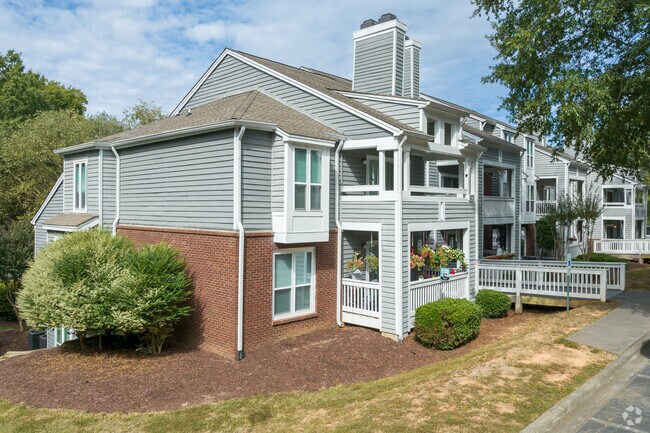
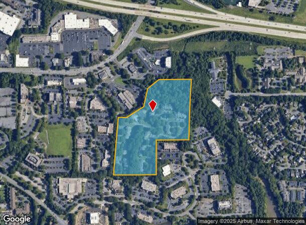
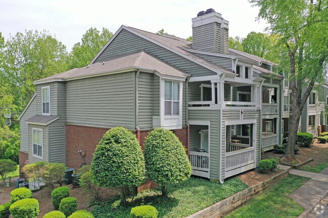
700 Walnut Forest Rd
Winston-Salem, NC
Highland Oaks Apts
6814-53-7516
HIGHLAND OAKS APTS LO:101 BL:3807B BU:1
Apartment
Forsyth
AE
North Carolina
3710681400J
101
2024
17.75 AC
2025
S Downtown Winston-Salem
003804
Greensboro/Winston-Salem
2,764 SF
DEMOGRAPHICS near 700 Walnut Forest Rd
1 mile
3 mile
5 mile
2024 Total Population
6,395
60,049
150,454
2029 Population
6,621
62,426
156,747
Pop Growth 2024-2029
+ 3.53%
+ 3.96%
+ 4.18%
Average Age
44
40
39
2024 Total Households
3,076
27,707
65,132
HH Growth 2024-2029
+ 3.58%
+ 4.01%
+ 4.26%
Median Household Inc
$57,787
$55,501
$59,133
Avg Household Size
2.00
2.10
2.20
2024 Avg HH Vehicles
1.00
2.00
2.00
Median Home Value
$160,283
$191,270
$217,404
Median Year Built
1987
1978
1979
Nearby Places
Map Layers
Map Styles
 Street
 Aerial
Transit
 Traffic
 Biking
Places
Listings with unknown addresses are not visible on the map
- Restaurants
- Banks
- Shops
- Fitness
- Groceries
PUBLIC TRANSPORTATION
AIRPORT
Piedmont Triad International
Drive
Walk
Distance
Piedmont Triad International
36 min
24.3 mi
Freight Ports
Port of Wilmington
Drive
Walk
Distance
Port of Wilmington
274 min
233.0 mi
Nearby Properties
Address
Land Use
TOTAL SIZE
Lot Size
Zoning
Address
Land Use
TOTAL SIZE
Lot Size
Zoning
133,360 SF
60.44 AC
C,RMU-S
Address
Land Use
TOTAL SIZE
Lot Size
Zoning
822,684 SF
33.33 AC
GB
Address
Land Use
TOTAL SIZE
Lot Size
Zoning
100 SF
2.59 AC
C
Address
Land Use
TOTAL SIZE
Lot Size
Zoning
123,109 SF
65.07 AC
C,HB,LO-S
Address
Land Use
TOTAL SIZE
Lot Size
Zoning
127,530 SF
2.52 AC
C
Address
Land Use
TOTAL SIZE
Lot Size
Zoning
100 SF
1.53 AC
C
Address
Land Use
TOTAL SIZE
Lot Size
Zoning
316,648 SF
30.46 AC
GB
Address
Land Use
TOTAL SIZE
Lot Size
Zoning
100 SF
2.71 AC
C
Address
Land Use
TOTAL SIZE
Lot Size
Zoning
125,328 SF
19.14 AC
RM18-S
Address
Land Use
TOTAL SIZE
Lot Size
Zoning
117,188 SF
12.22 AC
RM18
Address
Land Use
TOTAL SIZE
Lot Size
Zoning
205,778 SF
4.75 AC
GB
Address
Land Use
TOTAL SIZE
Lot Size
Zoning
138,636 SF
6.34 AC
RMU-S
Address
Land Use
TOTAL SIZE
Lot Size
Zoning
181,748 SF
7.58 AC
GO,GO-S
Address
Land Use
TOTAL SIZE
Lot Size
Zoning
160,152 SF
26 AC
RM12-S,RM1
Address
Land Use
TOTAL SIZE
Lot Size
Zoning
120,259 SF
13.68 AC
MU-S
Address
Land Use
TOTAL SIZE
Lot Size
Zoning
30,360 SF
17.09 AC
CPO-S
Address
Land Use
TOTAL SIZE
Lot Size
Zoning
297,487 SF
40.24 AC
RM12,RM18
Address
Land Use
TOTAL SIZE
Lot Size
Zoning
143,081 SF
4.88 AC
GB-S
Address
Land Use
TOTAL SIZE
Lot Size
Zoning
166,757 SF
5.89 AC
HB
Address
Land Use
TOTAL SIZE
Lot Size
Zoning
125,015 SF
33.69 AC
LO-S,RM8-S
Address
Land Use
TOTAL SIZE
Lot Size
Zoning
153,436 SF
17.46 AC
GB-S
Address
Land Use
TOTAL SIZE
Lot Size
Zoning
68,656 SF
6.25 AC
MU-S
Address
Land Use
TOTAL SIZE
Lot Size
Zoning
257,080 SF
23.47 AC
HB-S
Address
Land Use
TOTAL SIZE
Lot Size
Zoning
160,690 SF
17.81 AC
GB-S
Address
Land Use
TOTAL SIZE
Lot Size
Zoning
276,164 SF
27.55 AC
HB
Address
Land Use
TOTAL SIZE
Lot Size
Zoning
129,977 SF
7.51 AC
RM12-S
Address
Land Use
TOTAL SIZE
Lot Size
Zoning
59,612 SF
10.91 AC
MU-S
Address
Land Use
TOTAL SIZE
Lot Size
Zoning
75,095 SF
4.84 AC
HB,LO
Address
Land Use
TOTAL SIZE
Lot Size
Zoning
147,000 SF
5.77 AC
GB-S,LB
Address
Land Use
TOTAL SIZE
Lot Size
Zoning
88,466 SF
9.94 AC
GO-S
The World's #1 Commercial Real Estate Marketplace
Connect with us
© 2026 CoStar Group
The information above has been obtained from sources believed reliable. While we do not doubt its accuracy we have not verified it and make no guarantee, warranty or representation about it. It is your responsibility to independently confirm its accuracy and completeness. Any projections, opinions, assumptions, or estimates used are for example only and do not represent the current or future performance of the property. The value of this transaction to you depends on tax and other factors which should be evaluated by your tax, financial, and legal advisors. You and your advisors should conduct a careful, independent investigation of the property to determine to your satisfaction the suitability of the property for your needs.