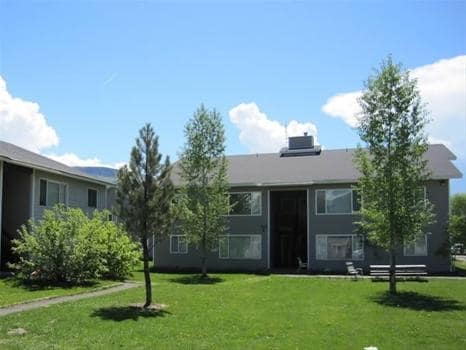
Property Record
700 Walton Pond Cir, Steamboat Springs, CO 80487

Property Detail
700 Walton Pond Cir
Steamboat Springs, CO
LOT 3 WALTON POND SUBD FILING 2
R6256643
ROUTT
Apartment
Colorado
AE The base floodplain where base flood elevations are provided. AE Zones are now used on new format FIRMs instead of A1-A30 Zones.
3
2025
14.97 AC
2025
Colorado Ski Area
000500
Other Market Areas
96,264 SF
NEARBY LISTINGS FOR SALE OR LEASE
DEMOGRAPHICS near 700 Walton Pond Cir
1 mile
3 mile
5 mile
2025 Total Population
4,774
12,968
16,151
2030 Population
5,035
13,404
16,520
Pop Growth 2025-2030
+ 5.47%
+ 3.36%
+ 2.28%
Average Age
41
43
42
2025 Total Households
2,232
5,715
6,833
HH Growth 2025-2030
+ 5.15%
+ 3.38%
+ 2.39%
Median Household Inc
$122,326
$119,033
$108,806
Avg Household Size
2.10
2.20
2.30
2025 Avg HH Vehicles
2.00
2.00
2.00
Median Home Value
$1,012,802
$1,047,254
$1,029,824
Median Year Built
1993
1993
1992
Nearby Places
Map Layers
Map Styles
 Street
 Aerial
Layers
 Traffic
 Biking
Places
Listings with unknown addresses are not visible on the map
- Restaurants
- Banks
- Shops
- Fitness
- Groceries
PUBLIC TRANSPORTATION
AIRPORT
Yampa Valley
Drive
Walk
Distance
Yampa Valley
34 min
27.6 mi
Nearby Properties
Address
Land Use
TOTAL SIZE
Lot Size
Zoning
Address
Land Use
TOTAL SIZE
Lot Size
Zoning
Address
Land Use
TOTAL SIZE
Lot Size
Zoning
50,497 SF
150 AC
Address
Land Use
TOTAL SIZE
Lot Size
Zoning
Address
Land Use
TOTAL SIZE
Lot Size
Zoning
195,194 SF
18.50 AC
Address
Land Use
TOTAL SIZE
Lot Size
Zoning
78,518 SF
2.80 AC
Address
Land Use
TOTAL SIZE
Lot Size
Zoning
89,146 SF
10.09 AC
Address
Land Use
TOTAL SIZE
Lot Size
Zoning
52,850 SF
1.92 AC
Z14
Address
Land Use
TOTAL SIZE
Lot Size
Zoning
254,414 SF
3.87 AC
Address
Land Use
TOTAL SIZE
Lot Size
Zoning
21,800 SF
232.64 AC
Address
Land Use
TOTAL SIZE
Lot Size
Zoning
Address
Land Use
TOTAL SIZE
Lot Size
Zoning
19,214 SF
59.28 AC
Address
Land Use
TOTAL SIZE
Lot Size
Zoning
72,111 SF
2.93 AC
Address
Land Use
TOTAL SIZE
Lot Size
Zoning
22,707 SF
5 AC
Address
Land Use
TOTAL SIZE
Lot Size
Zoning
35.10 AC
AF
Address
Land Use
TOTAL SIZE
Lot Size
Zoning
13,325 SF
5.98 AC
Address
Land Use
TOTAL SIZE
Lot Size
Zoning
59,305 SF
4.64 AC
Address
Land Use
TOTAL SIZE
Lot Size
Zoning
25,310 SF
1.27 AC
Address
Land Use
TOTAL SIZE
Lot Size
Zoning
34,665 SF
0.86 AC
Address
Land Use
TOTAL SIZE
Lot Size
Zoning
84,533 SF
14.65 AC
Address
Land Use
TOTAL SIZE
Lot Size
Zoning
20,957 SF
0.64 AC
Address
Land Use
TOTAL SIZE
Lot Size
Zoning
67,489 SF
7 AC
Address
Land Use
TOTAL SIZE
Lot Size
Zoning
42,462 SF
0.91 AC
Address
Land Use
TOTAL SIZE
Lot Size
Zoning
22,796 SF
0.64 AC
Address
Land Use
TOTAL SIZE
Lot Size
Zoning
13,660 SF
6.12 AC
AF
Address
Land Use
TOTAL SIZE
Lot Size
Zoning
53,405 SF
2.35 AC
RO
Address
Land Use
TOTAL SIZE
Lot Size
Zoning
12,676 SF
2.30 AC
Address
Land Use
TOTAL SIZE
Lot Size
Zoning
63,527 SF
3.88 AC
Address
Land Use
TOTAL SIZE
Lot Size
Zoning
19,888 SF
0.88 AC
Address
Land Use
TOTAL SIZE
Lot Size
Zoning
111,678 SF
4.20 AC
The World's #1 Commercial Real Estate Marketplace
Connect with us
© 2026 CoStar Group
The information above has been obtained from sources believed reliable. While we do not doubt its accuracy we have not verified it and make no guarantee, warranty or representation about it. It is your responsibility to independently confirm its accuracy and completeness. Any projections, opinions, assumptions, or estimates used are for example only and do not represent the current or future performance of the property. The value of this transaction to you depends on tax and other factors which should be evaluated by your tax, financial, and legal advisors. You and your advisors should conduct a careful, independent investigation of the property to determine to your satisfaction the suitability of the property for your needs.