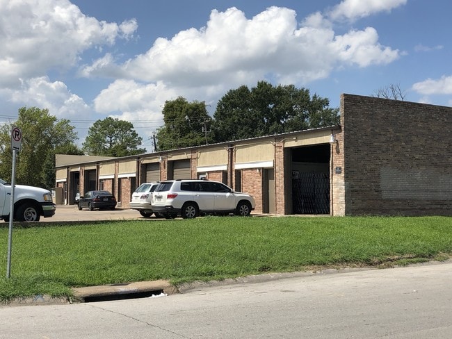
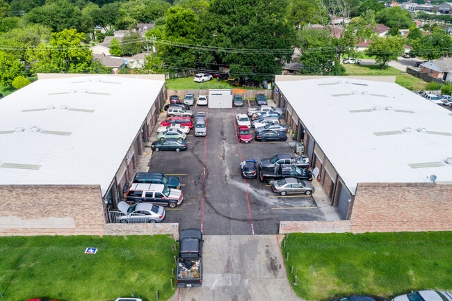
Property Record
7000 Baneway Dr, Houston, TX 77072

Current Lease Availabilities
Property Detail
7000 Baneway Dr
0991260000002
RES B & B1 BANEWAY
Warehouse
HARRIS
AE The base floodplain where base flood elevations are provided. AE Zones are now used on new format FIRMs instead of A1-A30 Zones.
Texas
2024
1.09 AC
2025
Southwest Outer Loop
453002
Houston
20,400 SF
Houston-Pasadena-The Woodlands, TX
NEARBY LISTINGS FOR SALE OR LEASE
DEMOGRAPHICS near 7000 Baneway Dr
1 mile
3 mile
5 mile
2025 Total Population
25,300
245,793
564,617
2030 Population
26,805
260,770
604,317
Pop Growth 2025-2030
+ 5.95%
+ 6.09%
+ 7.03%
Average Age
38
36
37
2025 Total Households
7,636
89,699
211,701
HH Growth 2025-2030
+ 6.18%
+ 6.34%
+ 7.22%
Median Household Inc
$54,977
$49,468
$56,940
Avg Household Size
3.20
2.70
2.60
2025 Avg HH Vehicles
2.00
2.00
2.00
Median Home Value
$188,071
$223,517
$273,255
Median Year Built
1976
1983
1983
Nearby Places
Map Layers
Map Styles
 Street
 Aerial
Transit
 Traffic
 Biking
Places
Listings with unknown addresses are not visible on the map
- Restaurants
- Banks
- Shops
- Fitness
- Groceries
PUBLIC TRANSPORTATION
AIRPORT
William P Hobby
Drive
Walk
Distance
William P Hobby
39 min
25.9 mi
George Bush Intcntl/Houston
Drive
Walk
Distance
George Bush Intcntl/Houston
42 min
34.1 mi
Freight Ports
Port of Houston
Drive
Walk
Distance
Port of Houston
38 min
24.9 mi
Nearby Properties
Address
Land Use
TOTAL SIZE
Lot Size
Zoning
Address
Land Use
TOTAL SIZE
Lot Size
Zoning
2,198,376 SF
14.18 AC
Address
Land Use
TOTAL SIZE
Lot Size
Zoning
1,020,766 SF
3.08 AC
Address
Land Use
TOTAL SIZE
Lot Size
Zoning
1,082,545 SF
7.22 AC
Address
Land Use
TOTAL SIZE
Lot Size
Zoning
430,096 SF
18.99 AC
Address
Land Use
TOTAL SIZE
Lot Size
Zoning
878,129 SF
11.69 AC
Address
Land Use
TOTAL SIZE
Lot Size
Zoning
627,632 SF
24.12 AC
Address
Land Use
TOTAL SIZE
Lot Size
Zoning
526,410 SF
20.43 AC
Address
Land Use
TOTAL SIZE
Lot Size
Zoning
367,309 SF
14.72 AC
Address
Land Use
TOTAL SIZE
Lot Size
Zoning
497,267 SF
24.69 AC
Address
Land Use
TOTAL SIZE
Lot Size
Zoning
380,423 SF
15.14 AC
Address
Land Use
TOTAL SIZE
Lot Size
Zoning
188,178 SF
18.49 AC
Address
Land Use
TOTAL SIZE
Lot Size
Zoning
771,720 SF
19.28 AC
Address
Land Use
TOTAL SIZE
Lot Size
Zoning
344,088 SF
13.77 AC
Address
Land Use
TOTAL SIZE
Lot Size
Zoning
598,127 SF
4.14 AC
Address
Land Use
TOTAL SIZE
Lot Size
Zoning
362,473 SF
15.65 AC
Address
Land Use
TOTAL SIZE
Lot Size
Zoning
539,308 SF
21 AC
Address
Land Use
TOTAL SIZE
Lot Size
Zoning
997,813 SF
5.25 AC
Address
Land Use
TOTAL SIZE
Lot Size
Zoning
351,042 SF
5 AC
Address
Land Use
TOTAL SIZE
Lot Size
Zoning
309,704 SF
8.84 AC
Address
Land Use
TOTAL SIZE
Lot Size
Zoning
354,203 SF
3.29 AC
Address
Land Use
TOTAL SIZE
Lot Size
Zoning
526,945 SF
23.05 AC
Address
Land Use
TOTAL SIZE
Lot Size
Zoning
700,828 SF
3.82 AC
Address
Land Use
TOTAL SIZE
Lot Size
Zoning
379,078 SF
14.83 AC
Address
Land Use
TOTAL SIZE
Lot Size
Zoning
394,544 SF
2.62 AC
Address
Land Use
TOTAL SIZE
Lot Size
Zoning
283,782 SF
11.57 AC
Address
Land Use
TOTAL SIZE
Lot Size
Zoning
323,438 SF
8.24 AC
Address
Land Use
TOTAL SIZE
Lot Size
Zoning
697,180 SF
2.90 AC
Address
Land Use
TOTAL SIZE
Lot Size
Zoning
843,830 SF
28.57 AC
Address
Land Use
TOTAL SIZE
Lot Size
Zoning
665,550 SF
3.58 AC
Address
Land Use
TOTAL SIZE
Lot Size
Zoning
340,944 SF
12.88 AC
The World's #1 Commercial Real Estate Marketplace
Connect with us
© 2026 CoStar Group
The information above has been obtained from sources believed reliable. While we do not doubt its accuracy we have not verified it and make no guarantee, warranty or representation about it. It is your responsibility to independently confirm its accuracy and completeness. Any projections, opinions, assumptions, or estimates used are for example only and do not represent the current or future performance of the property. The value of this transaction to you depends on tax and other factors which should be evaluated by your tax, financial, and legal advisors. You and your advisors should conduct a careful, independent investigation of the property to determine to your satisfaction the suitability of the property for your needs.