Property Record
7000 College Ave, Bakersfield, CA 93306
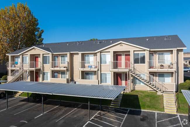


Property Detail
7000 College Ave
435-010-17-00-3
PARCEL MAP 4921 , LOT PTN4
Apartment
Kern
PUD
California
B and X Area of moderate flood hazard, usually the area between the limits of the 100-year and 500-year floods.
ptn4
2024
7.98 AC
2025
Eastridge Estates
000912
Bakersfield
93,070 SF
Bakersfield-Delano, CA
NEARBY LISTINGS FOR SALE OR LEASE
DEMOGRAPHICS near 7000 College Ave
1 mile
3 mile
5 mile
2025 Total Population
12,292
98,230
163,614
2030 Population
12,455
99,454
165,651
Pop Growth 2025-2030
+ 1.33%
+ 1.25%
+ 1.25%
Average Age
35
34
34
2025 Total Households
3,752
28,834
48,907
HH Growth 2025-2030
+ 1.33%
+ 1.23%
+ 1.27%
Median Household Inc
$59,602
$62,062
$54,888
Avg Household Size
3.20
3.30
3.20
2025 Avg HH Vehicles
2.00
2.00
2.00
Median Home Value
$304,127
$308,583
$302,880
Median Year Built
1977
1975
1974
Nearby Places
Map Layers
Map Styles
 Street
 Aerial
Layers
 Traffic
 Biking
Places
Listings with unknown addresses are not visible on the map
- Restaurants
- Banks
- Shops
- Fitness
- Groceries
PUBLIC TRANSPORTATION
COMMUTER RAIL
Bakersfield (San Joaquins - Amtrak)
Drive
Walk
Distance
Bakersfield (San Joaquins - Amtrak)
12 min
5.9 mi
AIRPORT
Meadows Field
Drive
Walk
Distance
Meadows Field
23 min
12.3 mi
Freight Ports
The Port of Hueneme
Drive
Walk
Distance
The Port of Hueneme
163 min
129.1 mi
Nearby Properties
Address
Land Use
TOTAL SIZE
Lot Size
Zoning
Address
Land Use
TOTAL SIZE
Lot Size
Zoning
18,000 SF
35.01 AC
M-2
Address
Land Use
TOTAL SIZE
Lot Size
Zoning
1.38 AC
C-2
Address
Land Use
TOTAL SIZE
Lot Size
Zoning
66,139 SF
4.48 AC
CO
Address
Land Use
TOTAL SIZE
Lot Size
Zoning
Address
Land Use
TOTAL SIZE
Lot Size
Zoning
112,052 SF
3.14 AC
R3
Address
Land Use
TOTAL SIZE
Lot Size
Zoning
66,139 SF
4.48 AC
CO
Address
Land Use
TOTAL SIZE
Lot Size
Zoning
161,946 SF
17.84 AC
C2 PD
Address
Land Use
TOTAL SIZE
Lot Size
Zoning
103,536 SF
6.31 AC
R-3
Address
Land Use
TOTAL SIZE
Lot Size
Zoning
50,445 SF
2.53 AC
C2
Address
Land Use
TOTAL SIZE
Lot Size
Zoning
102,262 SF
3.93 AC
Address
Land Use
TOTAL SIZE
Lot Size
Zoning
10.31 AC
Address
Land Use
TOTAL SIZE
Lot Size
Zoning
127,224 SF
7 AC
R-2/PUD
Address
Land Use
TOTAL SIZE
Lot Size
Zoning
137,900 SF
15.69 AC
C2
Address
Land Use
TOTAL SIZE
Lot Size
Zoning
115,058 SF
13.02 AC
C2
Address
Land Use
TOTAL SIZE
Lot Size
Zoning
1.06 AC
R-1
Address
Land Use
TOTAL SIZE
Lot Size
Zoning
0.41 AC
R1
Address
Land Use
TOTAL SIZE
Lot Size
Zoning
33,264 SF
28.68 AC
AG
Address
Land Use
TOTAL SIZE
Lot Size
Zoning
66,582 SF
3.36 AC
R-2
Address
Land Use
TOTAL SIZE
Lot Size
Zoning
179,460 SF
10.20 AC
R3
Address
Land Use
TOTAL SIZE
Lot Size
Zoning
68,264 SF
6.56 AC
C2
Address
Land Use
TOTAL SIZE
Lot Size
Zoning
4.94 AC
R-3
Address
Land Use
TOTAL SIZE
Lot Size
Zoning
74,038 SF
6.64 AC
C2
Address
Land Use
TOTAL SIZE
Lot Size
Zoning
46,522 SF
3.35 AC
R2
Address
Land Use
TOTAL SIZE
Lot Size
Zoning
34,733 SF
7.25 AC
C2
Address
Land Use
TOTAL SIZE
Lot Size
Zoning
29,440 SF
2.83 AC
C-2
Address
Land Use
TOTAL SIZE
Lot Size
Zoning
101,437 SF
9.05 AC
PCD
Address
Land Use
TOTAL SIZE
Lot Size
Zoning
96,952 SF
2.56 AC
R-2
Address
Land Use
TOTAL SIZE
Lot Size
Zoning
11.05 AC
C2/PCD
Address
Land Use
TOTAL SIZE
Lot Size
Zoning
95,258 SF
5.34 AC
PUD
Address
Land Use
TOTAL SIZE
Lot Size
Zoning
132,044 SF
9.07 AC
R-3
The World's #1 Commercial Real Estate Marketplace
Connect with us
© 2026 CoStar Group
The information above has been obtained from sources believed reliable. While we do not doubt its accuracy we have not verified it and make no guarantee, warranty or representation about it. It is your responsibility to independently confirm its accuracy and completeness. Any projections, opinions, assumptions, or estimates used are for example only and do not represent the current or future performance of the property. The value of this transaction to you depends on tax and other factors which should be evaluated by your tax, financial, and legal advisors. You and your advisors should conduct a careful, independent investigation of the property to determine to your satisfaction the suitability of the property for your needs.