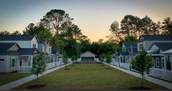
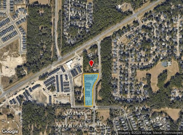
Property Record
7000 Sw 88Th St, Gainesville, FL 32608
NEARBY LISTINGS FOR SALE OR LEASE
-
-
View all Gainesville listings for sale on LoopNet.com
Property Detail
7000 Sw 88Th St
07061-008-000
Haile Lt 65 A Condo
Multifamilydwelling
COM SW COR SEC N 00 DEG 10 MIN 44 SEC W 778.97 FT N 58 DEG 25 MIN 53 SEC E 792.65 FT S 02 DEG 46 MIN 04 SEC E 463.03 FT POB S 02 DEG 46 MIN 04 DEC E 725.67 FT N 89 DEG 28 MIN 52 SEC E 420.40 FT N 02 DEG 47 MIN 04 SEC W 742.29 FT S 87 DEG 12 MIN 56 SE
X
Alachua
12001C0435E
Florida
2025
3.83 AC
2025
South Gainesville
002209
Other Market Areas
31,849 SF
Gainesville, FL
DEMOGRAPHICS near 7000 Sw 88Th St
1 Mile
3 Mile
5 Mile
2024 Total Population
3,714
23,716
76,048
2029 Population
3,913
25,322
80,432
Pop Growth 2024-2029
+ 5.36%
+ 6.77%
+ 5.76%
Average Age
38
40
35
2024 Total Households
1,443
9,628
31,275
HH Growth 2024-2029
+ 5.41%
+ 6.93%
+ 5.76%
Median Household Inc
$117,962
$102,605
$57,985
Avg Household Size
2.50
2.40
2.30
2024 Avg HH Vehicles
2.00
2.00
2.00
Median Home Value
$322,180
$346,294
$325,259
Median Year Built
2003
1998
1993
Nearby Places
Map Layers
Map Styles
 Street
 Aerial
- Restaurants
- Banks
- Shops
- Fitness
- Groceries
PUBLIC TRANSPORTATION
AIRPORT
Gainesville Regional
DRIVE
WALK
Distance
Gainesville Regional
30 min
13.7 mi
Freight Ports
Jacksonville Port
DRIVE
WALK
Distance
Jacksonville Port
115 min
83.5 mi
Nearby Properties
Address
Land Use
TOTAL SIZE
Lot Size
Zoning
Address
Land Use
TOTAL SIZE
Lot Size
Zoning
371,933 SF
15 AC
PD
Address
Land Use
TOTAL SIZE
Lot Size
Zoning
332,878 SF
34.15 AC
PD
Address
Land Use
TOTAL SIZE
Lot Size
Zoning
205,412 SF
23.80 AC
R-1A
Address
Land Use
TOTAL SIZE
Lot Size
Zoning
309,967 SF
12.58 AC
PD
Address
Land Use
TOTAL SIZE
Lot Size
Zoning
307,316 SF
25.99 AC
R-2
Address
Land Use
TOTAL SIZE
Lot Size
Zoning
112,213 SF
18.62 AC
R-1AA
Address
Land Use
TOTAL SIZE
Lot Size
Zoning
87,104 SF
14.59 AC
PD
Address
Land Use
TOTAL SIZE
Lot Size
Zoning
311,290 SF
25.20 AC
R-1A
Address
Land Use
TOTAL SIZE
Lot Size
Zoning
97,648 SF
44.62 AC
A
Address
Land Use
TOTAL SIZE
Lot Size
Zoning
64,710 SF
8.30 AC
PD
Address
Land Use
TOTAL SIZE
Lot Size
Zoning
133,104 SF
66.88 AC
RM
Address
Land Use
TOTAL SIZE
Lot Size
Zoning
98,278 SF
3.40 AC
MP
Address
Land Use
TOTAL SIZE
Lot Size
Zoning
17,640 SF
7.23 AC
PD
Address
Land Use
TOTAL SIZE
Lot Size
Zoning
82,635 SF
16.64 AC
R-2
Address
Land Use
TOTAL SIZE
Lot Size
Zoning
23,910 SF
5 AC
ED
Address
Land Use
TOTAL SIZE
Lot Size
Zoning
58,711 SF
9.58 AC
RE-1
Address
Land Use
TOTAL SIZE
Lot Size
Zoning
64,330 SF
4.95 AC
MP
Address
Land Use
TOTAL SIZE
Lot Size
Zoning
10,828 SF
4.91 AC
HM
Address
Land Use
TOTAL SIZE
Lot Size
Zoning
42,700 SF
4 AC
MS
Address
Land Use
TOTAL SIZE
Lot Size
Zoning
28,973 SF
58.28 AC
PS
Address
Land Use
TOTAL SIZE
Lot Size
Zoning
12,506 SF
0.93 AC
R-1A
Address
Land Use
TOTAL SIZE
Lot Size
Zoning
9,836 SF
0.92 AC
BR
Address
Land Use
TOTAL SIZE
Lot Size
Zoning
12,245 SF
2.15 AC
PD
Address
Land Use
TOTAL SIZE
Lot Size
Zoning
7,082 SF
104.99 AC
PD
Address
Land Use
TOTAL SIZE
Lot Size
Zoning
1,152 SF
10.54 AC
RE-1
Address
Land Use
TOTAL SIZE
Lot Size
Zoning
1,920 SF
9.32 AC
RM
Address
Land Use
TOTAL SIZE
Lot Size
Zoning
32,231 SF
24.75 AC
MP
Address
Land Use
TOTAL SIZE
Lot Size
Zoning
10,416 SF
2.24 AC
BR
Address
Land Use
TOTAL SIZE
Lot Size
Zoning
26,786 SF
4.79 AC
RE-1
The World's #1 Commercial Real Estate Marketplace
Connect with us
© 2025 CoStar Group
The information above has been obtained from sources believed reliable. While we do not doubt its accuracy we have not verified it and make no guarantee, warranty or representation about it. It is your responsibility to independently confirm its accuracy and completeness. Any projections, opinions, assumptions, or estimates used are for example only and do not represent the current or future performance of the property. The value of this transaction to you depends on tax and other factors which should be evaluated by your tax, financial, and legal advisors. You and your advisors should conduct a careful, independent investigation of the property to determine to your satisfaction the suitability of the property for your needs.